File:Irene AMO 2005226 lrg.jpg
跳至導覽
跳至搜尋

預覽大小:466 × 599 像素。 其他解析度:187 × 240 像素 | 373 × 480 像素 | 597 × 768 像素 | 796 × 1,024 像素 | 1,593 × 2,048 像素 | 5,600 × 7,200 像素。
原始檔案 (5,600 × 7,200 像素,檔案大小:6.23 MB,MIME 類型:image/jpeg)
說明
說明
添加單行說明來描述出檔案所代表的內容
摘要
[編輯]
| 描述 |
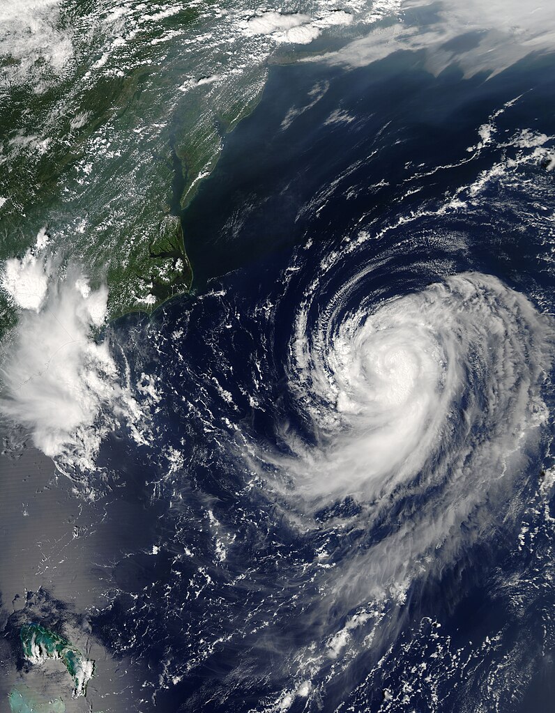
English: Irene was building towards a hurricane when the Moderate Resolution Imaging Spectroradiometer (MODIS) on NASA’s Aqua satellite captured this image at 2:20 p.m. U.S. Eastern Daylight Savings Time on August 14, 2005. By 11 p.m., Irene had become the third hurricane of the 2005 Atlantic hurricane season. The storm is moving northeast along the east coast of the United States and is not expected to make landfall, by National Hurricane Center predictions.
Along the top of the image, a pall of haze hugs the coast, blowing out over the Atlantic over the Chesapeake Bay. Such haze develops when hot, muggy weather caused by a high pressure system traps stagnant air. Emissions from cars and power plants build up, leading to hazy skies. The U.S. Environmental Protection Agency’s AirNow web site warned that air quality levels in the Mid-Atlantic states would be unhealthy for sensitive groups to unhealthy for all groups on August 13. Clearly, haze continued to affect the region on the following day. The large image provided above has a resolution of 500 meters per pixel. The MODIS Rapid Response Team provides the image in additional resolutions, including MODIS’ maximum resolution of 250 meters per pixel. |
| 日期 | |
| 來源 | http://earthobservatory.nasa.gov/NaturalHazards/quarterly.php?cat_id=10&y=2005&q=3 |
| 作者 | NASA; MODIS |
| 授權許可 (重用此檔案) |
Public domain |
授權條款
[編輯]
| 本作品由NASA創作,屬於公有領域。根據NASA的版權政策:“NASA的創作除非另有聲明否則不受版權保護。”(參見:Template:PD-USGov/zh,NASA版權政策或JPL圖像使用政策) | ||
 |
警告:
|
檔案歷史
點選日期/時間以檢視該時間的檔案版本。
| 日期/時間 | 縮圖 | 尺寸 | 使用者 | 備註 | |
|---|---|---|---|---|---|
| 目前 | 2023年7月31日 (一) 09:46 | | 5,600 × 7,200(6.23 MB) | Nino Marakot(留言 | 貢獻) | 250m resolution |
| 2009年12月29日 (二) 23:05 |  | 2,800 × 3,600(2.46 MB) | Cyclonebiskit(留言 | 貢獻) | {{Information |Description={{en|1=Irene was building towards a hurricane when the Moderate Resolution Imaging Spectroradiometer (MODIS) on NASA’s Aqua satellite captured this image at 2:20 p.m. U.S. Eastern Daylight Savings Time on August 14, 2005. By 1 |
無法覆蓋此檔案。
檔案用途
沒有使用此檔案的頁面。
全域檔案使用狀況
以下其他 wiki 使用了這個檔案:
- es.wikipedia.org 的使用狀況
- pt.wikipedia.org 的使用狀況
- tr.wikipedia.org 的使用狀況
- uk.wikipedia.org 的使用狀況
- www.wikidata.org 的使用狀況
- zh.wikipedia.org 的使用狀況