File:Irrawaddyrivermap.jpg
跳至導覽
跳至搜尋
預覽大小:421 × 599 像素。 其他解析度:168 × 240 像素 | 337 × 480 像素 | 862 × 1,227 像素。
原始檔案 (862 × 1,227 像素,檔案大小:208 KB,MIME 類型:image/jpeg)
說明
說明
添加單行說明來描述出檔案所代表的內容
摘要[編輯]
| 描述 |
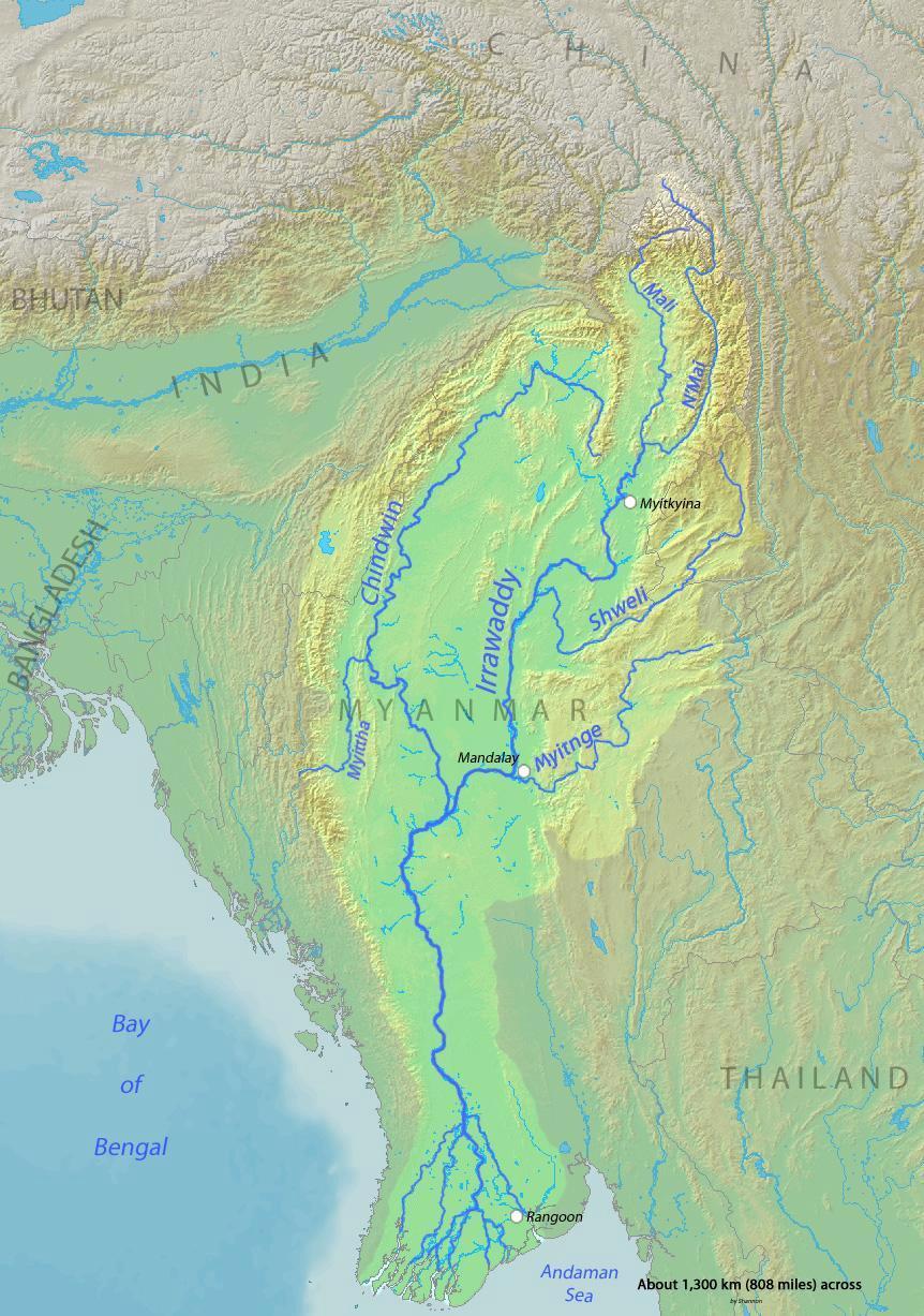
English: Map of the Irrawaddy River, which drains parts of Myanmar (Burma), Thailand and India into the Andaman Sea Français : Carte de l'Irrawaddy. Myitnge |
| 日期 | |
| 來源 | Background and river course data from http://www2.demis.nl/mapserver/mapper.asp |
| 作者 | Shannon |
授權條款[編輯]
我,本作品的著作權持有者,決定用以下授權條款發佈本作品:

|
已授權您依據自由軟體基金會發行的無固定段落、封面文字和封底文字GNU自由文件授權條款1.2版或任意後續版本,對本檔進行複製、傳播和/或修改。該協議的副本列在GNU自由文件授權條款中。 |
This file is licensed under the Creative Commons Attribution-Share Alike Attribution-Share Alike 4.0 International, 3.0 Unported, 2.5 Generic, 2.0 Generic and 1.0 Generic license.
- 您可以自由:
- 分享 – 複製、發佈和傳播本作品
- 重新修改 – 創作演繹作品
- 惟需遵照下列條件:
- 姓名標示 – 您必須指名出正確的製作者,和提供授權條款的連結,以及表示是否有對內容上做出變更。您可以用任何合理的方式來行動,但不得以任何方式表明授權條款是對您許可或是由您所使用。
- 相同方式分享 – 如果您利用本素材進行再混合、轉換或創作,您必須基於如同原先的相同或兼容的條款,來分布您的貢獻成品。
您可以選擇您需要的授權條款。
檔案歷史
點選日期/時間以檢視該時間的檔案版本。
| 日期/時間 | 縮圖 | 尺寸 | 使用者 | 備註 | |
|---|---|---|---|---|---|
| 目前 | 2015年12月1日 (二) 00:32 | | 862 × 1,227(208 KB) | Xufanc(留言 | 貢獻) | Myittha River |
| 2015年11月30日 (一) 08:30 |  | 862 × 1,227(208 KB) | Xufanc(留言 | 貢獻) | Reverted to version as of 08:22, 30 November 2015 (UTC) | |
| 2015年11月30日 (一) 08:28 |  | 862 × 1,227(208 KB) | Xufanc(留言 | 貢獻) | Reverted to version as of 08:18, 30 November 2015 (UTC) | |
| 2015年11月30日 (一) 08:25 |  | 862 × 1,227(208 KB) | Xufanc(留言 | 貢獻) | Reverted to version as of 08:18, 30 November 2015 (UTC) | |
| 2015年11月30日 (一) 08:22 |  | 862 × 1,227(208 KB) | Xufanc(留言 | 貢獻) | added name of tributary | |
| 2015年11月30日 (一) 08:18 |  | 862 × 1,227(208 KB) | Xufanc(留言 | 貢獻) | added name of tributary | |
| 2014年9月24日 (三) 06:38 |  | 862 × 1,227(219 KB) | Xufanc(留言 | 貢獻) | Corrected wrong label | |
| 2010年3月3日 (三) 04:06 |  | 862 × 1,227(653 KB) | Shannon1(留言 | 貢獻) | {{Information |Description={{en|1=Map of the Irrawaddy River, which drains parts of Myanmar (Burma), Thailand and India into the Andaman Sea}} |Source=Background and river course data from http://www2.demis.nl/mapserver/mapper.asp |Author=[[User:Shannonc |
無法覆蓋此檔案。
檔案用途
下列3個頁面有用到此檔案:
全域檔案使用狀況
以下其他 wiki 使用了這個檔案:
- af.wikipedia.org 的使用狀況
- ar.wikipedia.org 的使用狀況
- ast.wikipedia.org 的使用狀況
- azb.wikipedia.org 的使用狀況
- be-tarask.wikipedia.org 的使用狀況
- bg.wikipedia.org 的使用狀況
- bh.wikipedia.org 的使用狀況
- blk.wikipedia.org 的使用狀況
- bn.wikipedia.org 的使用狀況
- br.wikipedia.org 的使用狀況
- ca.wikipedia.org 的使用狀況
- cs.wikipedia.org 的使用狀況
- cy.wikipedia.org 的使用狀況
- de.wikipedia.org 的使用狀況
- en.wikipedia.org 的使用狀況
- en.wikinews.org 的使用狀況
- es.wikipedia.org 的使用狀況
- eu.wikipedia.org 的使用狀況
- fa.wikipedia.org 的使用狀況
- fr.wikipedia.org 的使用狀況
- gl.wikipedia.org 的使用狀況
- hi.wikipedia.org 的使用狀況
- hr.wikipedia.org 的使用狀況
- hu.wikipedia.org 的使用狀況
- hy.wikipedia.org 的使用狀況
- id.wikipedia.org 的使用狀況
- ja.wikipedia.org 的使用狀況
- ka.wikipedia.org 的使用狀況
- ko.wikipedia.org 的使用狀況
- mk.wikipedia.org 的使用狀況
- ml.wikipedia.org 的使用狀況
- my.wikipedia.org 的使用狀況
檢視此檔案的更多全域使用狀況。