File:Isla Hoste.png
Salta a la navegació
Salta a la cerca
No hi ha cap versió amb una resolució més gran.
Isla_Hoste.png (391 × 500 píxels, mida del fitxer: 410 Ko, tipus MIME: image/png)
Llegendes
Llegendes
Afegeix una explicació d'una línia del que representa aquest fitxer
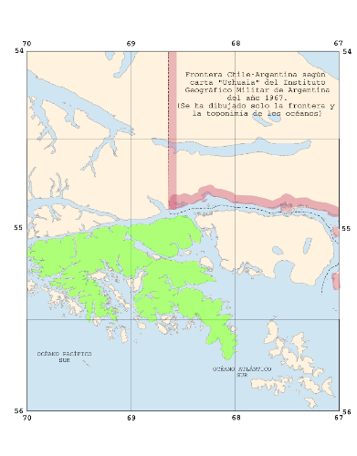
| Descripció | w:Hoste Island on a map of the southern part of the Archipelago of Tierra del Fuego, Borderline Chile-Argentina according to a map edited 1967 by the Argentine "Instituto Geografico Militar". The map is included in the book "El Conflicto del Beagle", edited by the Chilean Foreign Affairs Office, 1978, Switzerland. | ||||||||||
| Data | (UTC) | ||||||||||
| Font |
based on Image:Ushuaia.igm.arg.1967.png, changes made by myself self-made |
||||||||||
| Autor | this image: Man77, source made by User:Createaccount | ||||||||||
| Permís (Com reutilitzar aquest fitxer) |
|

Historial del fitxer
Cliqueu una data/hora per veure el fitxer tal com era aleshores.
| Data/hora | Miniatura | Dimensions | Usuari/a | Comentari | |
|---|---|---|---|---|---|
| actual | 14:20, 28 març 2008 | | 391 × 500 (410 Ko) | Man77 (discussió | contribucions) | {{Information |Description=w:Hoste Island on a map of the southern part of the Archipelago of Tierra del Fuego, Borderline Chile-Argentina according to a map edited 1967 by the Argentine "Instituto Geografico Militar". The map is included in the book |
No podeu sobreescriure aquest fitxer.
Ús del fitxer
No hi ha pàgines que utilitzin aquest fitxer.
Ús global del fitxer
Utilització d'aquest fitxer en altres wikis:
- Utilització a ca.wikipedia.org
- Utilització a fr.wikipedia.org
- Utilització a it.wikipedia.org
- Utilització a sh.wikipedia.org
- Utilització a www.wikidata.org
- Utilització a zh.wikipedia.org