File:Island of Ireland location map Down.svg
Salta a la navegació
Salta a la cerca

Mida d'aquesta previsualització PNG del fitxer SVG: 796 × 599 píxels. Altres resolucions: 319 × 240 píxels | 638 × 480 píxels | 1.020 × 768 píxels | 1.280 × 964 píxels | 2.560 × 1.928 píxels | 931 × 701 píxels.
Fitxer original (fitxer SVG, nominalment 931 × 701 píxels, mida del fitxer: 826 Ko)
Llegendes
Llegendes
Afegeix una explicació d'una línia del que representa aquest fitxer
| Descripció |
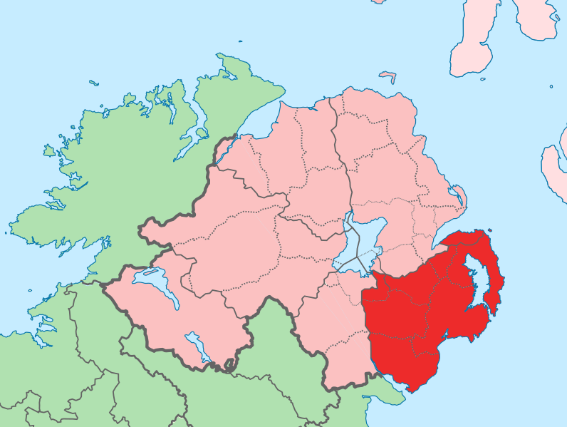
English: The island of Ireland, showing international border between Ireland and Northern Ireland, traditional provinces, traditional counties, and local authority areas in Ireland and Northern Ireland. |
| Data | (UTC) |
| Font | |
| Autor |
|
| Això és una imatge retocada, cosa que vol dir que ha estat alterada digitalment de la seva versió original. Modificacions: Added colours for specific county. L'original es pot veure a: Island of Ireland location map.svg:
|
Jo, el titular dels drets d'autor d'aquest treball, el public sota la següent llicència:
Aquest fitxer està subjecte a la llicència de Creative Commons Reconeixement i Compartir Igual 3.0 No adaptada.
- Sou lliure de:
- compartir – copiar, distribuir i comunicar públicament l'obra
- adaptar – fer-ne obres derivades
- Amb les condicions següents:
- reconeixement – Heu de donar la informació adequada sobre l'autor, proporcionar un enllaç a la llicència i indicar si s'han realitzat canvis. Podeu fer-ho amb qualsevol mitjà raonable, però de cap manera no suggereixi que l'autor us dóna suport o aprova l'ús que en feu.
- compartir igual – Si modifiqueu, transformeu, o generareu amb el material, haureu de distribuir les vostres contribucions sota una llicència similar o una de compatible com l'original
Registre original de càrregues[modifica]
This image is a derivative work of the following images:
- File:Island_of_Ireland_location_map.svg licensed with Cc-by-sa-3.0
- 2010-03-06T20:43:33Z Rannpháirtí anaithnid 1450x1807 (679207 Bytes) Fix incorrectly coloured isands.
- 2010-03-03T22:19:29Z Rannpháirtí anaithnid 1450x1807 (679744 Bytes) {{Information |Description={{de|Positionskarte von [[:de:Irland|Irland]]}} Quadratische Plattkarte, N-S-Streckung 170 %. Geographische Begrenzung der Karte: * N: 55.6° N * S: 51.2° N * W: 11.0° W * O: 5.0° W {{en|Location
Uploaded with derivativeFX
Historial del fitxer
Cliqueu una data/hora per veure el fitxer tal com era aleshores.
| Data/hora | Miniatura | Dimensions | Usuari/a | Comentari | |
|---|---|---|---|---|---|
| actual | 13:02, 19 jul 2010 | | 931 × 701 (826 Ko) | Mabuska (discussió | contribucions) | fixed scotland boundary |
| 11:45, 19 jul 2010 |  | 934 × 717 (828 Ko) | Mabuska (discussió | contribucions) | {{Information |Description={{en|The island of Ireland, showing international border between Northern Ireland and Republic of Ireland, traditional provinces, traditional counties, and local authority areas in the Republic of Ireland and Northern Ireland.}} |
No podeu sobreescriure aquest fitxer.
Ús del fitxer
Les 13 pàgines següents utilitzen aquest fitxer:
- Category:Archaeological sites in County Down
- Category:Births in County Down
- Category:Castles in County Down
- Category:County Down
- Category:County Down in the 1970s
- Category:County Down in the 19th century
- Category:County Down in the 21st century
- Category:Education in County Down
- Category:Maps of County Down
- Category:People of County Down
- Category:Rivers of County Down
- Category:Roads in County Down
- Category:Visitor attractions in County Down
Ús global del fitxer
Utilització d'aquest fitxer en altres wikis:
- Utilització a ar.wikipedia.org
- Utilització a ast.wikipedia.org
- Utilització a bg.wikipedia.org
- Utilització a ca.wikipedia.org
- Utilització a cs.wikipedia.org
- Utilització a de.wikipedia.org
- Utilització a en.wikipedia.org
- Utilització a eo.wikipedia.org
- Utilització a es.wikipedia.org
- Utilització a eu.wikipedia.org
- Belfast
- Newry
- Lisburn
- Bangor (Ipar Irlanda)
- Downpatrick
- Lankide:Euskaldunaa
- Newtownards
- Banbridge
- Down konderria
- Txantiloi:Down konderriko udalerriak
- Lurganville
- Ballynahinch (Down konderria)
- Carryduff
- Comber
- Donaghadee
- Dromore (Down konderria)
- Dundonald
- Holywood
- Kilkeel
- Newcastle (Down konderria)
- Warrenpoint
- Annahilt
- Annalong
- Annsborough
- Ardglass
- Atticall
- Aughnacloy (Down konderria)
- Ballela
- Balloo (Down konderria)
- Ballybannan
- Ballybeen
- Ballydargan
- Ballygowan
- Ballyhalbert
- Ballyhay
- Ballyhornan
- Ballykinler
- Ballylesson
- Ballylough
- Ballymacmaine
Vegeu més usos globals d'aquest fitxer.