File:Island of Ireland location map Kerry.svg
Pāriet uz navigāciju
Pāriet uz meklēšanu

Size of this PNG preview of this SVG file: 481 × 599 pikseļi. Citi izmēri: 192 × 240 pikseļi | 385 × 480 pikseļi | 616 × 768 pikseļi | 822 × 1 024 pikseļi | 1 643 × 2 048 pikseļi | 1 450 × 1 807 pikseļi.
Sākotnējais fails (SVG fails, definētais izmērs 1 450 × 1 807 pikseļi, faila izmērs: 642 KB)
Captions
Captions
Pievieno vienas rindiņas aprakstu, ko šis fails attēlo
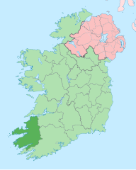
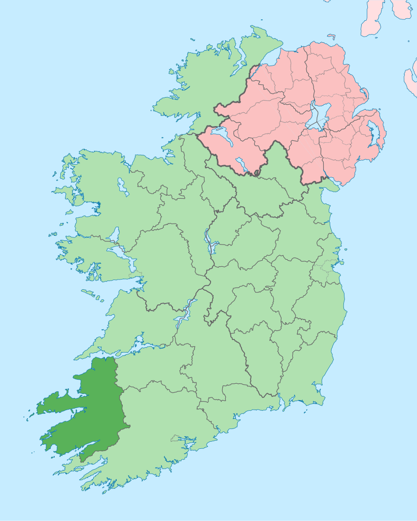
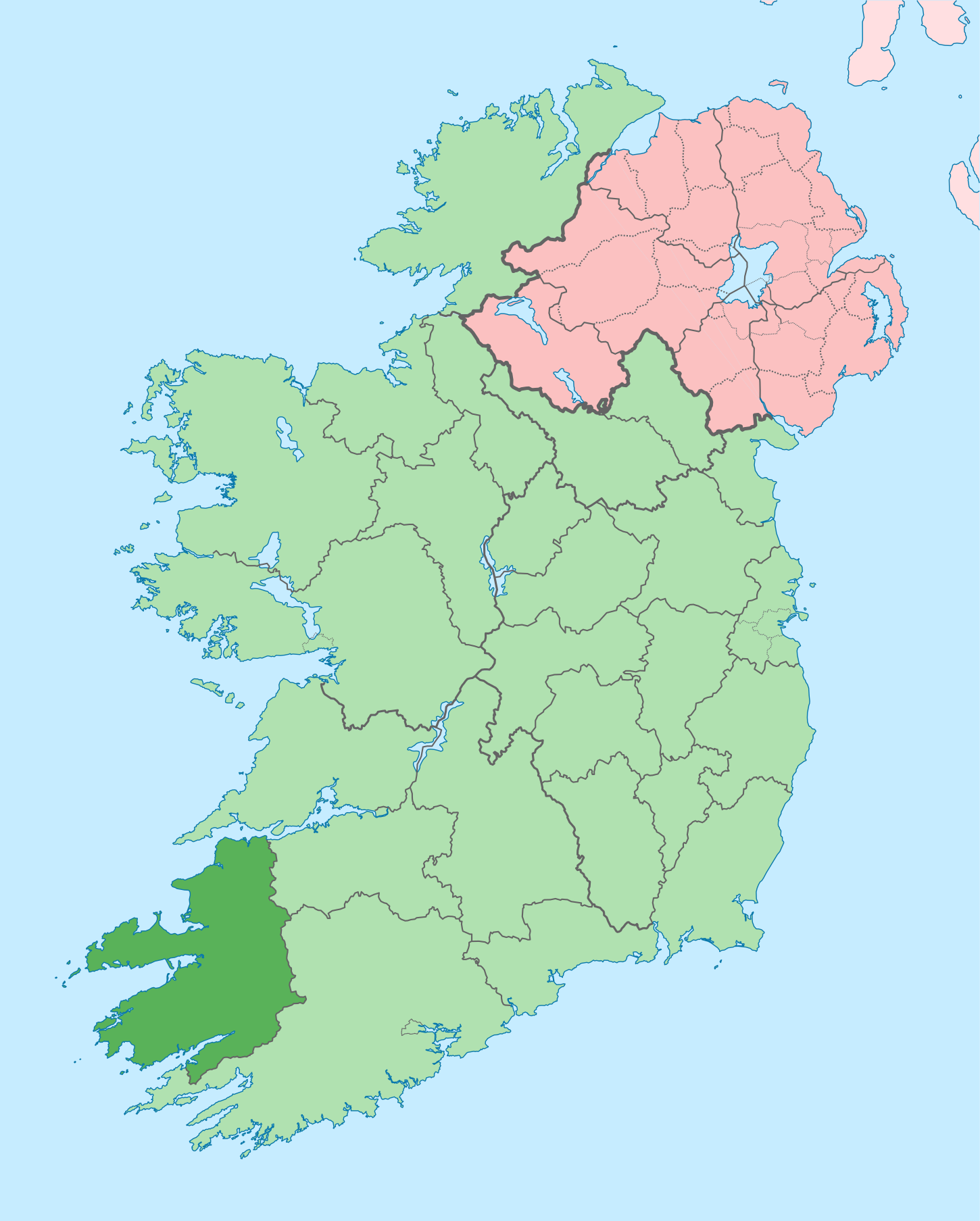
Kerry on a map
| Apraksts |
English: The island of Ireland, showing international border between Ireland and Northern Ireland, traditional provinces, traditional counties, and local authority areas in Ireland and Northern Ireland. |
| Datums | (UTC) |
| Avots | |
| Autors |
|
| This is a retouched picture, which means that it has been digitally altered from its original version. Modifications: Coloured in regions with county of article highlighted. The original can be viewed here: Island of Ireland location map.svg:
|
Es, šī darba autortiesību īpašnieks, publicēju to saskaņā ar šo licenci:
Šis fails tiek izplatīts saskaņā ar licences Creative Commons Atsauce-Līdzīgi Noteikumi 3.0 Vispārējiem noteikumiem.
- Jūs varat brīvi:
- koplietot – kopēt, izplatīt un pārraidīt darbu
- remiksēt – pielāgot darbu
- Saskaņā ar šādiem nosacījumiem:
- atsaucoties – Tev ir jānorāda autors, saite uz licenci un to, vai veiktas kādas izmaiņas. To var darīt jebkādā saprātīgā veidā, bet ne tādā, kas norādītu, ka licencētājs atbalsta tevi vai veidu, kā tu izmanto šo darbu.
- nemainot licenci – Ja tu miksē, pārveido vai izmanto materiālu, tev savs devums jāpublicē ar to pašu vai saderīgu licenci kā oriģināls.
Original upload log[labot šo sadaļu]
This image is a derivative work of the following images:
- File:Island_of_Ireland_location_map.svg licensed with Cc-by-sa-3.0
- 2010-03-06T20:43:33Z Rannpháirtí anaithnid 1450x1807 (679207 Bytes) Fix incorrectly coloured isands.
- 2010-03-03T22:19:29Z Rannpháirtí anaithnid 1450x1807 (679744 Bytes) {{Information |Description={{de|Positionskarte von [[:de:Irland|Irland]]}} Quadratische Plattkarte, N-S-Streckung 170 %. Geographische Begrenzung der Karte: * N: 55.6° N * S: 51.2° N * W: 11.0° W * O: 5.0° W {{en|Location
Uploaded with derivativeFX
Faila hronoloģija
Uzklikšķini uz datums/laiks kolonnā esošās saites, lai apskatītos, kā šis fails izskatījās tad.
| Datums/Laiks | Attēls | Izmēri | Dalībnieks | Komentārs | |
|---|---|---|---|---|---|
| tagadējais | 2020. gada 26. jūnijs, plkst. 15.58 | | 1 450 × 1 807 (642 KB) | Chipmunkdavis (diskusija | devums) | Per the Local Government Reform Act 2014, joining both Tipperarys and both Waterfords (and removing Limerick City code). Colouring in islands, cleaning up and grouping code to remove stray objects and show Galway and Lough Ree. |
| 2010. gada 19. jūlijs, plkst. 00.48 |  | 1 450 × 1 807 (821 KB) | Mabuska (diskusija | devums) | {{Information |Description={{en|The island of Ireland, showing international border between Northern Ireland and Republic of Ireland, traditional provinces, traditional counties, and local authority areas in the Republic of Ireland and Northern Ireland.}} |
Šo failu nevar pārrakstīt.
Faila lietojums
Šo failu izmanto šajās 12 lapās:
- Category:Archaeological sites in County Kerry
- Category:Beaches of County Kerry
- Category:Births in County Kerry
- Category:Castles in County Kerry
- Category:County Kerry
- Category:Maps of County Kerry
- Category:Murals in County Kerry
- Category:Museums in County Kerry
- Category:People of County Kerry
- Category:Protected areas of County Kerry
- Category:Rivers of County Kerry
- Category:Roads in County Kerry
Globālais faila lietojums
Šīs Vikipēdijas izmanto šo failu:
- Izmantojums ar.wikipedia.org
- Izmantojums ast.wikipedia.org
- Izmantojums bg.wikipedia.org
- Izmantojums br.wikipedia.org
- An Daingean
- Trá Lí
- Mainistir Ó dTorna
- Abhainn an Scáil
- Ard Fhearta
- Baile na nGall
- Baile an Sceilg
- Dairbhre
- An Baile Dubh
- Baile an Fheirtéaraigh
- Baile Uí Thaidhg
- Baile Mhic Eilegóid
- Cathair Uí Mhóráin
- Patrom:Kontelezh Ciarraí
- Brosnach
- Cathair Dhónaill
- Cathair Saidhbhín
- Béal Átha Longfoirt
- An Siopa Dubh
- Caisleán Ghriaire
- Izmantojums ca.wikipedia.org
- Comtat de Kerry
- Killarney
- Tralee
- Kenmare
- Plantilla:Comtat Kerry
- Listowel
- Baile an Fheirtéaraigh
- Baile an Sceilg
- Ceann Trá
- An Daingean
- Dún Chaoin
- Feothanach
- An Clochán
- Cé Bhréannain
- Lios Póil
- Cathair Dónall
- Baile na nGall
- Abhainn an Scáil
- Ballylongford
- Tarbert
- Ballybunion
- An Fosadh
- Baile an Mhuilinn (Kerry)
- An Com
- Izmantojums ceb.wikipedia.org
- Izmantojums cs.wikipedia.org
Skatīt šī faila pilno globālo izmantojumu.