File:Island of Ireland location map Kerry.svg
跳转到导航
跳转到搜索

此SVG文件的PNG预览的大小:481 × 599像素。 其他分辨率:192 × 240像素 | 385 × 480像素 | 616 × 768像素 | 822 × 1,024像素 | 1,643 × 2,048像素 | 1,450 × 1,807像素。
原始文件 (SVG文件,尺寸为1,450 × 1,807像素,文件大小:642 KB)
说明
说明
添加一行文字以描述该文件所表现的内容
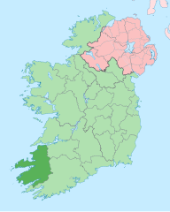
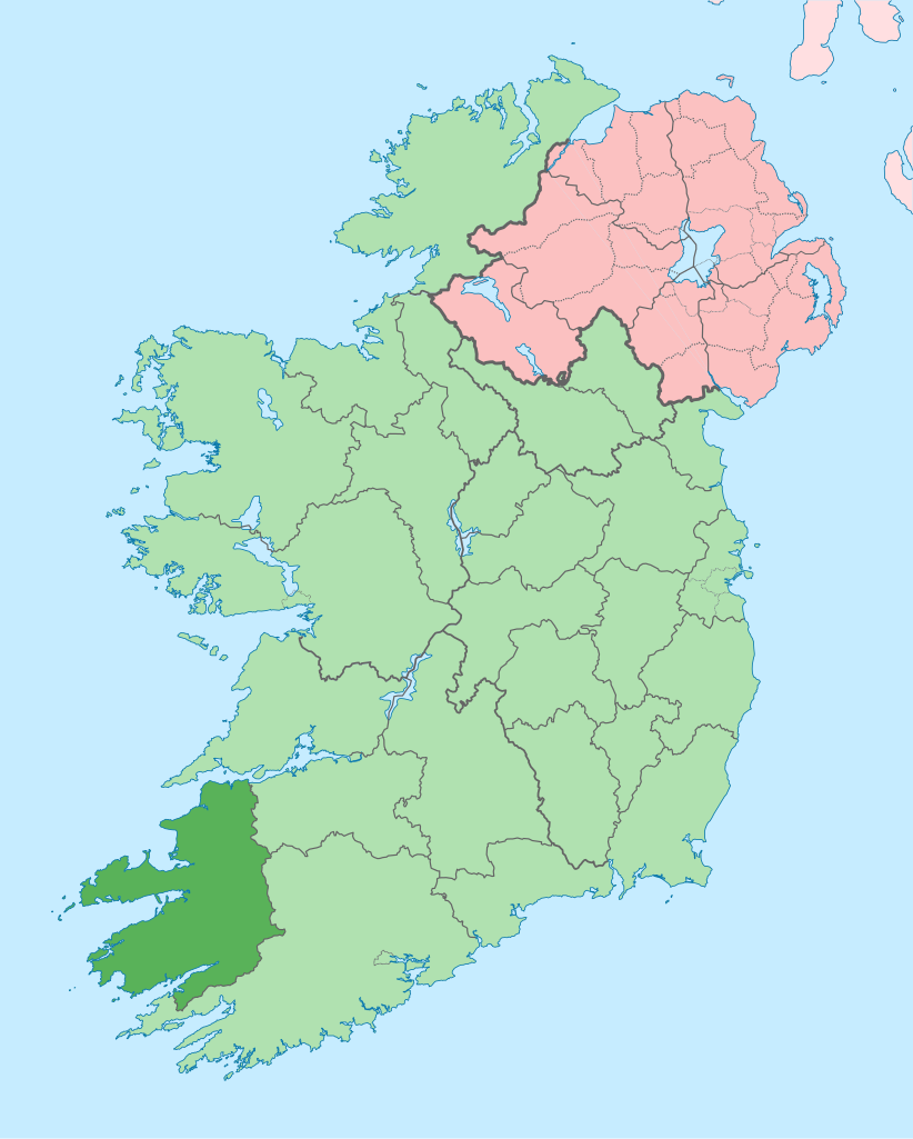
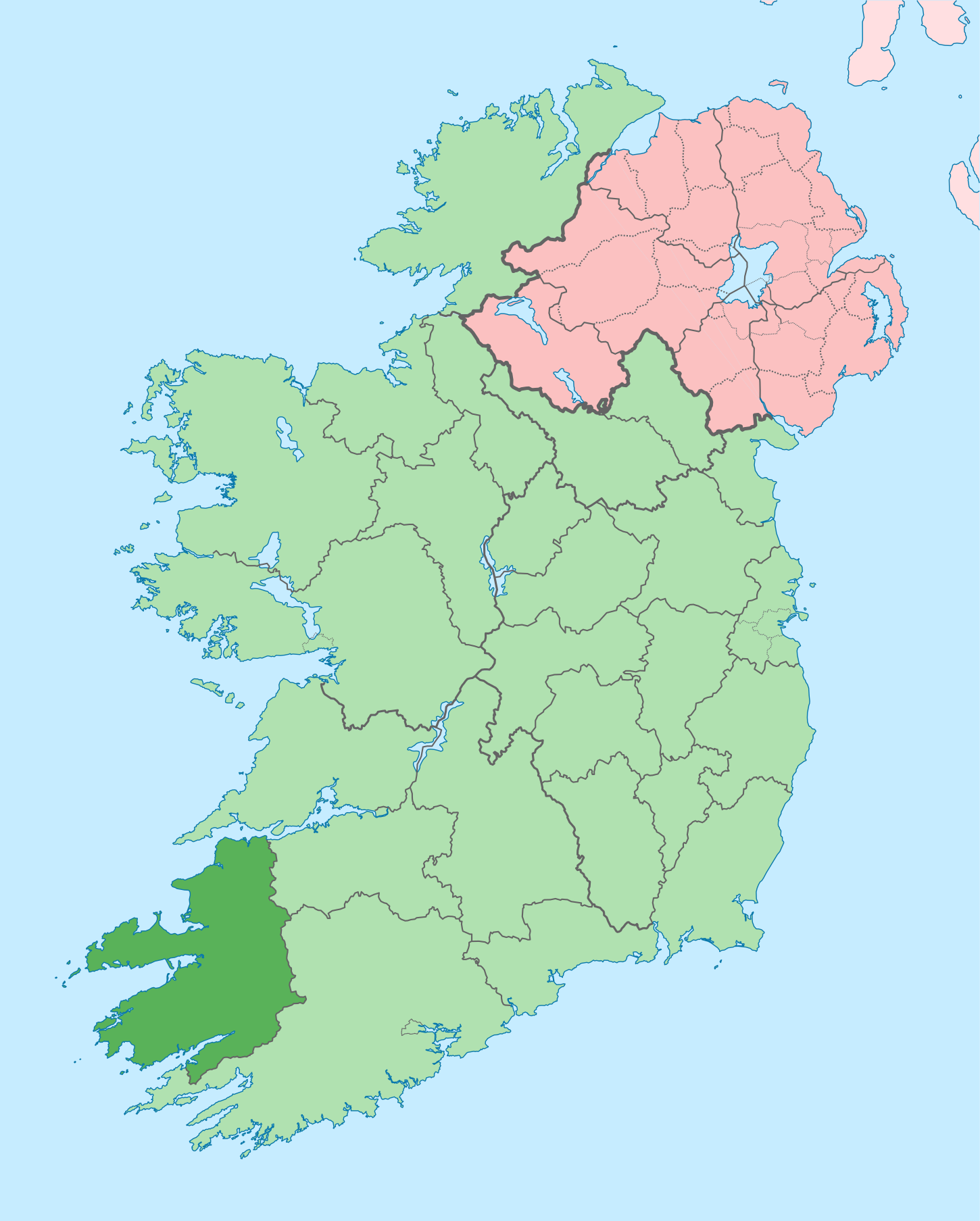
Kerry on a map
| 描述 |
English: The island of Ireland, showing international border between Ireland and Northern Ireland, traditional provinces, traditional counties, and local authority areas in Ireland and Northern Ireland. |
| 日期 | (UTC) |
| 来源 | |
| 作者 |
|
| 这是一张修改过的图片,这意味着它已在原版本的基础上通过软件进行了编辑,改动内容:Coloured in regions with county of article highlighted。其原始版本为:Island of Ireland location map.svg。修改者:Mabuska。
|
我,本作品著作权人,特此采用以下许可协议发表本作品:
本文件采用知识共享署名-相同方式共享 3.0 未本地化版本许可协议授权。
- 您可以自由地:
- 共享 – 复制、发行并传播本作品
- 修改 – 改编作品
- 惟须遵守下列条件:
- 署名 – 您必须对作品进行署名,提供授权条款的链接,并说明是否对原始内容进行了更改。您可以用任何合理的方式来署名,但不得以任何方式表明许可人认可您或您的使用。
- 相同方式共享 – 如果您再混合、转换或者基于本作品进行创作,您必须以与原先许可协议相同或相兼容的许可协议分发您贡献的作品。
原始上传日志
[编辑]
This image is a derivative work of the following images:
- File:Island_of_Ireland_location_map.svg licensed with Cc-by-sa-3.0
- 2010-03-06T20:43:33Z Rannpháirtí anaithnid 1450x1807 (679207 Bytes) Fix incorrectly coloured isands.
- 2010-03-03T22:19:29Z Rannpháirtí anaithnid 1450x1807 (679744 Bytes) {{Information |Description={{de|Positionskarte von [[:de:Irland|Irland]]}} Quadratische Plattkarte, N-S-Streckung 170 %. Geographische Begrenzung der Karte: * N: 55.6° N * S: 51.2° N * W: 11.0° W * O: 5.0° W {{en|Location
Uploaded with derivativeFX
文件历史
点击某个日期/时间查看对应时刻的文件。
| 日期/时间 | 缩略图 | 大小 | 用户 | 备注 | |
|---|---|---|---|---|---|
| 当前 | 2020年6月26日 (五) 15:58 | | 1,450 × 1,807(642 KB) | Chipmunkdavis(留言 | 贡献) | Per the Local Government Reform Act 2014, joining both Tipperarys and both Waterfords (and removing Limerick City code). Colouring in islands, cleaning up and grouping code to remove stray objects and show Galway and Lough Ree. |
| 2010年7月19日 (一) 00:48 |  | 1,450 × 1,807(821 KB) | Mabuska(留言 | 贡献) | {{Information |Description={{en|The island of Ireland, showing international border between Northern Ireland and Republic of Ireland, traditional provinces, traditional counties, and local authority areas in the Republic of Ireland and Northern Ireland.}} |
您不可以覆盖此文件。
文件用途
以下13个页面使用本文件:
- Commons:Files used on the AARoads Wiki/79
- Category:Archaeological sites in County Kerry
- Category:Beaches of County Kerry
- Category:Births in County Kerry
- Category:Castles in County Kerry
- Category:County Kerry
- Category:Maps of County Kerry
- Category:Murals in County Kerry
- Category:Museums in County Kerry
- Category:People of County Kerry
- Category:Protected areas of County Kerry
- Category:Rivers of County Kerry
- Category:Roads in County Kerry
全域文件用途
以下其他wiki使用此文件:
- ar.wikipedia.org上的用途
- ast.wikipedia.org上的用途
- bg.wikipedia.org上的用途
- br.wikipedia.org上的用途
- An Daingean
- Trá Lí
- Mainistir Ó dTorna
- Abhainn an Scáil
- Ard Fhearta
- Baile na nGall
- Baile an Sceilg
- Dairbhre
- An Baile Dubh
- Baile an Fheirtéaraigh
- Baile Uí Thaidhg
- Baile Mhic Eilegóid
- Cathair Uí Mhóráin
- Patrom:Kontelezh Ciarraí
- Brosnach
- Cathair Dhónaill
- Cathair Saidhbhín
- Béal Átha Longfoirt
- An Siopa Dubh
- Caisleán Ghriaire
- ca.wikipedia.org上的用途
- Comtat de Kerry
- Killarney
- Tralee
- Kenmare
- Plantilla:Comtat Kerry
- Listowel
- Baile an Fheirtéaraigh
- Baile an Sceilg
- Ceann Trá
- An Daingean
- Dún Chaoin
- Feothanach
- An Clochán
- Cé Bhréannain
- Lios Póil
- Cathair Dónall
- Baile na nGall
- Abhainn an Scáil
- Ballylongford
- Tarbert
- Ballybunion
- An Fosadh
- Baile an Mhuilinn (Kerry)
- An Com
- ceb.wikipedia.org上的用途
- cs.wikipedia.org上的用途
查看此文件的更多全域用途。