File:Island of Ireland location map Meath.svg
跳至導覽
跳至搜尋

此 SVG 檔案的 PNG 預覽的大小:481 × 599 像素。 其他解析度:192 × 240 像素 | 385 × 480 像素 | 616 × 768 像素 | 822 × 1,024 像素 | 1,643 × 2,048 像素 | 1,450 × 1,807 像素。
原始檔案 (SVG 檔案,表面大小:1,450 × 1,807 像素,檔案大小:642 KB)
說明
說明
添加單行說明來描述出檔案所代表的內容
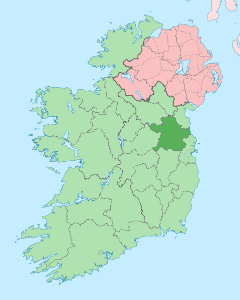
Meath on a map
| 描述 |
English: The island of Ireland, showing international border between Northern Ireland and Republic of Ireland, traditional provinces, traditional counties, and local authority areas in the Republic of Ireland and Northern Ireland. |
| 日期 | (UTC) |
| 來源 | |
| 作者 |
|
| 這是一張修飾過的圖片,即本圖片是用軟體修改過後的版本,修改的方式或內容有:Coloured in regions with county of article highlighted。原版圖片來源:Island of Ireland location map.svg。修改者:Mabuska。
|
我,本作品的著作權持有者,決定用以下授權條款發佈本作品:
此檔案採用創用CC 姓名標示-相同方式分享 3.0 未在地化版本授權條款。
- 您可以自由:
- 分享 – 複製、發佈和傳播本作品
- 重新修改 – 創作演繹作品
- 惟需遵照下列條件:
- 姓名標示 – 您必須指名出正確的製作者,和提供授權條款的連結,以及表示是否有對內容上做出變更。您可以用任何合理的方式來行動,但不得以任何方式表明授權條款是對您許可或是由您所使用。
- 相同方式分享 – 如果您利用本素材進行再混合、轉換或創作,您必須基於如同原先的相同或兼容的條款,來分布您的貢獻成品。
原始上傳日誌
[編輯]
This image is a derivative work of the following images:
- File:Island_of_Ireland_location_map.svg licensed with Cc-by-sa-3.0
- 2010-03-06T20:43:33Z Rannpháirtí anaithnid 1450x1807 (679207 Bytes) Fix incorrectly coloured isands.
- 2010-03-03T22:19:29Z Rannpháirtí anaithnid 1450x1807 (679744 Bytes) {{Information |Description={{de|Positionskarte von [[:de:Irland|Irland]]}} Quadratische Plattkarte, N-S-Streckung 170 %. Geographische Begrenzung der Karte: * N: 55.6° N * S: 51.2° N * W: 11.0° W * O: 5.0° W {{en|Location
Uploaded with derivativeFX
檔案歷史
點選日期/時間以檢視該時間的檔案版本。
| 日期/時間 | 縮圖 | 尺寸 | 使用者 | 備註 | |
|---|---|---|---|---|---|
| 目前 | 2020年7月3日 (五) 09:16 | | 1,450 × 1,807(642 KB) | Chipmunkdavis(留言 | 貢獻) | Per the Local Government Reform Act 2014, joining both Tipperarys and both Waterfords (and removing Limerick City code). Colouring in islands, cleaning up and grouping code to remove stray objects and show Galway and Lough Ree. |
| 2010年7月19日 (一) 01:00 |  | 1,450 × 1,807(815 KB) | Mabuska(留言 | 貢獻) | {{Information |Description={{en|The island of Ireland, showing international border between Northern Ireland and Republic of Ireland, traditional provinces, traditional counties, and local authority areas in the Republic of Ireland and Northern Ireland.}} |
無法覆蓋此檔案。
檔案用途
下列9個頁面有用到此檔案:
- Commons:Files used on the AARoads Wiki/79
- Category:Archaeological sites in County Meath
- Category:Births in County Meath
- Category:Castles in County Meath
- Category:County Meath
- Category:People of County Meath
- Category:Rivers of County Meath
- Category:Roads in County Meath
- Category:Views of County Meath
全域檔案使用狀況
以下其他 wiki 使用了這個檔案:
- ar.wikipedia.org 的使用狀況
- ast.wikipedia.org 的使用狀況
- bg.wikipedia.org 的使用狀況
- ca.wikipedia.org 的使用狀況
- ceb.wikipedia.org 的使用狀況
- cs.wikipedia.org 的使用狀況
- da.wikipedia.org 的使用狀況
- de.wikivoyage.org 的使用狀況
- en.wikipedia.org 的使用狀況
- Slane
- County Meath
- Trim, County Meath
- List of Ireland-related topics
- Navan
- Kells, County Meath
- Julianstown
- Oldcastle, County Meath
- Carnaross
- Kiltale
- Dunshaughlin
- Duleek
- Faughan Hill
- Moynalty
- Ratoath
- Ráth Chairn
- Skryne
- Nobber
- Dunboyne
- 2005 Meath by-election
- Loch Gabhar
- Ardcath
- Monknewtown
- Butlin's Mosney
- Laytown
- Curraha
檢視此檔案的更多全域使用狀況。