File:Island of Ireland location map Tyrone.svg
跳至導覽
跳至搜尋

此 SVG 檔案的 PNG 預覽的大小:796 × 599 像素。 其他解析度:319 × 240 像素 | 638 × 480 像素 | 1,020 × 768 像素 | 1,280 × 964 像素 | 2,560 × 1,928 像素 | 931 × 701 像素。
原始檔案 (SVG 檔案,表面大小:931 × 701 像素,檔案大小:826 KB)
說明
說明
添加單行說明來描述出檔案所代表的內容
| 描述 |
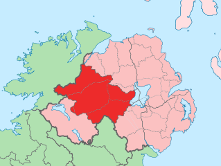
English: The island of Ireland, showing international border between Northern Ireland and Republic of Ireland, traditional provinces, traditional counties, and local authority areas in the Republic of Ireland and Northern Ireland. |
||
| 日期 | (UTC) | ||
| 來源 | Island of Ireland location map.svg | ||
| 作者 | |||
| SVG開發 | 本向量圖形使用Adobe Illustrator創作。
|
我,本作品的著作權持有者,決定用以下授權條款發佈本作品:
此檔案採用創用CC 姓名標示-相同方式分享 3.0 未在地化版本授權條款。
- 您可以自由:
- 分享 – 複製、發佈和傳播本作品
- 重新修改 – 創作演繹作品
- 惟需遵照下列條件:
- 姓名標示 – 您必須指名出正確的製作者,和提供授權條款的連結,以及表示是否有對內容上做出變更。您可以用任何合理的方式來行動,但不得以任何方式表明授權條款是對您許可或是由您所使用。
- 相同方式分享 – 如果您利用本素材進行再混合、轉換或創作,您必須基於如同原先的相同或兼容的條款,來分布您的貢獻成品。
原始上傳日誌
[編輯]
This image is a derivative work of the following images:
- Island of Ireland location map.svg licensed with Cc-by-sa-3.0
- 2010-03-06T20:43:33Z Rannpháirtí anaithnid 1450x1807 (679207 Bytes) Fix incorrectly coloured isands.
- 2010-03-03T22:19:29Z Rannpháirtí anaithnid 1450x1807 (679744 Bytes) {{Information |Description={{de|Positionskarte von [[:de:Irland|Irland]]}} Quadratische Plattkarte, N-S-Streckung 170 %. Geographische Begrenzung der Karte: * N: 55.6° N * S: 51.2° N * W: 11.0° W * O: 5.0° W {{en|Location
Uploaded with derivativeFX
檔案歷史
點選日期/時間以檢視該時間的檔案版本。
| 日期/時間 | 縮圖 | 尺寸 | 使用者 | 備註 | |
|---|---|---|---|---|---|
| 目前 | 2010年7月19日 (一) 12:53 | | 931 × 701(826 KB) | Mabuska(留言 | 貢獻) | another attempt |
| 2010年7月19日 (一) 12:41 |  | 931 × 701(819 KB) | Mabuska(留言 | 貢獻) | fixed boundaries | |
| 2010年7月19日 (一) 11:20 |  | 934 × 712(827 KB) | Mabuska(留言 | 貢獻) | {{Information |Description={{en|The island of Ireland, showing international border between Northern Ireland and Republic of Ireland, traditional provinces, traditional counties, and local authority areas in the Republic of Ireland and Northern Ireland.}} |
無法覆蓋此檔案。
檔案用途
下列15個頁面有用到此檔案:
- File:Island of Ireland location map Tyrone with Lake Torrent.png
- Category:Archaeological sites in County Tyrone
- Category:Births in County Tyrone
- Category:Castles in County Tyrone
- Category:County Tyrone
- Category:County Tyrone in the 1980s
- Category:County Tyrone in the 1990s
- Category:County Tyrone in the 19th century
- Category:County Tyrone in the 21st century
- Category:Education in County Tyrone
- Category:Maps of County Tyrone
- Category:Populated places in County Tyrone
- Category:Rivers of County Tyrone
- Category:Roads in County Tyrone
- Category:Visitor attractions in County Tyrone
全域檔案使用狀況
以下其他 wiki 使用了這個檔案:
- an.wikipedia.org 的使用狀況
- ar.wikipedia.org 的使用狀況
- ast.wikipedia.org 的使用狀況
- bg.wikipedia.org 的使用狀況
- ca.wikipedia.org 的使用狀況
- cs.wikipedia.org 的使用狀況
- de.wikipedia.org 的使用狀況
- en.wikipedia.org 的使用狀況
- es.wikipedia.org 的使用狀況
- eu.wikipedia.org 的使用狀況
- Omagh
- Lankide:Euskaldunaa
- Dungannon
- Cookstown
- Strabane
- Tyrone konderria
- Txantiloi:Tyrone konderriko udalerriak
- Coagh
- Coalisland
- Altamuskin
- Altishane
- Altmore
- Ardboe
- Ardstraw
- Artigarvan
- Augher
- Aughnacloy (Tyrone konderria)
- Ballygawley (Tyrone konderria)
- Ballymagorry
- Ballymully Glebe
- Benburb
- Beragh
- Brackaville
- Bready
- Brockagh
- Caledon (Tyrone konderria)
- Cappagh (Tyrone konderria)
- Carnteel
- Carrickmore
- Castlecaulfield
- Castlederg
- Clady (Tyrone konderria)
- Clanabogan
- Clogher
- Cranagh
- Creggan (Tyrone konderria)
- Derrycrin
- Derryloughan (Tyrone konderria)
檢視此檔案的更多全域使用狀況。