File:Isle of Man location map.svg
Spring til navigation
Spring til søgning

Size of this PNG preview of this SVG file: 654 × 600 pixels. Andre opløsninger: 262 × 240 pixels | 524 × 480 pixels | 838 × 768 pixels | 1.117 × 1.024 pixels | 2.234 × 2.048 pixels | 1.200 × 1.100 pixels.
Oprindelig fil (SVG fil, basisstørrelse 1.200 × 1.100 pixels, filstørrelse: 93 KB)
Captions
Captions
Tilføj en kort forklaring på en enkelt linje om hvad filen viser
| Beskrivelse |
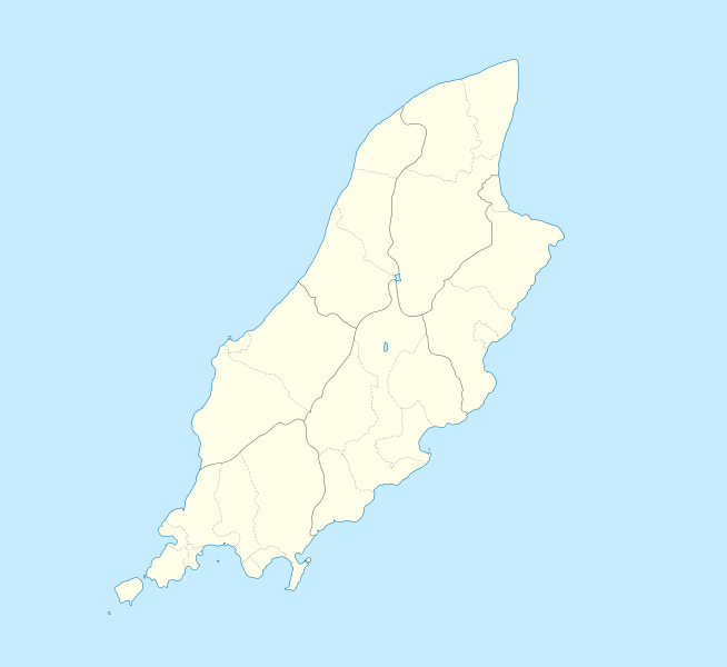
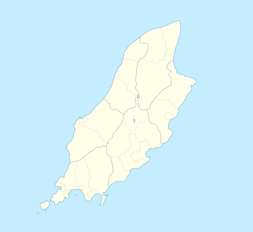
English: Location map of the Isle of Man, showing sheadings as well as local authorities (towns, villages, districts, parishes).
Geographic limits of the map:
|
| Dato | |
| Kilde | |
| Forfatter |
|
Jeg, dette værks ophavsretsindehaver, udgiver hermed værket under den følgende licens:
Denne fil er udgivet under Creative Commons Navngivelse – Del på samme vilkår 2.5 Generisk, 2.0 Generisk og 1.0 Generisk-licensen.
- Du må frit:
- at dele – at kopiere, distribuere og overføre værket
- at remixe – at tilpasse værket
- Under følgende vilkår:
- kreditering – Du skal give passende kreditering, angive et link til licensen, og oplyse om der er foretaget ændringer. Du må gøre det på enhver fornuftig måde, men ikke på en måde der antyder at licensgiveren godkender dig eller din anvendelse.
- deling på samme vilkår – Hvis du bearbejder, ændrer eller bygger videre på dette værk, skal du distribuere dine bidrag under den samme eller en kompatibel licens som originalen.
| Denne fil er udgivet under Creative Commons Kreditering-Del på samme vilkår 3.0 Ikke-porteret-licensen. | ||
| ||
| Denne licens blev tilføjet som en del af GFDL-licensopdateringen. |

|
Tilladelse er givet til at kopiere, distribuere og/eller ændre dette dokument under betingelserne i GNU Free Documentation License', Version 1.2 eller enhver senere version udgivet af Free Software Foundation; uden et invariant afsnit, ingen forsidetekster, og ingen bagsidetekst. En kopi af licensen er inkluderet i afsnittet GNU Free Documentation License. |
Du kan vælge den licens du foretrækker.
Oprindelig oplægningslog
[redigér]
This image is a derivative work of the following images:
- File:IsleOfMan_SheadingsAndParishes-en.svg licensed with Cc-by-sa-2.5,2.0,1.0, Cc-by-sa-3.0-migrated, GFDL
- 2008-01-17T12:48:28Z Sémhur 1200x1100 (227618 Bytes) Update
- 2007-05-29T20:36:04Z Sémhur 1200x1100 (364350 Bytes) {{Information |Description=Map in english of the [[:en:Isle of Man|Isle of Man]], with bounds of sheadings, towns, villages, districts and parishes. |Source=Own work. Based on maps [[:Image:Isle of Man map-fr.svg]], [[:Image:
Uploaded with derivativeFX
Filhistorik
Klik på en dato/tid for at se filen som den så ud på det tidspunkt.
| Dato/tid | Miniaturebillede | Dimensioner | Bruger | Kommentar | |
|---|---|---|---|---|---|
| nuværende | 24. sep. 2009, 23:00 | | 1.200 × 1.100 (93 KB) | Entlinkt (diskussion | bidrag) | {{Information |Description={{en|1=Location map of the Isle of Man, showing sheadings as well as local authorities (towns, villages, districts, parishes). Geographic limits of the map: * W: -4° 58' 0" * E: -4° 7' 0" * S: 54° 0' 0" * N: 54° 27' 30"}} |
Du kan ikke overskrive denne fil.
Filanvendelse
De følgende 31 sider bruger denne fil:
- File:Andreas in Isle of Man.svg
- File:Arbory in Isle of Man.svg
- File:Ayre in Isle of Man.svg
- File:Ballaugh in Isle of Man.svg
- File:Braddan in Isle of Man.svg
- File:Bride in Isle of Man.svg
- File:Castletown in Isle of Man.svg
- File:Douglas in Isle of Man.svg
- File:Garff in Isle of Man.svg
- File:German in Isle of Man.svg
- File:Glenfabe in Isle of Man.svg
- File:Isle of Man location map with km-mi distance scale 654px-size-png.png
- File:Jurby in Isle of Man.svg
- File:Laxey in Isle of Man.svg
- File:Lezayre in Isle of Man.svg
- File:Lonan in Isle of Man.svg
- File:Malew in Isle of Man.svg
- File:Marown in Isle of Man.svg
- File:Maughold in Isle of Man.svg
- File:Michael in Isle of Man.svg
- File:Michael in Isle of Man (sheading).svg
- File:Middle in Isle of Man.svg
- File:Onchan in Isle of Man.svg
- File:Patrick in Isle of Man.svg
- File:Peel in Isle of Man.svg
- File:Port Erin in Isle of Man.svg
- File:Port St Mary in Isle of Man.svg
- File:Ramsey in Isle of Man.svg
- File:Rushen in Isle of Man.svg
- File:Rushen in Isle of Man (sheading).svg
- File:Santon in Isle of Man.svg
.svg)
.svg)
Global filanvendelse
Følgende andre wikier anvender denne fil:
- Anvendelser på af.wikipedia.org
- Anvendelser på ar.wikipedia.org
- Anvendelser på ast.wikipedia.org
- Anvendelser på azb.wikipedia.org
- Anvendelser på ba.wikipedia.org
- Anvendelser på be.wikipedia.org
- Anvendelser på bg.wikipedia.org
- Anvendelser på bn.wikipedia.org
- Anvendelser på br.wikipedia.org
- Anvendelser på ceb.wikipedia.org
- Plantilya:Location map Isle of Man
- German
- Patrick
- Bride
- Andreas
- Douglas
- Saint Michaels Island
- Port Douglas
- Peel
- Isle of Man (pagklaro)
- Douglas Bay
- Isle of Man
- Santon
- Clay Head
- Craig Rock
- Ramsey Bay
- Rue Point
- Ramsey
- River Glass
- Chicken Rock
- Castletown
- Calf Sound
- Point of Ayre
- Crosby
- Little Ness
- Laksaa
- Snaefell
Vis flere globale anvendelser af denne fil.