File:Isle of Man location map.svg
ナビゲーションに移動
検索に移動

この SVG ファイルのこの PNG プレビューのサイズ: 654 × 600 ピクセル. その他の解像度: 262 × 240 ピクセル | 524 × 480 ピクセル | 838 × 768 ピクセル | 1,117 × 1,024 ピクセル | 2,234 × 2,048 ピクセル | 1,200 × 1,100 ピクセル。
元のファイル (SVG ファイル、1,200 × 1,100 ピクセル、ファイルサイズ: 93キロバイト)
キャプション
キャプション
このファイルの内容を1行で記述してください
| 解説 |
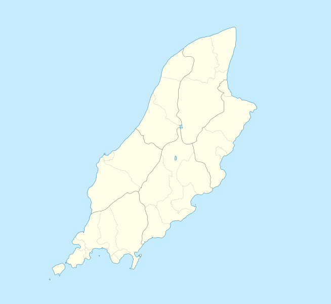
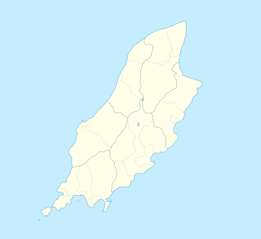
English: Location map of the Isle of Man, showing sheadings as well as local authorities (towns, villages, districts, parishes).
Geographic limits of the map:
|
| 日付 | |
| 原典 | |
| 作者 |
|
この作品の著作権者である私は、この作品を以下のライセンスで提供します。
- あなたは以下の条件に従う場合に限り、自由に
- 共有 – 本作品を複製、頒布、展示、実演できます。
- 再構成 – 二次的著作物を作成できます。
- あなたの従うべき条件は以下の通りです。
- 表示 – あなたは適切なクレジットを表示し、ライセンスへのリンクを提供し、変更があったらその旨を示さなければなりません。これらは合理的であればどのような方法で行っても構いませんが、許諾者があなたやあなたの利用行為を支持していると示唆するような方法は除きます。
- 継承 – もしあなたがこの作品をリミックスしたり、改変したり、加工した場合には、あなたはあなたの貢献部分を元の作品とこれと同一または互換性があるライセンスの下に頒布しなければなりません。
| このファイルはクリエイティブ・コモンズ 表示-継承 3.0 非移植ライセンスのもとに利用を許諾されています。 | ||
| ||
| このライセンスのテンプレートは、GFDLのライセンス・アップデートによりこのファイルに追加されたものです。 |

|
この文書は、フリーソフトウェア財団発行のGNUフリー文書利用許諾書 (GNU Free Documentation License) 1.2またはそれ以降のバージョンの規約に基づき、複製や再配布、改変が許可されます。不可変更部分、表紙、背表紙はありません。このライセンスの複製は、GNUフリー文書利用許諾書という章に含まれています。 |
あなたは上記のライセンスから、どれか一つ以上を選択できます。
元のアップロードログ[編集]
This image is a derivative work of the following images:
- File:IsleOfMan_SheadingsAndParishes-en.svg licensed with Cc-by-sa-2.5,2.0,1.0, Cc-by-sa-3.0-migrated, GFDL
- 2008-01-17T12:48:28Z Sémhur 1200x1100 (227618 Bytes) Update
- 2007-05-29T20:36:04Z Sémhur 1200x1100 (364350 Bytes) {{Information |Description=Map in english of the [[:en:Isle of Man|Isle of Man]], with bounds of sheadings, towns, villages, districts and parishes. |Source=Own work. Based on maps [[:Image:Isle of Man map-fr.svg]], [[:Image:
Uploaded with derivativeFX
ファイルの履歴
過去の版のファイルを表示するには、その版の日時をクリックしてください。
| 日付と時刻 | サムネイル | 寸法 | 利用者 | コメント | |
|---|---|---|---|---|---|
| 現在の版 | 2009年9月24日 (木) 23:00 | | 1,200 × 1,100 (93キロバイト) | Entlinkt (トーク | 投稿記録) | {{Information |Description={{en|1=Location map of the Isle of Man, showing sheadings as well as local authorities (towns, villages, districts, parishes). Geographic limits of the map: * W: -4° 58' 0" * E: -4° 7' 0" * S: 54° 0' 0" * N: 54° 27' 30"}} |
このファイルは上書きできません。
ファイルの使用状況
以下の 31 ページがこのファイルを使用しています:
- File:Andreas in Isle of Man.svg
- File:Arbory in Isle of Man.svg
- File:Ayre in Isle of Man.svg
- File:Ballaugh in Isle of Man.svg
- File:Braddan in Isle of Man.svg
- File:Bride in Isle of Man.svg
- File:Castletown in Isle of Man.svg
- File:Douglas in Isle of Man.svg
- File:Garff in Isle of Man.svg
- File:German in Isle of Man.svg
- File:Glenfabe in Isle of Man.svg
- File:Isle of Man location map with km-mi distance scale 654px-size-png.png
- File:Jurby in Isle of Man.svg
- File:Laxey in Isle of Man.svg
- File:Lezayre in Isle of Man.svg
- File:Lonan in Isle of Man.svg
- File:Malew in Isle of Man.svg
- File:Marown in Isle of Man.svg
- File:Maughold in Isle of Man.svg
- File:Michael in Isle of Man.svg
- File:Michael in Isle of Man (sheading).svg
- File:Middle in Isle of Man.svg
- File:Onchan in Isle of Man.svg
- File:Patrick in Isle of Man.svg
- File:Peel in Isle of Man.svg
- File:Port Erin in Isle of Man.svg
- File:Port St Mary in Isle of Man.svg
- File:Ramsey in Isle of Man.svg
- File:Rushen in Isle of Man.svg
- File:Rushen in Isle of Man (sheading).svg
- File:Santon in Isle of Man.svg
.svg)
.svg)
グローバルなファイル使用状況
以下に挙げる他のウィキがこの画像を使っています:
- af.wikipedia.org での使用状況
- ar.wikipedia.org での使用状況
- ast.wikipedia.org での使用状況
- azb.wikipedia.org での使用状況
- ba.wikipedia.org での使用状況
- be.wikipedia.org での使用状況
- bg.wikipedia.org での使用状況
- bn.wikipedia.org での使用状況
- br.wikipedia.org での使用状況
- ceb.wikipedia.org での使用状況
- Plantilya:Location map Isle of Man
- German
- Patrick
- Bride
- Andreas
- Douglas
- Saint Michaels Island
- Port Douglas
- Peel
- Isle of Man (pagklaro)
- Douglas Bay
- Isle of Man
- Santon
- Clay Head
- Craig Rock
- Ramsey Bay
- Rue Point
- Ramsey
- River Glass
- Chicken Rock
- Castletown
- Calf Sound
- Point of Ayre
- Crosby
- Little Ness
- Laksaa
- Snaefell
このファイルのグローバル使用状況を表示する。