File:Japan Relief Map of Land and Seabed.png
出自Wikimedia Commons
跳至導覽
跳至搜尋

預覽大小:727 × 599 像素。 其他解析度:291 × 240 像素 | 582 × 480 像素 | 932 × 768 像素 | 1,242 × 1,024 像素 | 2,117 × 1,745 像素。
原始檔案 (2,117 × 1,745 像素,檔案大小:7.47 MB,MIME 類型:image/png)
檔案資訊
結構化資料
說明
說明
添加單行說明來描述出檔案所代表的內容
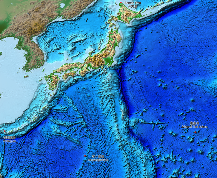
Relief map of the land and seabed of Japan
摘要
[編輯]| 描述Japan Relief Map of Land and Seabed.png |
English: This is a relief map of the land and the seabed of Japan. It shows the surface and underwater terrain of the Japanese archipelago. It includes all the Japanese islands such as Minami-Tori-Shima, Benten-jima, Okinotorishima and Yonaguni.
日本語: 日本近海海底地形図と日本列島。 |
| 日期 | |
| 來源 | ETOPO1, Global Relief Model, https://www.ngdc.noaa.gov/mgg/global/global.html |
| 作者 | NASA, National Geophysical Data Center, NOAA |
授權條款
[編輯]| Public domainPublic domainfalsefalse |
| 本作品由NASA創作,屬於公有領域。根據NASA的版權政策:“NASA的創作除非另有聲明否則不受版權保護。”(參見:Template:PD-USGov/zh,NASA版權政策或JPL圖像使用政策) |  | |
 |
警告:
|
檔案歷史
點選日期/時間以檢視該時間的檔案版本。
| 日期/時間 | 縮圖 | 尺寸 | 用戶 | 備註 | |
|---|---|---|---|---|---|
| 目前 | 2019年8月5日 (一) 15:07 |  | 2,117 × 1,745(7.47 MB) | Artanisen(對話 | 貢獻) | The continent geography is darker to highlight the Japanese archipelago. |
| 2019年7月22日 (一) 06:29 |  | 2,117 × 1,745(7.54 MB) | Artanisen(對話 | 貢獻) | User created page with UploadWizard |
無法覆蓋此檔案。
檔案用途
全域檔案使用狀況
以下其他 wiki 使用了這個檔案:
- ar.wikipedia.org 的使用狀況
- ast.wikipedia.org 的使用狀況
- be.wikipedia.org 的使用狀況
- ca.wikipedia.org 的使用狀況
- de.wikipedia.org 的使用狀況
- en.wikipedia.org 的使用狀況
- es.wikipedia.org 的使用狀況
- fr.wikipedia.org 的使用狀況
- id.wikipedia.org 的使用狀況
- it.wikipedia.org 的使用狀況
- ja.wikipedia.org 的使用狀況
- min.wikipedia.org 的使用狀況
- pnb.wikipedia.org 的使用狀況
- pt.wikipedia.org 的使用狀況
- ru.wikipedia.org 的使用狀況
- sl.wikipedia.org 的使用狀況
- sr.wikipedia.org 的使用狀況
- tl.wikipedia.org 的使用狀況
- uk.wikipedia.org 的使用狀況
- vi.wikipedia.org 的使用狀況
- www.wikidata.org 的使用狀況
- zh-min-nan.wikipedia.org 的使用狀況
- zh.wikipedia.org 的使用狀況
詮釋資料
此檔案中包含其他資訊,這些資訊可能是由數位相機或掃描器在建立或數位化過程中所新增的。若檔案自原始狀態已被修改,一些詳細資料可能無法完整反映出已修改的檔案。
| 使用軟體 |
|---|