File:Jeanne-22-1945z-T50-discussion2100z.png
跳至導覽
跳至搜尋
無更高解析度可提供。
Jeanne-22-1945z-T50-discussion2100z.png (188 × 154 像素,檔案大小:63 KB,MIME 類型:image/png)
說明
說明
添加單行說明來描述出檔案所代表的內容
授權條款[編輯]
本圖像屬於公有領域,因該作品最初來自於美國國家海洋和大氣管理局職員的職務作品。
|
摘要[編輯]
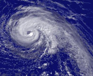
Hurricane Jeanne regional imagery, 2004.09.22 at 1945Z. Centerpoint Latitude: 26:13:30N Longitude: 70:06:12W.
Source: http://www.nnvl.noaa.gov/cgi-bin/index.cgi?page=items&ser=108310&large=1
Shortly after this image was taken the NHC quoted Dvorak T-Numbers of 5.0 from both the TAFB and SAB. [1]
References[編輯]
檔案歷史
點選日期/時間以檢視該時間的檔案版本。
| 日期/時間 | 縮圖 | 尺寸 | 使用者 | 備註 | |
|---|---|---|---|---|---|
| 目前 | 2006年8月24日 (四) 13:12 | | 188 × 154(63 KB) | Tropische Storm Sven~commonswiki(留言 | 貢獻) | ==Licensing== {{PD-USGov-DOC-NOAA}} ==Summary== Hurricane Jeanne regional imagery, 2004.09.22 at 1945Z. Centerpoint Latitude: 26:13:30N Longitude: 70:06:12W. Source: http://www.nnvl.noaa.gov/cgi-bin/index.cgi?page=items&ser=108310&large=1 Shortly after |
無法覆蓋此檔案。
檔案用途
沒有使用此檔案的頁面。
全域檔案使用狀況
以下其他 wiki 使用了這個檔案:
- ca.wikipedia.org 的使用狀況
- de.wikipedia.org 的使用狀況
- en.wikipedia.org 的使用狀況
- es.wikipedia.org 的使用狀況
- fr.wikipedia.org 的使用狀況
- ja.wikipedia.org 的使用狀況
- nl.wikipedia.org 的使用狀況
- pt.wikipedia.org 的使用狀況
- zh.wikipedia.org 的使用狀況