File:Jeanne-22-1945z-T50-discussion2100z.png
跳转到导航
跳转到搜索
没有更高的分辨率。
Jeanne-22-1945z-T50-discussion2100z.png (188 × 154像素,文件大小:63 KB,MIME类型:image/png)
说明
说明
添加一行文字以描述该文件所表现的内容
许可协议[编辑]
本图像属于公有领域,因该作品最初来自于美国国家海洋和大气管理局职员的职务作品。
|
摘要[编辑]
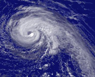
Hurricane Jeanne regional imagery, 2004.09.22 at 1945Z. Centerpoint Latitude: 26:13:30N Longitude: 70:06:12W.
Source: http://www.nnvl.noaa.gov/cgi-bin/index.cgi?page=items&ser=108310&large=1
Shortly after this image was taken the NHC quoted Dvorak T-Numbers of 5.0 from both the TAFB and SAB. [1]
References[编辑]
文件历史
点击某个日期/时间查看对应时刻的文件。
| 日期/时间 | 缩略图 | 大小 | 用户 | 备注 | |
|---|---|---|---|---|---|
| 当前 | 2006年8月24日 (四) 13:12 | | 188 × 154(63 KB) | Tropische Storm Sven~commonswiki(留言 | 贡献) | ==Licensing== {{PD-USGov-DOC-NOAA}} ==Summary== Hurricane Jeanne regional imagery, 2004.09.22 at 1945Z. Centerpoint Latitude: 26:13:30N Longitude: 70:06:12W. Source: http://www.nnvl.noaa.gov/cgi-bin/index.cgi?page=items&ser=108310&large=1 Shortly after |
您不可以覆盖此文件。
文件用途
没有页面使用本文件。
全域文件用途
以下其他wiki使用此文件:
- ca.wikipedia.org上的用途
- de.wikipedia.org上的用途
- en.wikipedia.org上的用途
- es.wikipedia.org上的用途
- fr.wikipedia.org上的用途
- ja.wikipedia.org上的用途
- nl.wikipedia.org上的用途
- pt.wikipedia.org上的用途
- zh.wikipedia.org上的用途