File:Joggins Cliffs, Nova Scotia.jpg
Zur Navigation springen
Zur Suche springen

Größe dieser Vorschau: 600 × 600 Pixel. Weitere Auflösungen: 240 × 240 Pixel | 480 × 480 Pixel | 768 × 768 Pixel | 1.024 × 1.024 Pixel | 2.048 × 2.048 Pixel | 3.000 × 3.000 Pixel.
Originaldatei (3.000 × 3.000 Pixel, Dateigröße: 4,64 MB, MIME-Typ: image/jpeg)
Bildtexte
Kurzbeschreibungen
Ergänze eine einzeilige Erklärung, was diese Datei darstellt.
Beschreibung[Bearbeiten]
| Beschreibung |
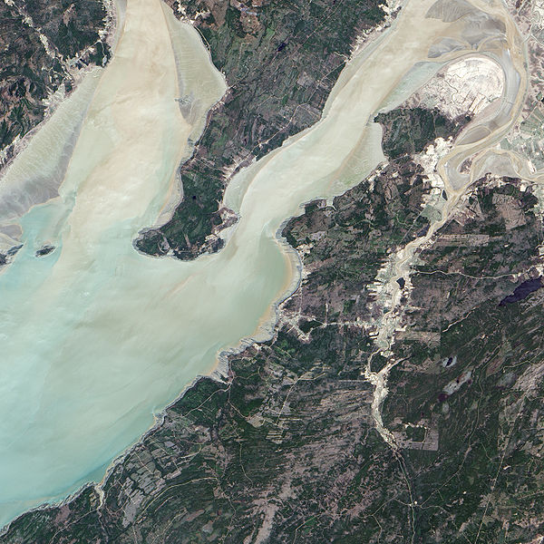
English: The Advanced Land Imager (ALI) on NASA’s Earth Observing-1 satellite captured this true-color image of the Joggins Fossil Cliffs region. The fossil cliffs trace a curving line through the middle of this image, with Cumberland Basin in the west and a small village in the east. Sunlight and sediment color the water of Cumberland Basin pastel. On land, colors vary from deep green vegetation to brown bare rock to gray paved surfaces. Roads cut crooked lines through the landscape. The cliffs appear gray-beige, giving way to buff color nearest the water. |
| Datum | |
| Quelle | NASA Earth Observatory |
| Urheber | Jesse Allen |
Instrument: EO-1 - ALI
Lizenz[Bearbeiten]
| Diese Datei ist gemeinfrei (public domain), da sie von der NASA erstellt worden ist. Die NASA-Urheberrechtsrichtlinie besagt, dass „NASA-Material nicht durch Urheberrecht geschützt ist, wenn es nicht anders angegeben ist“. (NASA-Urheberrechtsrichtlinie-Seite oder JPL Image Use Policy). | ||
 |
Warnung:
|
| Bildnotizen | Diese Datei ist annotiert: Betrachte diese auf Commons. |
Dateiversionen
Klicke auf einen Zeitpunkt, um diese Version zu laden.
| Version vom | Vorschaubild | Maße | Benutzer | Kommentar | |
|---|---|---|---|---|---|
| aktuell | 13:53, 23. Mai 2009 | | 3.000 × 3.000 (4,64 MB) | Originalwana (Diskussion | Beiträge) | {{Information |Description={{en|1=The Advanced Land Imager (ALI) on NASA’s Earth Observing-1 satellite captured this true-color image of the Joggins Fossil Cliffs region. The fossil cliffs trace a curving line through the middle of this image, with Cumb |
Du kannst diese Datei nicht überschreiben.
Dateiverwendung
Keine Seiten verwenden diese Datei.
Globale Dateiverwendung
Die nachfolgenden anderen Wikis verwenden diese Datei:
- Verwendung auf de.wikipedia.org
- Verwendung auf en.wikipedia.org
- Verwendung auf fr.wikipedia.org
- Verwendung auf hr.wikipedia.org
- Verwendung auf ru.wikipedia.org
- Verwendung auf sh.wikipedia.org
- Verwendung auf uk.wikipedia.org