File:Joh. Bapt. Homann - Geographische Vorstellung der jämerlichen Wasser-Flutt in Nieder-Teutschland.jpg
Originaldatei (6.920 × 5.840 Pixel, Dateigröße: 16,03 MB, MIME-Typ: image/jpeg)
Bildtexte
Kurzbeschreibungen
Beschreibung[Bearbeiten]
| Beschreibung |
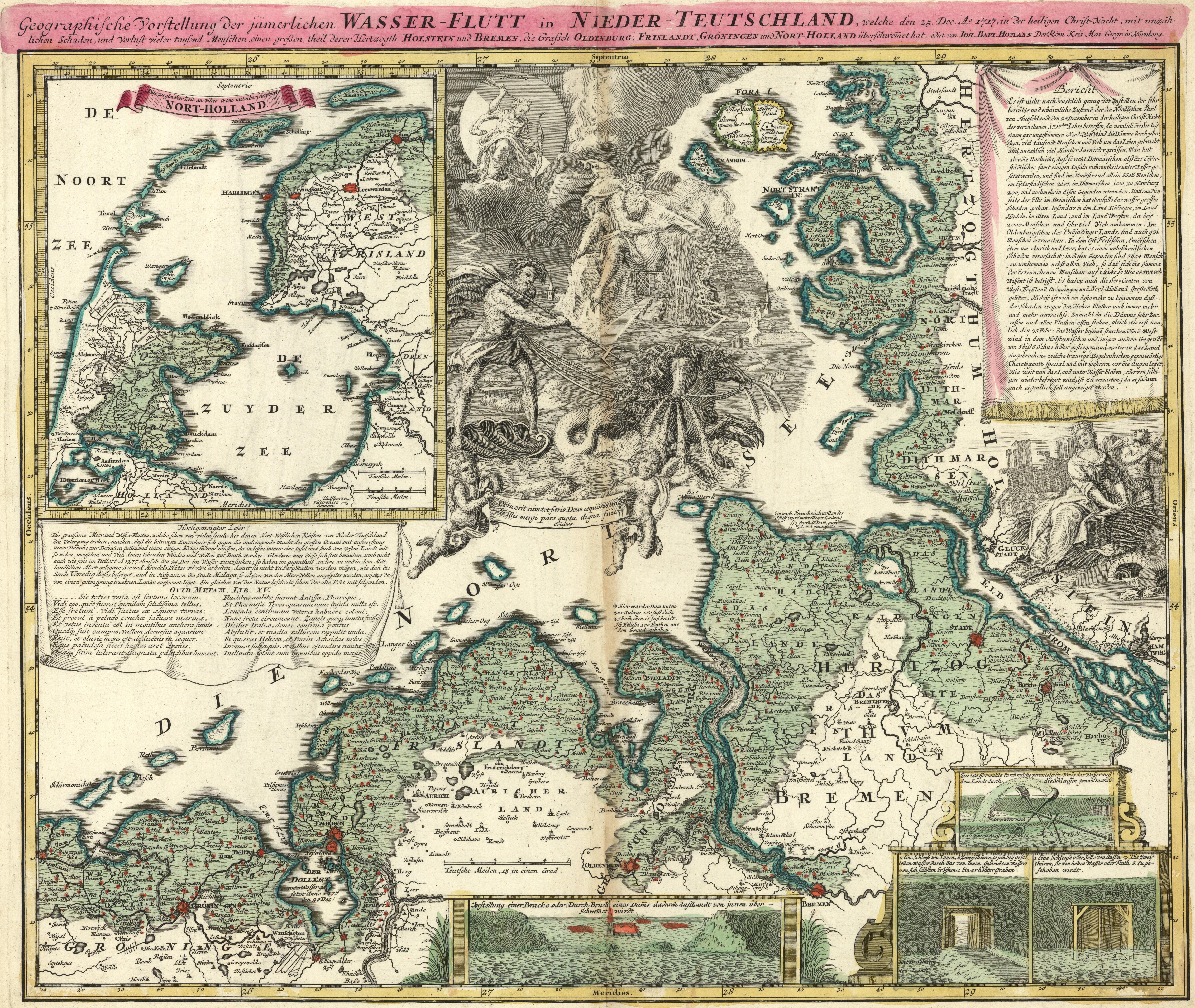
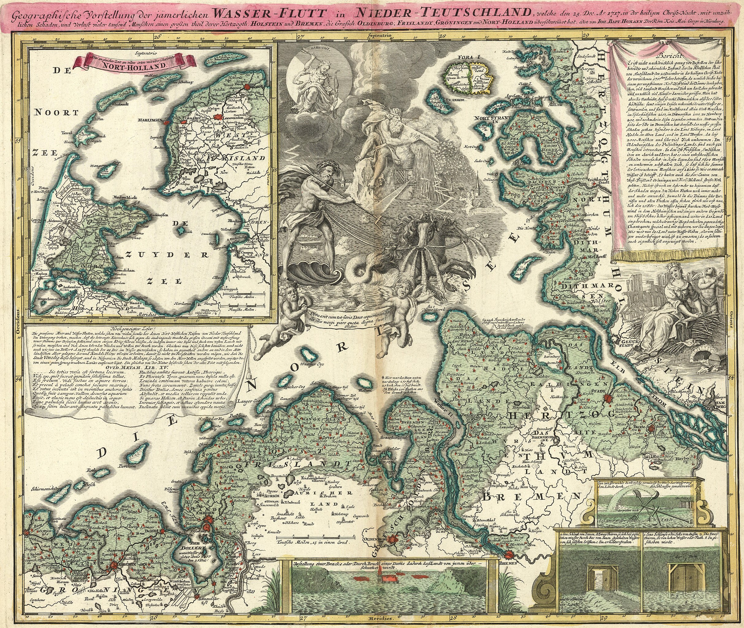
Nederlands: Kaart van Johann Baptist Homann uit 1720 van de Kerstvloed in een poging om de grenzen van de overstroomde gebieden weer te geven: De volledige titel luidt: Geographische Vorstellung der jämmerlichen WASSER-FLUTT in NIEDERTEUTSCHLAND, welche den 25.Dec. Ao. 1717, in der heiligen Christ-Nacht, mit unzählichen Schaden und Verlust vieler tausend Menschen einen großen theil derer Hertzogth. HOLSTEIN und BREMEN, die Grafsch. OLDENBURG, FRISLANDT, GRÖNINGEN und NORT-HOLLAND überschwemmet hat.
Vertaling: Geografische voorstelling van de jammerlijke watervloed in Neder-Duitsland, die op 25 december 1717, tijdens Kerstnacht, met ontzagwekkende schade en verlies van vele duizenden mensenlevens een groot deel van het Hertogdom Holstein en Bremen, het Graafschap Oldenburg, Friesland, Groningen en Noord-Holland heeft overstroomd. De kaart geeft een globaal beeld. Lang niet alle grenzen klopten precies met de werkelijkheid. |
|||||||||||||||||||||||
| Datum | ||||||||||||||||||||||||
| Quelle | Beeldbank Groningen | |||||||||||||||||||||||
| Urheber |
|
|||||||||||||||||||||||
| Andere Versionen |
|
|||||||||||||||||||||||
.jpg)


Lizenz[Bearbeiten]
|
Dieses Werk ist gemeinfrei, weil seine urheberrechtliche Schutzfrist abgelaufen ist. Dieses Werk ist gemeinfrei in den Vereinigten Staaten, weil es vor dem 1. Januar 1929 veröffentlicht (oder beim U.S. Copyright Office registriert) wurde. | |
| Es wurde festgestellt, dass diese Datei frei von bekannten Beschränkungen durch das Urheberrecht ist, alle verbundenen und verwandten Rechte eingeschlossen. | |
Dateiversionen
Klicke auf einen Zeitpunkt, um diese Version zu laden.
| Version vom | Vorschaubild | Maße | Benutzer | Kommentar | |
|---|---|---|---|---|---|
| aktuell | 16:30, 22. Dez. 2017 | | 6.920 × 5.840 (16,03 MB) | Hardscarf (Diskussion | Beiträge) | User created page with UploadWizard |
Du kannst diese Datei nicht überschreiben.
Dateiverwendung
Die folgenden 5 Seiten verwenden diese Datei:
Globale Dateiverwendung
Die nachfolgenden anderen Wikis verwenden diese Datei:
- Verwendung auf de.wikipedia.org
- Verwendung auf en.wikipedia.org
- Verwendung auf nds.wikipedia.org
- Verwendung auf nl.wikipedia.org
- Verwendung auf www.wikidata.org
Metadaten
- Christmas flood 1717
- Old weather and climate maps
- 1720 maps
- Maps of weather in 1717
- Maps of floods
- Maps of weather and climate of Denmark
- 1720s maps of Denmark
- Old maps of Lower Saxony
- Lower Saxony in the 1710s
- Old maps of Schleswig-Holstein
- 1720s maps of Germany
- 1720s maps of the Netherlands
- Maps of weather events in the Netherlands
- Hydrographic maps of the Netherlands
- Maps of the Dollard