File:Joint Security Area 1976 map.jpg
跳至導覽
跳至搜尋

預覽大小:676 × 599 像素。 其他解析度:271 × 240 像素 | 541 × 480 像素 | 758 × 672 像素。
原始檔案 (758 × 672 像素,檔案大小:96 KB,MIME 類型:image/jpeg)
說明
說明
添加單行說明來描述出檔案所代表的內容
摘要
[編輯]
| 描述 |
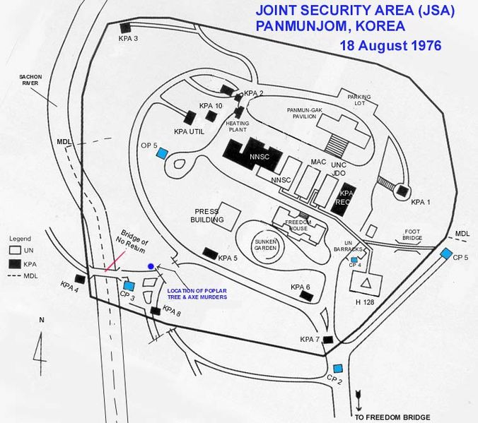
English: A map showing the layout (and names) of the various buildings within the Joint Security Area.
Legend: CP - Check Point KPA - Korean People's Army MAC - Military Armistice Commission MDL - Military Demarcation Line NNSC - Neutral Nations Supervisory Commission OP - Observation Post UNC - United Nations Command |
| 日期 |
|
| 來源 | Transferred from en.wikipedia by SreeBot |
| 作者 | Wbfergus at en.wikipedia |
授權條款
[編輯]
此作品在美國屬於公有領域,因為其是由美國政府的官員或僱員,基於其個人公務目的製作的作品,參考美國法典第17篇第1章第105條。
注意︰本模板僅適用於美國聯邦政府的原創作品,不適用於任何美國州、屬地、聯邦個體、縣、市或任何次級政府的作品。本模板也不適用於1978年以後由美國郵政署出版的郵票圖案(參看美國版權局實踐綱領第313.6(C)(1)條)。也不適用於部分美國硬幣;參看美國鑄幣局使用條款。 |
 | |
| 此作品無已知的著作權限制,亦不受所有相關和鄰接的權利限制。 | ||
原始上傳日誌
[編輯]
The original description page was here. All following user names refer to en.wikipedia.
Upload date | User | Bytes | Dimensions | Comment
- 2006-11-27 19:40 (UTC) | Wbfergus | 98352 (bytes) | 758×672 | A map showing the layout (and names) of the various buildings within the Joint Security Area.
檔案歷史
點選日期/時間以檢視該時間的檔案版本。
| 日期/時間 | 縮圖 | 尺寸 | 用戶 | 備註 | |
|---|---|---|---|---|---|
| 目前 | 2011年8月5日 (五) 21:24 | | 758 × 672(96 KB) | SreeBot(對話 | 貢獻) |
無法覆蓋此檔案。
檔案用途
下列頁面有用到此檔案:
全域檔案使用狀況
以下其他 wiki 使用了這個檔案:
- ar.wikipedia.org 的使用狀況
- de.wikipedia.org 的使用狀況
- en.wikipedia.org 的使用狀況
- es.wikipedia.org 的使用狀況
- fr.wikipedia.org 的使用狀況
- it.wikipedia.org 的使用狀況
- ko.wikipedia.org 的使用狀況
- nl.wikipedia.org 的使用狀況
- ru.wikipedia.org 的使用狀況
- sv.wikipedia.org 的使用狀況
- zh.wikipedia.org 的使用狀況