File:Junction fault 0112.jpg
跳转到导航
跳转到搜索

本预览的尺寸:800 × 600像素。 其他分辨率:320 × 240像素 | 640 × 480像素 | 1,024 × 768像素 | 1,280 × 960像素 | 2,560 × 1,920像素。
原始文件 (2,560 × 1,920像素,文件大小:3.88 MB,MIME类型:image/jpeg)
说明
说明
添加一行文字以描述该文件所表现的内容
摘要
[编辑]
| 描述 |
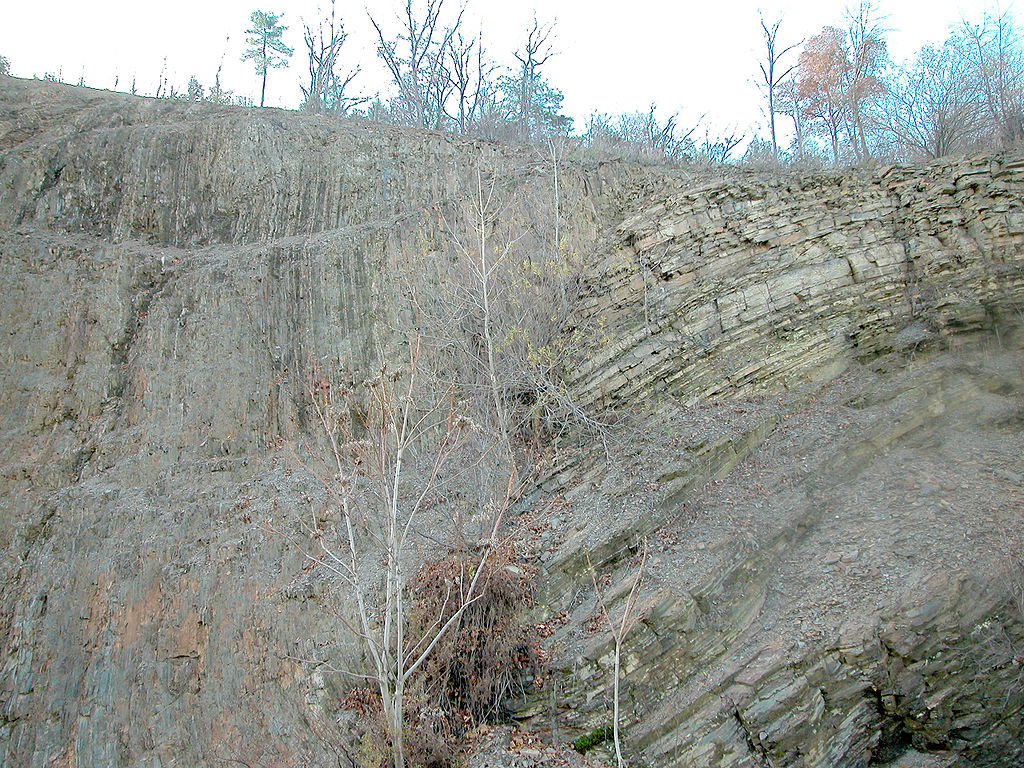
English: Dividing fault between Appalachian Mountains and Allegheny Plateau. A major geologic fault (directly behind small trees) can be seen in a new roadcut about 6 miles north of en:Williamsport, Pennsylvania on new Route 15. The fault is just about at the line that divides the folded en:Appalachian Mountains and the merely uplifted en:dissected plateau of the en:Allegheny Plateau. On the left hand (south side) is metamorphic rock. On the right hand is en:sedimentary rock, which, as one continues northward becomes mostly horizontal.
Image copyleft: Image taken by me, released under GFDL, Pollinator 06:08, Dec 25, 2004 (UTC) |
| 日期 | 2004年12月25日 (原始上传日期) |
| 来源 | 本檔案是從en.wikipedia轉移到維基共享資源。 |
| 作者 | 英语维基百科的Pollinator |
| 相机位置 | | 在以下服务上查看本图像和附近其他图像: OpenStreetMap |
|---|
许可协议
[编辑]
| 本文件采用知识共享署名-相同方式共享 3.0 未本地化版本许可协议授权。 受免責聲明的約束。 | ||
| ||
| 本许可协议标签作为GFDL许可协议更新的组成部分被添加至本文件。 |

|
已授权您依据自由软件基金会发行的无固定段落及封面封底文字(Invariant Sections, Front-Cover Texts, and Back-Cover Texts)的GNU自由文件许可协议1.2版或任意后续版本的条款,复制、传播和/或修改本文件。该协议的副本请见“GNU Free Documentation License”。 受免責聲明的約束。 |
原始上传日志
[编辑]
原始描述頁面位於這裡。下列使用者名稱均來自en.wikipedia。
- 2004-12-25 06:01 Pollinator 2560×1920×8 (4068378 bytes) Dividing fault between Appalachian Mountains and Allegheny Plateau
文件历史
点击某个日期/时间查看对应时刻的文件。
| 日期/时间 | 缩略图 | 大小 | 用户 | 备注 | |
|---|---|---|---|---|---|
| 当前 | 2007年12月17日 (一) 10:08 | | 2,560 × 1,920(3.88 MB) | File Upload Bot (Magnus Manske)(留言 | 贡献) | {{BotMoveToCommons|en.wikipedia}} {{Information |Description={{en|Dividing fault between Appalachian Mountains and Allegheny Plateau A major geologic fault (directly behind small trees) can be seen in a new roadcut about 10 miles north of [[:en:Williams |
您不可以覆盖此文件。
文件用途
没有页面使用本文件。
全域文件用途
以下其他wiki使用此文件:
- en.wikipedia.org上的用途
- eo.wikipedia.org上的用途
- es.wikipedia.org上的用途
- fr.wikipedia.org上的用途
- gl.wikipedia.org上的用途
- id.wikipedia.org上的用途
- it.wikipedia.org上的用途
- ja.wikipedia.org上的用途
- sl.wikipedia.org上的用途
- th.wikipedia.org上的用途
- zh.wikipedia.org上的用途