File:KPA3-2a.jpg
跳至導覽
跳至搜尋

預覽大小:800 × 499 像素。 其他解析度:320 × 200 像素 | 640 × 399 像素 | 832 × 519 像素。
原始檔案 (832 × 519 像素,檔案大小:117 KB,MIME 類型:image/jpeg)
說明
說明
添加單行說明來描述出檔案所代表的內容
摘要[編輯]
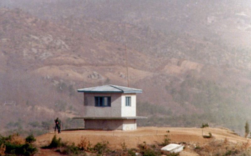
| 描述 | Another view of KPA#3. The North Korean boundary of the DMZ is clearly visible in the background. The clear area, which is on the south side of a fence, is the North Korean's minefield. The dirt is checked each day for any signs of footprints or other disturbances. (Photo January 1976) |
| 日期 | 2007年1月7日 (原始上傳日期) |
| 來源 | 无法识别来源。根据版权声明推断为其自己的作品。 |
| 作者 | 无法识别作者。根据版权声明推断作者为Wbfergus。 |
授權條款[編輯]
| 我,此作品的版權所有人,釋出此作品至公共領域。此授權條款在全世界均適用。 這可能在某些國家不合法,如果是的話: 我授予任何人有權利使用此作品於任何用途,除受法律約束外,不受任何限制。 |
檔案歷史
點選日期/時間以檢視該時間的檔案版本。
| 日期/時間 | 縮圖 | 尺寸 | 使用者 | 備註 | |
|---|---|---|---|---|---|
| 目前 | 2012年4月24日 (二) 19:32 | | 832 × 519(117 KB) | Hohum(留言 | 貢獻) | Reworked from original. |
| 2009年10月5日 (一) 19:17 |  | 835 × 518(106 KB) | Smurfy(留言 | 貢獻) | Cropped, straightened, colour corrected and cleaned up. | |
| 2007年1月7日 (日) 17:58 |  | 900 × 604(120 KB) | Wbfergus(留言 | 貢獻) | Another view of KPA#3. The North Korean boundary of the DMZ is clearly visible in the background. The clear area, which is on the south side of a fence, is the North Korean's minefield. The dirt is checked each day for any signs of footprints or other dis |
無法覆蓋此檔案。
檔案用途
下列頁面有用到此檔案:
全域檔案使用狀況
以下其他 wiki 使用了這個檔案:
- bg.wikipedia.org 的使用狀況
- en.wikipedia.org 的使用狀況
- it.wikipedia.org 的使用狀況
- no.wikipedia.org 的使用狀況
- simple.wikipedia.org 的使用狀況
- zh.wikipedia.org 的使用狀況