File:Kangshung-06.PNG
Ir a la navegación
Ir a la búsqueda

Tamaño de esta previsualización: 800 × 526 píxeles. Otras resoluciones: 320 × 210 píxeles | 640 × 421 píxeles | 1157 × 761 píxeles.
Archivo original (1157 × 761 píxeles; tamaño de archivo: 1,95 MB; tipo MIME: image/png)
Leyendas
Leyendas
Añade una explicación corta acerca de lo que representa este archivo
Resumen
[editar]| Descripción |
Deutsch: Ost- (Kangshung-) Wand des Mount Everest mit Umgebung |
|
| Fecha | 12 de noviembre de 2008 (fecha original de carga) | |
| Fuente | Transferido desde de.wikipedia a Commons por Rupert Pupkin usando CommonsHelper. | |
| Autor |
Fotografía: NASA |
|
| Otras versiones |
|


Notes
[editar]
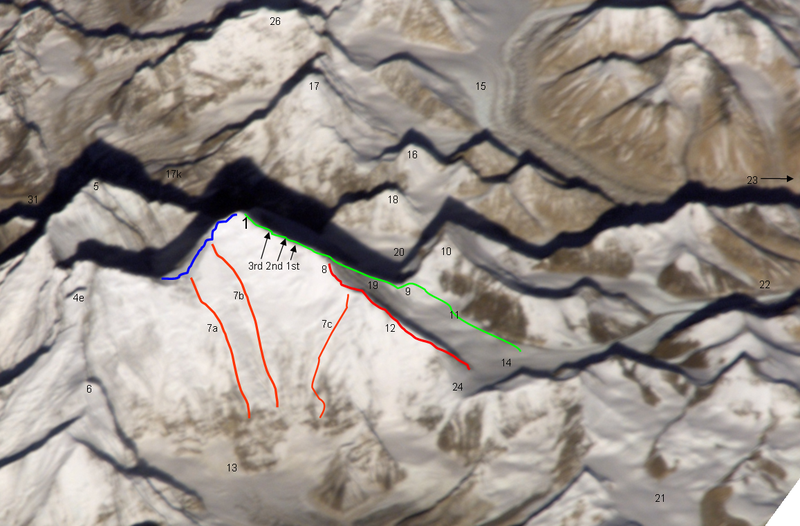
| green line | Normal route, mainly the Mallory route 1924, via high camps on 7700 and 8300 m, via "yellow band", exit cracks & upper NE ridge w. "Second Step") |
| red line / no.12 | lower and middle NE ridge |
| blue line | upper SE ridge (part of the «Hillary route» 1953 etc. coming from Western Qwm (in the shadow behind Mt. Everest) meeting point with the orange route 7a is the south col meeting point with the orange route 7b is the balcony |
| orange line 7a | 1988 US and GB ascent (Stephen Vernables et al.) |
| orange line 7b | 1982 US ascent (Carlos Buhler, Kim Momb et al.) |
| orange line 7c | “Phantasy Ridge” (acc. to a speech of George Mallory), no successful ascent until 2008, tried by Cathy O’Dowd and Ian Woodall; they came half way to NE ridge & Pinnacles |
| 1 | summit of Mount Everest 8848m |
| 3rd 2nd 1st | steps on the Upper NE ridge 8700m, 8605m and 8530m |
| 4e | Lhotse Shar |
| 5 | Nuptse |
| 6 | “Peak 38” |
| 13 | Kangshung Glacier |
| 8 | “Three Pinnacles” where Joe Tasker and Peter Boardman died 1982 (2nd pinnacle) |
| 9 | North Col on 7050m |
| 14 | East Rongbuk Glacier |
| 10 | Changtse (northern summit) |
| 11 | ABC Advanced Base Camp (North) on the upper East Rongbuk Glacier in front of the ice wall to north col |
| 15 | West Rongbuk Glacier (coming from the Cho Oyu and Gyachung Kang flanks) |
| 16 | Lingtren |
| 17 | Pumori |
| 17k | Kala Patthar, “Everest Trekking View Point” from the south side |
| 18 | Khumbutse (summit west of Lho La which is the connection on 6006m of the glacier systems of Rongbu and Khumbu and is also the tibetian-nepalian borderline / like SE ridge & W ridge. Lho La is "foot point" of the Everest W ridge.) |
| 19 | north ridge // below of fig. 19 the Zakharov Couloir offering a tough ascent to NE ridge without going via north col |
| 20 | Main Rongbuk Glacier |
| 21 | upper Kharta Glacier (Mallory 1921, where discovered the access to North Col) |
| 22 | Camp II of the early british expeditions 1922+1924 |
| 23 | to the Base camp on foot of the Main Rongbuk Glacier and to Rongbuk Gompa (Monastery) |
| 24 | Rapiu La (connection from Eastern Rongbuk Glacier System to Kangshung Glacier System) |
Licencia
[editar]
Original photograph:
| Este archivo es de dominio público porque fue creado por la NASA. Las políticas sobre copyright de la NASA estipulan que «el material de la NASA no está protegido con copyright a menos que se indique lo contrario». (Políticas sobre copyright de la NASA o Políticas sobre la utilización de imágenes del Jet Propulsion Laboratory). |
Lines and points:
Kassander der Minoer de Wikipedia en alemán, titular de los derechos de autor de esta obra, la publica en los términos de la siguiente licencia:

|
Se autoriza la copia, distribución y modificación de este documento bajo los términos de la licencia de documentación libre GNU, versión 1.2 o cualquier otra que posteriormente publique la Fundación para el Software Libre; sin secciones invariables, textos de portada, ni textos de contraportada. Se incluye una copia de la dicha licencia en la sección titulada Licencia de Documentación Libre GNU. |
| Este archivo se encuentra bajo la licencia Creative Commons Genérica de Atribución/Compartir-Igual 3.0. | ||
| Atribución: Kassander der Minoer de Wikipedia en alemán | ||
| ||
| Esta etiqueta de licencia fue agregada a este archivo como parte de la actualización de la licencia GFDL. |
Registro original de carga
[editar]
Aquí se muestra la página de descripción original. Los siguientes nombres de usuario se refieren a de.wikipedia.
- 2008-11-12 20:39 Kassander der Minoer 1157×761× (2046200 bytes) {{Information |Beschreibung = Ost- (Kangshung-) Wand des Mount Everest mit Umgebung |Quelle = NASA & eigene Arbeit (Linien und Punkte markiert) |Urheber = NASA |Datum = 12.11.2008 |Genehmigung = US-Gov-GFDL |Andere Versionen = |Anmerkungen = }}
Historial del archivo
Haz clic sobre una fecha y hora para ver el archivo tal como apareció en ese momento.
| Fecha y hora | Miniatura | Dimensiones | Usuario | Comentario | |
|---|---|---|---|---|---|
| actual | 21:59 26 nov 2008 | | 1157 × 761 (1,95 MB) | File Upload Bot (Magnus Manske) (discusión | contribs.) | {{BotMoveToCommons|de.wikipedia}} {{Information |Description={{de|Ost- (Kangshung-) Wand des Mount Everest mit Umgebung}} |Source=Transferred from [http://de.wikipedia.org de.wikipedia]; transferred to Commons by User:Rupert Pupkin using [http://tool |
No puedes sobrescribir este archivo.
Usos del archivo
Las siguientes páginas usan este archivo:
.jpg)
Uso global del archivo
Las wikis siguientes utilizan este archivo:
- Uso en az.wikipedia.org
- Uso en bs.wikipedia.org
- Uso en de.wikipedia.org
- Uso en en.wikipedia.org
- Uso en es.wikipedia.org
- Uso en fr.wikipedia.org
- Uso en ro.wikipedia.org
- Uso en ru.wikipedia.org
- Uso en uk.wikipedia.org
- Uso en www.wikidata.org
- Uso en zh.wikipedia.org