File:Kaohsiung City Map 2022-3-18.jpg
跳至導覽
跳至搜尋

預覽大小:500 × 599 像素。 其他解析度:200 × 240 像素 | 401 × 480 像素 | 641 × 768 像素 | 855 × 1,024 像素 | 1,710 × 2,048 像素 | 6,572 × 7,872 像素。
原始檔案 (6,572 × 7,872 像素,檔案大小:2.72 MB,MIME 類型:image/jpeg)
說明
說明
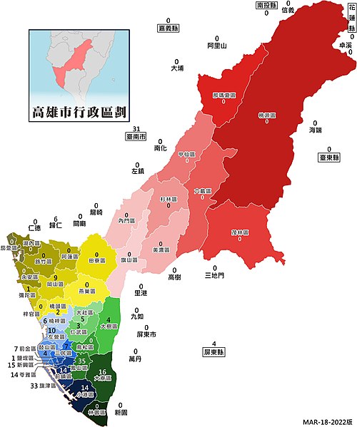
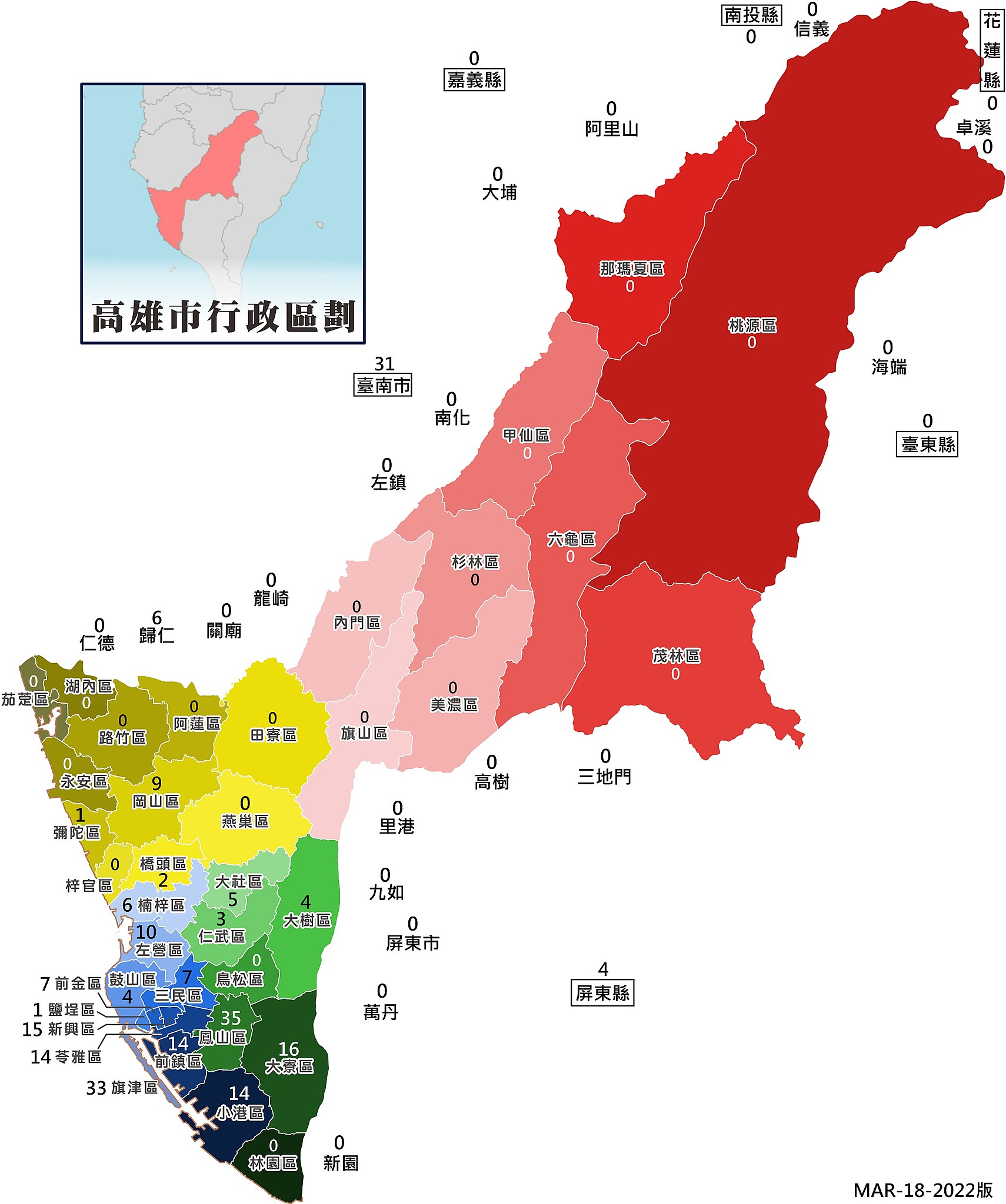
高雄市各地區確診總累計數統計 (2022年1月20日起至3月16日止)
摘要
[編輯]
| 描述 |
English: Statistics on the cumulative number of confirmed cases in various regions of Kaohsiung City (from January 20 to March 16, 2022) |
| 日期 | |
| 來源 | 自己的作品 |
| 作者 | My022822 |
授權條款
[編輯]
我,本作品的著作權持有者,決定用以下授權條款發佈本作品:
此檔案採用創用CC 姓名標示-相同方式分享 4.0 國際授權條款。
- 您可以自由:
- 分享 – 複製、發佈和傳播本作品
- 重新修改 – 創作演繹作品
- 惟需遵照下列條件:
- 姓名標示 – 您必須指名出正確的製作者,和提供授權條款的連結,以及表示是否有對內容上做出變更。您可以用任何合理的方式來行動,但不得以任何方式表明授權條款是對您許可或是由您所使用。
- 相同方式分享 – 如果您利用本素材進行再混合、轉換或創作,您必須基於如同原先的相同或兼容的條款,來分布您的貢獻成品。
檔案歷史
點選日期/時間以檢視該時間的檔案版本。
| 日期/時間 | 縮圖 | 尺寸 | 使用者 | 備註 | |
|---|---|---|---|---|---|
| 目前 | 2022年3月18日 (五) 07:15 | | 6,572 × 7,872(2.72 MB) | My022822(留言 | 貢獻) | Uploaded own work with UploadWizard |
無法覆蓋此檔案。
檔案用途
下列38個頁面有用到此檔案:
- 高雄市
- Category:Artificial lakes in Kaohsiung
- Category:Beaches of Kaohsiung
- Category:Births in Kaohsiung
- Category:Bridges in Kaohsiung
- Category:Cliffs of Kaohsiung
- Category:Coastal erosion in Kaohsiung
- Category:Coasts of Kaohsiung
- Category:Education in Kaohsiung
- Category:Elections in Kaohsiung
- Category:Emperor Guan temples in Kaohsiung
- Category:Erosion in Kaohsiung
- Category:Geology of Kaohsiung
- Category:Hospitals in Kaohsiung
- Category:Kaohsiung
- Category:Lakes of Kaohsiung
- Category:Landforms of Kaohsiung
- Category:Maps of Kaohsiung
- Category:Mountains of Kaohsiung
- Category:Outcrops in Kaohsiung
- Category:People of Kaohsiung
- Category:Provincial highways in Kaohsiung
- Category:Religion in Kaohsiung
- Category:Reservoirs in Kaohsiung
- Category:Roads in Kaohsiung City
- Category:Rock formations in Kaohsiung
- Category:Rocks in Kaohsiung
- Category:Sports in Kaohsiung
- Category:Stone sculptures in Kaohsiung
- Category:Stratigraphy of Kaohsiung
- Category:Structural geology of Kaohsiung
- Category:Temples in Kaohsiung
- Category:Train stations in Kaohsiung
- Category:Tunnels in Kaohsiung
- Category:Views of Kaohsiung
- Category:Visitor attractions in Kaohsiung
- Category:Wangyeh temples in Kaohsiung
- Category:Water wells in Kaohsiung
全域檔案使用狀況
以下其他 wiki 使用了這個檔案:
- www.wikidata.org 的使用狀況
- zh.wikipedia.org 的使用狀況