File:Karoo ecoregion.jpg
Aller à la navigation
Aller à la recherche
Pas de plus haute résolution disponible.
Karoo_ecoregion.jpg (644 × 496 pixels, taille du fichier : 114 kio, type MIME : image/jpeg)
Légendes
Légendes
Ajoutez en une ligne la description de ce que représente ce fichier
Description[modifier]
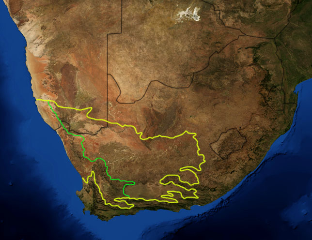
| Description | This is a map showing the location of the two Karoo ecoregions of southern Africa, as delineated by the World Wide Fund for Nature. The yellow line encloses the two ecoregions. The green line separates the Succulent Karoo, on the west, from the Nama Karoo, on the east. National boundaries are shown in black. I, Pfly, made it using NASA Blue Marble imagery and ecoregion GIS data which I simplified and digitized in Photoshop. |
| Date | |
| Source | NASA, plus my additions by myself. |
| Auteur | Pfly |
Conditions d’utilisation[modifier]
| Ce fichier provient de la NASA. Sauf exception, les documents créés par la NASA ne sont pas soumis à copyright. Pour plus d'informations, voir la politique de copyright de la NASA. | ||
 |
Attention :
|
Historique du fichier
Cliquer sur une date et heure pour voir le fichier tel qu'il était à ce moment-là.
| Date et heure | Vignette | Dimensions | Utilisateur | Commentaire | |
|---|---|---|---|---|---|
| actuel | 19 janvier 2007 à 20:29 | | 644 × 496 (114 kio) | Pfly (d | contributions) | {{Information |Description=This is a map showing the location of the two Karoo ecoregions of southern Africa, as delineated by the World Wide Fund for Nature. The yellow line encloses the two ecoregions. Th |
Vous ne pouvez pas remplacer ce fichier.
Utilisations locales du fichier
Aucune page n’utilise ce fichier.
Utilisations du fichier sur d’autres wikis
Les autres wikis suivants utilisent ce fichier :
- Utilisation sur af.wikipedia.org
- Utilisation sur bg.wikipedia.org
- Utilisation sur ca.wikipedia.org
- Utilisation sur de.wikipedia.org
- Utilisation sur en.wikipedia.org
- Utilisation sur eo.wikipedia.org
- Utilisation sur es.wikipedia.org
- Utilisation sur fi.wikipedia.org
- Utilisation sur frr.wikipedia.org
- Utilisation sur fr.wikipedia.org
- Utilisation sur fr.wiktionary.org
- Utilisation sur gl.wikipedia.org
- Utilisation sur hu.wikipedia.org
- Utilisation sur it.wikipedia.org
- Utilisation sur ja.wikipedia.org
- Utilisation sur ka.wikipedia.org
- Utilisation sur ko.wikipedia.org
- Utilisation sur lt.wikipedia.org
- Utilisation sur nl.wikipedia.org
- Utilisation sur no.wikipedia.org
- Utilisation sur pt.wikipedia.org
- Utilisation sur ru.wikipedia.org
- Utilisation sur sv.wikipedia.org
- Utilisation sur sw.wikipedia.org
- Utilisation sur tr.wikipedia.org