File:Karst peaks with sea of clouds at sunrise, South view from the top of Mount Nam Xay, Vang Vieng, Laos.jpg
跳至導覽
跳至搜尋
預覽大小:800 × 533 像素。 其他解析度:320 × 213 像素 | 640 × 427 像素 | 1,024 × 683 像素 | 1,280 × 853 像素 | 2,560 × 1,707 像素 | 6,129 × 4,086 像素。
原始檔案 (6,129 × 4,086 像素,檔案大小:6.4 MB,MIME 類型:image/jpeg)
說明
說明
添加單行說明來描述出檔案所代表的內容
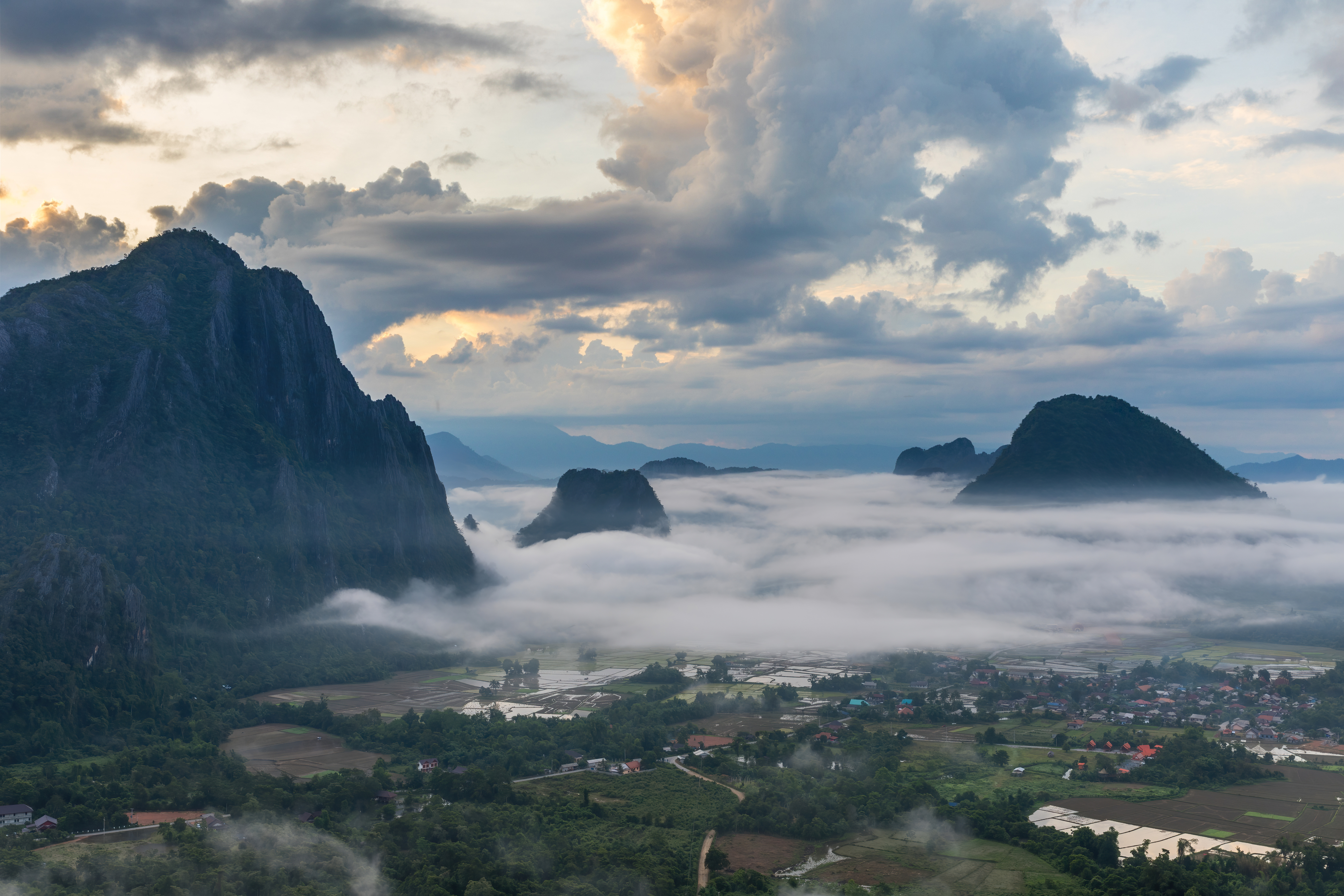
Karst peaks with sea of clouds at sunrise, South view from the top of Mount Nam Xay, Vang Vieng, Laos
摘要
[編輯]
| 描述 |
English: Karst peaks with colorful clouds above and sea of clouds below, covering the rice fields, at sunrise, South view from the top of Mount Nam Xay, during the monsoon, in Vang Vieng, Vientiane Province, Laos.
Français : Pitons karstiques au lever du soleil, avec des nuages colorés au-dessus et une mer de nuages au-dessous, recouvrant les rizières inondées, vue sud depuis le sommet du Mont Nam Xay, durant la mousson, à Vang Vieng, Province de Vientiane, Laos. |
| 日期 | |
| 來源 | 自己的作品 |
| 作者 | Basile Morin |
| 拍攝地點 | | 位於此地的本圖片與其他圖片: OpenStreetMap |
|---|
|
授權條款
[編輯]
我,本作品的著作權持有者,決定用以下授權條款發佈本作品:
此檔案採用創用CC 姓名標示-相同方式分享 4.0 國際授權條款。
- 您可以自由:
- 分享 – 複製、發佈和傳播本作品
- 重新修改 – 創作演繹作品
- 惟需遵照下列條件:
- 姓名標示 – 您必須指名出正確的製作者,和提供授權條款的連結,以及表示是否有對內容上做出變更。您可以用任何合理的方式來行動,但不得以任何方式表明授權條款是對您許可或是由您所使用。
- 相同方式分享 – 如果您利用本素材進行再混合、轉換或創作,您必須基於如同原先的相同或兼容的條款,來分布您的貢獻成品。
檔案歷史
點選日期/時間以檢視該時間的檔案版本。
| 日期/時間 | 縮圖 | 尺寸 | 使用者 | 備註 | |
|---|---|---|---|---|---|
| 目前 | 2021年2月19日 (五) 00:12 | | 6,129 × 4,086(6.4 MB) | Basile Morin(留言 | 貢獻) | Minor improvement : blown highlights dialed down at the upper left corner |
| 2020年8月9日 (日) 09:30 |  | 6,129 × 4,086(5.85 MB) | Basile Morin(留言 | 貢獻) | Uploaded own work with UploadWizard |
無法覆蓋此檔案。
檔案用途
下列19個頁面有用到此檔案:
- User:Derbeth/Various favs
- User:Dronebogus/Favorites
- User:Firefly/2020-B
- User:Meiræ/21
- User:Nardog/PotY
- User talk:Basile Morin/Archive 7 (2020)
- Commons:Featured picture candidates/File:Karst peaks with sea of clouds at sunrise, South view from the top of Mount Nam Xay, Vang Vieng, Laos.jpg
- Commons:Featured picture candidates/Log/December 2020
- Commons:Featured pictures/Natural phenomena
- Commons:Featured pictures/chronological/2020-B
- Commons:Featured pictures/chronological/December 2020
- Commons:Picture of the Year/2020/Candidates
- Commons:Picture of the Year/2020/R1/Gallery/2020-B
- Commons:Picture of the Year/2020/R1/Gallery/ALL
- Commons:Picture of the Year/2020/R1/Gallery/M12
- Commons:Picture of the Year/2020/R1/Gallery/Settlements
- Commons:Picture of the Year/2020/R1/v/Karst peaks with sea of clouds at sunrise, South view from the top of Mount Nam Xay, Vang Vieng, Laos.jpg
- Commons:Quality images/Subject/Sunsets
- Commons:Quality images candidates/Archives August 12 2020
全域檔案使用狀況
以下其他 wiki 使用了這個檔案:
- bcl.wiktionary.org 的使用狀況
- bn.wikibooks.org 的使用狀況
- de.wikipedia.org 的使用狀況
- en.wikipedia.org 的使用狀況
- Vang Vieng
- Wikipedia:Featured pictures/Places/Urban
- Talk:Vang Vieng
- User talk:Basile Morin
- User:Basile Morin
- Wikipedia:Featured picture candidates/February-2021
- Wikipedia:Featured picture candidates/Karst peaks with sea of clouds at sunrise, Vang Vieng, Laos
- Wikipedia:Featured pictures thumbs/70
- Wikipedia:Picture of the day/November 2023
- Template:POTD/2023-11-16
- User talk:TheFreeWorld/Archive 1
- fa.wikibooks.org 的使用狀況
- fr.wikipedia.org 的使用狀況
- hy.wikibooks.org 的使用狀況
- lb.wikipedia.org 的使用狀況
- uk.wikipedia.org 的使用狀況
- www.wikidata.org 的使用狀況
- zh.wikipedia.org 的使用狀況