File:Karta FP Austral isl.PNG
跳去導覽
跳去搵嘢
冇更高解像度嘅圖像。
Karta_FP_Austral_isl.PNG (450 × 400 像素,檔案大細:5 KB ,MIME類型:image/png)
Captions
Captions
Add a one-line explanation of what this file represents
摘要[編輯]
| 描述 |
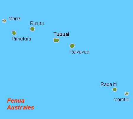
Deutsch: Karte der Australinseln, Französisch Polynesien
English: Map (rough) of the Austral Islands, French Polynesia, own work composed from various mapreferences
Svenska: Karta över Australöarna, FP |
| 日期 | |
| 來源 | 自己作品 |
| 作者 | Hobe / Holger Behr |
| Other versions | Macedonian version |
協議[編輯]
| I, the copyright holder of this work, release this work into the public domain. This applies worldwide. In some countries this may not be legally possible; if so: I grant anyone the right to use this work for any purpose, without any conditions, unless such conditions are required by law. |
檔案歷史
撳個日期/時間去睇響嗰個時間出現過嘅檔案。
| 日期/時間 | 縮圖 | 尺寸 | 用戶 | 註解 | |
|---|---|---|---|---|---|
| 現時 | 2012年9月29號 (六) 10:38 | | 450 × 400(5 KB) | Koumz(傾偈 | 貢獻) | trying to revert hoax change to file |
| 2012年9月29號 (六) 10:33 |  | 450 × 400(5 KB) | Koumz(傾偈 | 貢獻) | rv hoax | |
| 2012年9月29號 (六) 10:32 |  | 450 × 400(5 KB) | Koumz(傾偈 | 貢獻) | rv hoax | |
| 2012年9月29號 (六) 10:30 |  | 450 × 400(5 KB) | Koumz(傾偈 | 貢獻) | rv hoax | |
| 2012年9月28號 (五) 16:25 |  | 450 × 400(5 KB) | Human anatomy(傾偈 | 貢獻) | нова държава | |
| 2009年7月2號 (四) 09:05 |  | 450 × 400(5 KB) | Telim tor(傾偈 | 貢獻) | + Maria Atoll at the correct position | |
| 2008年10月10號 (五) 08:17 |  | 450 × 400(4 KB) | Telim tor(傾偈 | 貢獻) | uploaded version without "Maria" wich was definitely at the wrong place. The atoll Maria is not shown on this map. | |
| 2007年4月21號 (六) 12:57 |  | 450 × 400(4 KB) | Hobe(傾偈 | 貢獻) | karta Australöarna FP, Holger behr, own work |
你無得衾咗個檔案。
檔案用途
無頁面用到呢個檔案。
全域檔案使用情況
下面嘅維基都用緊呢個檔案:
- af.wikipedia.org嘅使用情況
- ar.wikipedia.org嘅使用情況
- az.wikipedia.org嘅使用情況
- bg.wikipedia.org嘅使用情況
- da.wikipedia.org嘅使用情況
- de.wikipedia.org嘅使用情況
- el.wikipedia.org嘅使用情況
- en.wikipedia.org嘅使用情況
- eo.wikipedia.org嘅使用情況
- fi.wikipedia.org嘅使用情況
- frr.wikipedia.org嘅使用情況
- fr.wikipedia.org嘅使用情況
- gl.wikipedia.org嘅使用情況
- he.wikipedia.org嘅使用情況
- hr.wikipedia.org嘅使用情況
- hu.wikipedia.org嘅使用情況
- it.wikipedia.org嘅使用情況
- it.wikivoyage.org嘅使用情況
- ja.wikipedia.org嘅使用情況
- ka.wikipedia.org嘅使用情況
- ko.wikipedia.org嘅使用情況
- la.wikipedia.org嘅使用情況
- lt.wikipedia.org嘅使用情況
- mrj.wikipedia.org嘅使用情況
- nl.wikipedia.org嘅使用情況
- no.wikipedia.org嘅使用情況
- pl.wikipedia.org嘅使用情況
- pt.wikipedia.org嘅使用情況
- ru.wikipedia.org嘅使用情況
- sr.wikipedia.org嘅使用情況
- sv.wikipedia.org嘅使用情況
- ta.wikipedia.org嘅使用情況
- tr.wikipedia.org嘅使用情況
- vi.wikipedia.org嘅使用情況
- zh-yue.wikipedia.org嘅使用情況
- zh.wikipedia.org嘅使用情況