File:Karte saarbruecken in deutschland.png
跳去導覽
跳去搵嘢
冇更高解像度嘅圖像。
Karte_saarbruecken_in_deutschland.png (188 × 235 像素,檔案大細:5 KB ,MIME類型:image/png)
Captions
Captions
Add a one-line explanation of what this file represents
摘要[編輯]
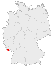
English: Location of Saabruecken in Germany
Lëtzebuergesch: Lag vu Saarbrécken an Däitschland
Zusammenfassung[編輯]
Lage von Saarbrücken in Deutschland
協議[編輯]
This image was generated with OpenGeoDB. The information there is placed in the public domain, images generated from OpenGeoDB are derivative works without passing the threshold of creativity, they are therefore also public domain.
| This work is ineligible for copyright and therefore in the public domain because it consists entirely of information that is common property and contains no original authorship. |
檔案歷史
撳個日期/時間去睇響嗰個時間出現過嘅檔案。
| 日期/時間 | 縮圖 | 尺寸 | 用戶 | 註解 | |
|---|---|---|---|---|---|
| 現時 | 2006年6月25號 (日) 16:18 | | 188 × 235(5 KB) | Yassen~commonswiki(傾偈 | 貢獻) | english:Location of Saabrucken in Germany<br> deutsch:Lage von Saarbrücken in Deutschland<br> {{GFDL-OpenGeoDB}} Category:Locator_maps_of_cities_in_Germany |
你無得衾咗個檔案。
檔案用途
以下嘅1版用到呢個檔:
全域檔案使用情況
下面嘅維基都用緊呢個檔案:
- af.wikipedia.org嘅使用情況
- azb.wikipedia.org嘅使用情況
- de.wikipedia.org嘅使用情況
- de.wikinews.org嘅使用情況
- fa.wikipedia.org嘅使用情況
- fy.wikipedia.org嘅使用情況
- io.wikipedia.org嘅使用情況
- is.wikipedia.org嘅使用情況
- ja.wikipedia.org嘅使用情況
- la.wiktionary.org嘅使用情況
- lmo.wikipedia.org嘅使用情況
- pl.wikivoyage.org嘅使用情況
- pms.wikipedia.org嘅使用情況
- pnb.wikipedia.org嘅使用情況
- ps.wikipedia.org嘅使用情況
- sq.wikipedia.org嘅使用情況
- uk.wikipedia.org嘅使用情況
- zh-yue.wikipedia.org嘅使用情況