File:Kerala msi 2018234 lrg August 22 2018.jpg

Archivo original (3700 × 4687 píxeles; tamaño de archivo: 5,12 MB; tipo MIME: image/jpeg)
Leyendas
Leyendas
Resumen
[editar]| Descripción |
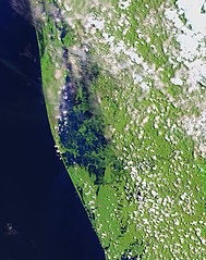
English: Residents in India’s state of Kerala are reeling from a "once-in-a-century" flood that displaced nearly a million people, caused hundreds of fatalities, and washed away homes. The region started receiving heavy rain on August 8, 2018, but news reports state that the flooding was worsened by releases from dams.
The Operational Land Imager (OLI) on the Landsat 8 satellite acquired the left image (bands 6-5-3) on February 6, 2018, before the flood. The Multispectral Instrument on the European Space Agency’s Sentinel-2 satellite acquired the right image (bands 11-8-3) on August 22, 2018, after flood water had inundated the area. The images are false-color, which makes flood water appear dark blue. Vegetation is bright green. Several rivers throughout the region spilled over their banks. Water from the Karuvannur River ran through 40 villages, and washed away a 2.2 kilometer (1.4 mile) stretch of land connecting two national highways. Elevated water levels along the Periyar River displaced thousands of people. NASA Earth Observatory images by Lauren Dauphin, using modified Copernicus Sentinel data (2018) processed by the European Space Agency and Landsat data from the U.S. Geological Survey. |
| Fecha | |
| Fuente | https://earthobservatory.nasa.gov/images/92669/before-and-after-the-kerala-floods, [File https://eoimages.gsfc.nasa.gov/images/imagerecords/92000/92669/kerala_msi_2018234_lrg.jpg] |
| Autor | NASA Earth Observatory images by Lauren Dauphin, using modified Copernicus Sentinel data (2018) processed by the European Space Agency and Landsat data from the U.S. Geological Survey |
| Otras versiones |
|

Licencia
[editar]
| Este archivo es de dominio público porque fue creado por la NASA. Las políticas sobre copyright de la NASA estipulan que «el material de la NASA no está protegido con copyright a menos que se indique lo contrario». (Políticas sobre copyright de la NASA o Políticas sobre la utilización de imágenes del Jet Propulsion Laboratory). | ||
 |
Advertencias:
|
Historial del archivo
Haz clic sobre una fecha y hora para ver el archivo tal como apareció en ese momento.
| Fecha y hora | Miniatura | Dimensiones | Usuario | Comentario | |
|---|---|---|---|---|---|
| actual | 07:06 28 ago 2018 | | 3700 × 4687 (5,12 MB) | Jkadavoor (discusión | contribs.) | {{Information |Description=Residents in India’s state of Kerala are reeling from a "once-in-a-century" flood that displaced nearly a million people, caused hundreds of fatalities, and washed away homes. The region started receiving heavy rain on August 8, 2018, but news reports state that the flooding was worsened by releases from dams. The Operational Land Imager (OLI) on the Landsat 8 satellite acquired the left image (bands 6-5-3) on February 6, 2018, before the flood. The Multispectral I... |
No puedes sobrescribir este archivo.
Usos del archivo
Las siguientes páginas usan este archivo:
Uso global del archivo
Las wikis siguientes utilizan este archivo:
- Uso en es.wikipedia.org
- Uso en ml.wikipedia.org
- Uso en or.wikipedia.org