File:Khangchendzonga np.jpg
跳至導覽
跳至搜尋

預覽大小:476 × 599 像素。 其他解析度:191 × 240 像素 | 381 × 480 像素 | 610 × 768 像素 | 813 × 1,024 像素 | 1,627 × 2,048 像素 | 5,213 × 6,562 像素。
原始檔案 (5,213 × 6,562 像素,檔案大小:2.92 MB,MIME 類型:image/jpeg)
說明
說明
添加單行說明來描述出檔案所代表的內容
摘要
[編輯]
| 描述 |
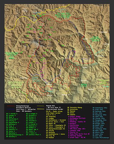
English: Contour generated by software from free SRTM data |
| 日期 |
2008年九月26日 2008年九月28日 (原始上傳日期) |
| 來源 | Transferred from en.wikipedia to Commons by Hike395 using CommonsHelper. |
| 作者 | ray (對話 · 貢獻) |
授權條款
[編輯]
ray,此作品的版權所有人,決定用以下授權條款發佈本作品:

|
已授權您依據自由軟體基金會發行的無固定段落、封面文字和封底文字GNU自由文件授權條款1.2版或任意後續版本,對本檔進行複製、傳播和/或修改。該協議的副本列在GNU自由文件授權條款中。 |
| 此檔案採用共享創意 姓名標示-相同方式分享 3.0 未在地化版本授權條款。 | ||
| 姓名標示: ray | ||
| ||
| 已新增授權條款標題至此檔案,作為GFDL授權更新的一部份。 |
原始上傳日誌
[編輯]
The original description page was here. All following user names refer to en.wikipedia.
- 2008-09-28 20:04 Pradiptaray 5213×6562× (3057157 bytes) {{Information |Description=I made the map. Contour generated by software from free SRTM data |Source=I created this work entirely by myself. |Date=26 Sep, 2008 |Author=[[User:Pradiptaray|ray]] ([[User talk:Pradiptaray|talk]]) |other_versions= }} ==Licens
- 2008-09-28 19:18 Pradiptaray 5213×6724× (3113277 bytes) {{Information |Description=I made the map. Contour generated by software from free SRTM data |Source=I created this work entirely by myself. |Date=26 Sep, 2008 |Author=~~~ |other_versions= }}
| 註解 | 該圖片含有註解:在維基媒體共享資源上查看註解 |
檔案歷史
點選日期/時間以檢視該時間的檔案版本。
| 日期/時間 | 縮圖 | 尺寸 | 用戶 | 備註 | |
|---|---|---|---|---|---|
| 目前 | 2012年6月14日 (四) 12:31 | | 5,213 × 6,562(2.92 MB) | Hike395(對話 | 貢獻) | {{Information |Description = {{en|Pradiptaray made the map. Contour generated by software from free SRTM data}} |Source =Pradiptaray at en.wikipedia |Date = {{date|2008|09|26}} — {{original upload... |
| 2012年6月14日 (四) 12:29 |  | 5,213 × 6,562(2.92 MB) | File Upload Bot (Magnus Manske)(對話 | 貢獻) | Transfered from en.wikipedia by User:Hike395 using CommonsHelper |
無法覆蓋此檔案。
檔案用途
下列頁面有用到此檔案:
全域檔案使用狀況
以下其他 wiki 使用了這個檔案:
- as.wikipedia.org 的使用狀況
- be.wikipedia.org 的使用狀況
- bn.wikipedia.org 的使用狀況
- en.wikipedia.org 的使用狀況
- es.wikipedia.org 的使用狀況
- fa.wikipedia.org 的使用狀況
- hi.wikipedia.org 的使用狀況
- ja.wikipedia.org 的使用狀況
- kn.wikipedia.org 的使用狀況
- mk.wikipedia.org 的使用狀況
- nn.wikipedia.org 的使用狀況
- ro.wikipedia.org 的使用狀況
- sl.wikipedia.org 的使用狀況
- ur.wikipedia.org 的使用狀況
- zh.wikipedia.org 的使用狀況
詮釋資料
分類:
- Maps of Sikkim
- Geography of Mangan district
- Maps of Kangchenjunga
- Maps of Tibet Autonomous Region
- Maps of Nepal
- Lonak Glacier
- Talung Glacier
- Rathong Glacier
- Yalung Glacier
- Yamatari Glacier
- Jannu Glacier
- Kangchenjunga Glacier
- Zemu Glacier
- Jongsang Ri
- Langpo Peak
- Pathibhara
- Kirat Chuli
- Nepal Peak
- Gimmigela Chuli
- Talung
- Rathong