File:Khazarfall1.png
Khazarfall1.png (670 × 448 პიქსელი, ფაილის ზომა: 32 კბ, MIME ტიპი: image/png)
Captions
Captions
By the year of 996 Poland extended to Oder river in the north-west and well in to Bautzen (Budziszyn) in the south also included Silesia (Slask)and part of Moravia. It is observed that Gernman Wikipedia "watchers" constantly place their borders way east as to create false claims to the historic lechitic territory as their own. Please correct this falsely created map to the correct shape.
რეზიუმე[რედაქტირება]
| აღწერა |
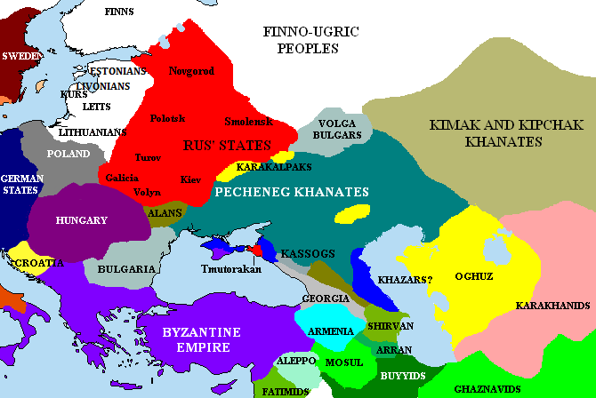
English: The Pontic steppes, c. 1015 (areas in blue possibly still under Khazar control). |
| თარიღი | |
| წყარო | Unknown (http://en.wikipedia.org/wiki/Image:Khazarfall1.png) |
| ავტორი | უცნობი |

|
Please translate the English parts of this template into Georgian.
არსებობს ამ გამოსახულების ვექტორული ანალოგი ("SVG"). გთხოვთ გამოიყენოთ იგი, რადგანაც მისი ხარისხი გაცილებით მაღალია. File:Khazarfall1.png → File:Khazarfall1.svg
ვექტორულ გრაფიკაზე ინფორმაციის მისაღებად, გთხოვთ იხილოთ ფაილების SVG ფორმატში გადაყვანის ინსტრუქცია. ასევე არსებობს ტექნიკური ინფორმაცია ფორმატ SVG-ის მხარდაჭერის შესახებ MediaWiki-ში. |
 |
ლიცენზია[რედაქტირება]
|
NOTE: "subject to disclaimers" below may not actually apply, this was tagged with {{GFDL-user-en}}, and after May 2007, en:Template:GFDL-self did not require disclaimers. Please check the image description page on the English Wikipedia (or, if it has been deleted, ask an English Wikipedia administrator). See Wikipedia:GFDL standardization for details. | ||||||||
Briangotts from en.wikipedia.org, ამ ნამუშევარზე საავტორო უფლებების მფლობელი, ვაქვეყნებ მას შემდეგი ლიცენზიით:
| ||||||||
|
Note: This tag should not be used. For images that were released on the English Wikipedia using either GFDL or GFDL-self with disclaimers, use {{GFDL-user-en-with-disclaimers}}. For images without disclaimers please use {{GFDL-user-en-no-disclaimers}} instead. If you are the copyright holder of files that were released on Wikipedia, please consider removing the disclaimers. |

ფაილის ისტორია
დააწკაპუნეთ თარიღზე/დროზე, რათა იხილოთ ფაილი, როგორც ის მაშინ გამოიყურებოდა.
| თარიღი/დრო | მინიატიურა | განზომილებები | მომხმარებელი | კომენტარი | |
|---|---|---|---|---|---|
| მიმდინარე | 00:15, 30 აპრილი 2023 | | 670 × 448 (32 კბ) | Андрей Романенко (განხილვა | წვლილი) | corrected (Rostov had been misplaced) |
| 19:51, 24 იანვარი 2021 |  | 670 × 448 (36 კბ) | Taron Saharyan (განხილვა | წვლილი) | Reverted to version as of 15:10, 27 May 2018 (UTC) | |
| 02:04, 2 სექტემბერი 2019 |  | 670 × 448 (33 კბ) | Georgiano (განხილვა | წვლილი) | Reverted to version as of 12:54, 22 March 2017 (UTC) | |
| 15:10, 27 მაისი 2018 |  | 670 × 448 (36 კბ) | Taron Saharyan (განხილვა | წვლილი) | все армянские города, в том числе столица Ани, оказались в Грузии | |
| 12:54, 22 მარტი 2017 |  | 670 × 448 (33 კბ) | Georgiano (განხილვა | წვლილი) | Reverted to version as of 08:28, 2 December 2015 (UTC) | |
| 21:25, 6 იანვარი 2017 |  | 670 × 448 (36 კბ) | Calrugem (განხილვა | წვლილი) | fixed caucasus | |
| 08:28, 2 დეკემბერი 2015 |  | 670 × 448 (33 კბ) | Taron Saharyan (განხილვა | წვლილი) | Reverted to version as of 10:12, 1 November 2015 (UTC) | |
| 08:23, 2 დეკემბერი 2015 |  | 670 × 448 (44 კბ) | Taron Saharyan (განხილვა | წვლილი) | коррекция границ Армении при Гагике I | |
| 10:12, 1 ნოემბერი 2015 |  | 670 × 448 (33 კბ) | Skylight 555 (განხილვა | წვლილი) | . | |
| 10:02, 1 ნოემბერი 2015 |  | 1 000 × 671 (294 კბ) | Skylight 555 (განხილვა | წვლილი) | Карта территории Печенегов и прилегающих государств. |
თქვენ არ შეგიძლიათ ამ ფაილზე გადაწერა.
ფაილის გამოყენება
მომდევნო გვერდები იყენებენ ამ ფაილს:
ფაილის გლობალური გამოყენება
ეს ფაილი გამოიყენება შემდეგ ვიკებში:
- გამოყენება als.wikipedia.org-ში
- გამოყენება an.wikipedia.org-ში
- გამოყენება ar.wikipedia.org-ში
- გამოყენება azb.wikipedia.org-ში
- გამოყენება bg.wikipedia.org-ში
- გამოყენება bn.wikipedia.org-ში
- გამოყენება cs.wikipedia.org-ში
- გამოყენება da.wikipedia.org-ში
- გამოყენება de.wikipedia.org-ში
- გამოყენება el.wikipedia.org-ში
- გამოყენება en.wikipedia.org-ში
- Khazars
- High Middle Ages
- Pechenegs
- Crimean Khanate
- Georgius Tzul
- Turkic migration
- User:Briangotts/maps
- Talk:Kievan Rus'/Kievan Rus' v Rus
- User:Kazkaskazkasako/Books/History
- Wikipedia talk:WikiProject Ukraine/Archive 4
- User:Chickstarr404/Gather lists/18093 – "The Spring of the Ram"
- History of the western steppe
- History of the central steppe
- User:WildFields/sandbox
- გამოყენება eo.wikipedia.org-ში
- გამოყენება es.wikipedia.org-ში
- გამოყენება et.wikipedia.org-ში
- გამოყენება eu.wikipedia.org-ში
- გამოყენება fi.wikipedia.org-ში
- გამოყენება fr.wikipedia.org-ში
- გამოყენება he.wikipedia.org-ში
- გამოყენება hr.wikipedia.org-ში
- გამოყენება hu.wikipedia.org-ში
- გამოყენება id.wikipedia.org-ში
- გამოყენება incubator.wikimedia.org-ში
- გამოყენება it.wikipedia.org-ში
იხილეთ, ამ ფაილის გლობალური გამოყენება.