File:Khazarfall1.png
Khazarfall1.png (670 × 448像素,文件大小:32 KB,MIME类型:image/png)
说明
说明
By the year of 996 Poland extended to Oder river in the north-west and well in to Bautzen (Budziszyn) in the south also included Silesia (Slask)and part of Moravia. It is observed that Gernman Wikipedia "watchers" constantly place their borders way east as to create false claims to the historic lechitic territory as their own. Please correct this falsely created map to the correct shape.
摘要[编辑]
| 描述 |
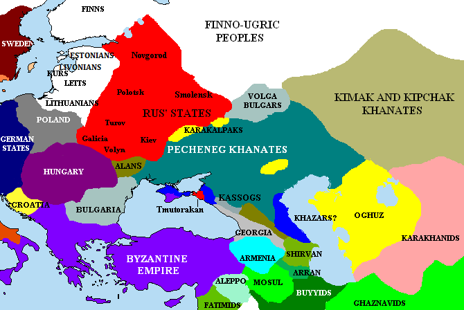
English: The Pontic steppes, c. 1015 (areas in blue possibly still under Khazar control). |
| 日期 | |
| 来源 | Unknown (http://en.wikipedia.org/wiki/Image:Khazarfall1.png) |
| 作者 | 未知 |

|
File:Khazarfall1.svg是此文件的矢量版本。 如果此文件质量不低于原点阵图,就应该将这个PNG格式文件替换为此文件。
File:Khazarfall1.png → File:Khazarfall1.svg
更多信息请参阅Help:SVG/zh。 |
 |
许可协议[编辑]
|
NOTE: "subject to disclaimers" below may not actually apply, this was tagged with {{GFDL-user-en}}, and after May 2007, en:Template:GFDL-self did not require disclaimers. Please check the image description page on the English Wikipedia (or, if it has been deleted, ask an English Wikipedia administrator). See Wikipedia:GFDL standardization for details. | ||||||||
Briangotts 位于英语维基百科,本作品著作权人,特此采用以下许可协议发表本作品:
| ||||||||
|
Note: This tag should not be used. For images that were released on the English Wikipedia using either GFDL or GFDL-self with disclaimers, use {{GFDL-user-en-with-disclaimers}}. For images without disclaimers please use {{GFDL-user-en-no-disclaimers}} instead. If you are the copyright holder of files that were released on Wikipedia, please consider removing the disclaimers. |

文件历史
点击某个日期/时间查看对应时刻的文件。
| 日期/时间 | 缩略图 | 大小 | 用户 | 备注 | |
|---|---|---|---|---|---|
| 当前 | 2023年4月30日 (日) 00:15 | | 670 × 448(32 KB) | Андрей Романенко(留言 | 贡献) | corrected (Rostov had been misplaced) |
| 2021年1月24日 (日) 19:51 |  | 670 × 448(36 KB) | Taron Saharyan(留言 | 贡献) | Reverted to version as of 15:10, 27 May 2018 (UTC) | |
| 2019年9月2日 (一) 02:04 |  | 670 × 448(33 KB) | Georgiano(留言 | 贡献) | Reverted to version as of 12:54, 22 March 2017 (UTC) | |
| 2018年5月27日 (日) 15:10 |  | 670 × 448(36 KB) | Taron Saharyan(留言 | 贡献) | все армянские города, в том числе столица Ани, оказались в Грузии | |
| 2017年3月22日 (三) 12:54 |  | 670 × 448(33 KB) | Georgiano(留言 | 贡献) | Reverted to version as of 08:28, 2 December 2015 (UTC) | |
| 2017年1月6日 (五) 21:25 |  | 670 × 448(36 KB) | Calrugem(留言 | 贡献) | fixed caucasus | |
| 2015年12月2日 (三) 08:28 |  | 670 × 448(33 KB) | Taron Saharyan(留言 | 贡献) | Reverted to version as of 10:12, 1 November 2015 (UTC) | |
| 2015年12月2日 (三) 08:23 |  | 670 × 448(44 KB) | Taron Saharyan(留言 | 贡献) | коррекция границ Армении при Гагике I | |
| 2015年11月1日 (日) 10:12 |  | 670 × 448(33 KB) | Skylight 555(留言 | 贡献) | . | |
| 2015年11月1日 (日) 10:02 |  | 1,000 × 671(294 KB) | Skylight 555(留言 | 贡献) | Карта территории Печенегов и прилегающих государств. |
您不可以覆盖此文件。
文件用途
以下4个页面使用本文件:
全域文件用途
以下其他wiki使用此文件:
- als.wikipedia.org上的用途
- an.wikipedia.org上的用途
- ar.wikipedia.org上的用途
- azb.wikipedia.org上的用途
- bg.wikipedia.org上的用途
- bn.wikipedia.org上的用途
- cs.wikipedia.org上的用途
- da.wikipedia.org上的用途
- de.wikipedia.org上的用途
- el.wikipedia.org上的用途
- en.wikipedia.org上的用途
- Khazars
- High Middle Ages
- Pechenegs
- Crimean Khanate
- Georgius Tzul
- Turkic migration
- User:Briangotts/maps
- Talk:Kievan Rus'/Kievan Rus' v Rus
- User:Kazkaskazkasako/Books/History
- Wikipedia talk:WikiProject Ukraine/Archive 4
- User:Chickstarr404/Gather lists/18093 – "The Spring of the Ram"
- History of the western steppe
- History of the central steppe
- User:WildFields/sandbox
- eo.wikipedia.org上的用途
- es.wikipedia.org上的用途
- et.wikipedia.org上的用途
- eu.wikipedia.org上的用途
- fi.wikipedia.org上的用途
- fr.wikipedia.org上的用途
- he.wikipedia.org上的用途
- hr.wikipedia.org上的用途
- hu.wikipedia.org上的用途
- id.wikipedia.org上的用途
- incubator.wikimedia.org上的用途
- it.wikipedia.org上的用途
查看本文件的更多全域用途。