File:Khotan River.png
跳转到导航
跳转到搜索
没有更高的分辨率。
Khotan_River.png (340 × 300像素,文件大小:63 KB,MIME类型:image/png)
说明
说明
添加一行文字以描述该文件所表现的内容
摘要
[编辑]
| 描述 |
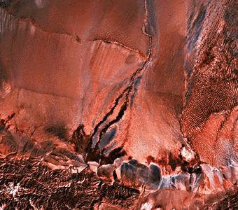
English: Image of the Khotan River taken from space. |
| 日期 | 2006年2月27日 (原始上传日期) |
| 来源 | The Southwest Taklimakan Desert from NASA's Geomorphology from Space |
| 作者 | NASA folks |
许可协议
[编辑]
| 本文件完全由NASA创作,在美国属于公有领域。根据NASA的版权方针,NASA的材料除非另有声明否则不受版权保护。(参见Template:PD-USGov/zh、NASA版权方针页面或JPL图片使用方针。) | ||
 |
警告:
|
原始上传日志
[编辑]
原始描述頁面位於這裡。下列使用者名稱均來自en.wikipedia。
- 2006-02-27 04:33 Kaldari 340×300× (64907 bytes) Image of the Khotan River taken from space. Source: [[http://daac.gsfc.nasa.gov/geomorphology/GEO_8/GEO_PLATE_E-27.HTML The Southwest Taklimakan Desert] from NASA's [http://daac.gsfc.nasa.gov/geomorphology/GEO_COMPLETE_TOC.shtml Geomorphology from Space].
文件历史
点击某个日期/时间查看对应时刻的文件。
| 日期/时间 | 缩略图 | 大小 | 用户 | 备注 | |
|---|---|---|---|---|---|
| 当前 | 2010年1月24日 (日) 21:06 | | 340 × 300(63 KB) | File Upload Bot (Magnus Manske)(留言 | 贡献) | {{BotMoveToCommons|en.wikipedia|year={{subst:CURRENTYEAR}}|month={{subst:CURRENTMONTHNAME}}|day={{subst:CURRENTDAY}}}} {{Information |Description={{en|Image of the en:Khotan River taken from space. Source: [http://daac.gsfc.nasa.gov/geomorphology/G |
您不可以覆盖此文件。
文件用途
以下页面使用本文件:
全域文件用途
以下其他wiki使用此文件:
- arz.wikipedia.org上的用途
- azb.wikipedia.org上的用途
- be.wikipedia.org上的用途
- bg.wikipedia.org上的用途
- ca.wikipedia.org上的用途
- ceb.wikipedia.org上的用途
- cv.wikipedia.org上的用途
- de.wikipedia.org上的用途
- en.wikipedia.org上的用途
- es.wikipedia.org上的用途
- fr.wikipedia.org上的用途
- he.wikipedia.org上的用途
- he.wikivoyage.org上的用途
- hi.wikipedia.org上的用途
- hu.wikipedia.org上的用途
- it.wikipedia.org上的用途
- ja.wikipedia.org上的用途
- ka.wikipedia.org上的用途
- pl.wikipedia.org上的用途
- ru.wikipedia.org上的用途
- sk.wikipedia.org上的用途
- sv.wikipedia.org上的用途
- ug.wikipedia.org上的用途
- uk.wikipedia.org上的用途
- www.wikidata.org上的用途
- zh.wikipedia.org上的用途