File:King John's campaign 1215-6.png
Aller à la navigation
Aller à la recherche
Taille de cet aperçu : 458 × 600 pixels. Autres résolutions : 183 × 240 pixels | 366 × 480 pixels | 781 × 1 023 pixels.
Fichier d’origine (781 × 1 023 pixels, taille du fichier : 165 kio, type MIME : image/png)
Légendes
Légendes
Ajoutez en une ligne la description de ce que représente ce fichier
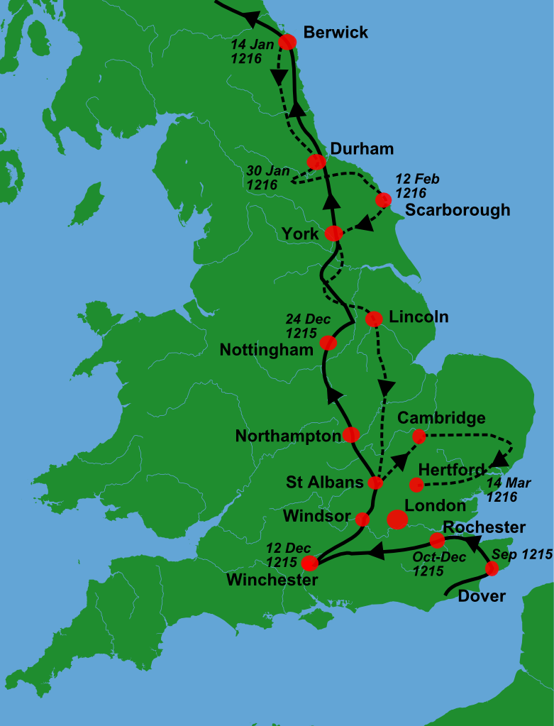
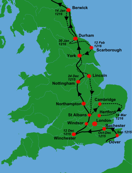
| Description | A blank locator map for Great Britain, with King John's 1216-6 military campaigns superimposed on it (using information from Warren, "King John", p. 250. The idea is to superimpose Image:dot4gb.svg at the appropriate point. See w:Template:GBthumb for code to do this. These two images can replace any locator map posted by Lupin - see w:Special:Contributions/LupinBot. This is a vectorized version of Image:Gb4dot.png, with the scale changed from 200 km to 150 km/150 miles. The shoreline data come from the file gshhs_h.b from the GSHHS, and the rivers and the Irish border come from the CIA World DataBank II; both sources are in the public domain. Mercator projection. == |
| Date | (UTC) |
| Source |
Travail personnel avec:
|
| Auteur |
|
| Cette image a été retouchée, ce qui signifie qu'elle a été modifiée par ordinateur et est différente de l'image d'origine. Liste des modifications : Trimmed, campaign superimposed. L'image d'origine se trouve ici : Gb4dot.svg:
|
Moi, en tant que détenteur des droits d’auteur sur cette œuvre, je la publie sous la licence suivante :
| Moi, propriétaire des droits d’auteur sur cette œuvre, la place dans le domaine public. Ceci s'applique dans le monde entier. Dans certains pays, ceci peut ne pas être possible ; dans ce cas : J’accorde à toute personne le droit d’utiliser cette œuvre dans n’importe quel but, sans aucune condition, sauf celles requises par la loi. |
Journal des téléversements d’origine
[modifier]
This image is a derivative work of the following images:
- File:Gb4dot.svg licensed with PD-self
Téléversé avec derivativeFX
Historique du fichier
Cliquer sur une date et heure pour voir le fichier tel qu'il était à ce moment-là.
| Date et heure | Vignette | Dimensions | Utilisateur | Commentaire | |
|---|---|---|---|---|---|
| actuel | 2 janvier 2011 à 10:08 | | 781 × 1 023 (165 kio) | Hchc2009 (d | contributions) | {{Information |Description=A blank locator map for Great Britain, with King John's 1216-6 military campaigns superimposed on it (using information from Warren, "King John", p.250. The idea is to superimpose Image:dot4gb.svg at the appropriate point. |
Vous ne pouvez pas remplacer ce fichier.
Utilisations locales du fichier
Aucune page n’utilise ce fichier.
Utilisations du fichier sur d’autres wikis
Les autres wikis suivants utilisent ce fichier :
- Utilisation sur az.wikipedia.org
- Utilisation sur en.wikipedia.org
- Utilisation sur fr.wikipedia.org
- Utilisation sur gl.wikipedia.org
- Utilisation sur hu.wikipedia.org
- Utilisation sur nl.wikipedia.org
- Utilisation sur ru.wikipedia.org
- Utilisation sur tr.wikipedia.org
- Utilisation sur zh.wikipedia.org