File:King Site Aerial HRoe 2018.jpg
跳至導覽
跳至搜尋
無更高解析度可提供。
King_Site_Aerial_HRoe_2018.jpg (380 × 253 像素,檔案大小:117 KB,MIME 類型:image/jpeg)
說明
說明
添加單行說明來描述出檔案所代表的內容
摘要
[編輯]
| 描述 |
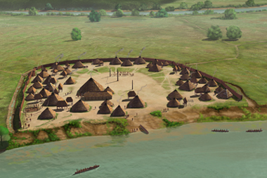
English: The King Site (9FL5) is a proto-Mvskoke (Muscogee or Creek confederacy) Barnett Phase Mississippian culture village occupied in the late protohistoric period during a roughly 30-40 year period sometime between the 1540 de Soto entrada and 1600 CE. It is located on a meander bend of the Coosa River in northwestern Georgia and was one of 5 non-mound subsidiary settlements of the"Rome Polity"which was centered on the nearby Nixon mound site (9FL162). The 2.3 hectare village featured a 1300-foot long ditch and palisade, an open plaza with one large post in the center and a 48-foot square ceremonial structure in its northeastern edge, and 40-50 houses surrounding the plaza. Digital illustration, all rights held by the artist, Herb Roe © 2018. |
| 日期 | |
| 來源 | 自己的作品 |
| 作者 | Herb Roe |
| 拍攝地點 | | 位於此地的本圖片與其他圖片: OpenStreetMap |
|---|
授權條款
[編輯]
此檔案採用共享創意 姓名標示-相同方式分享 4.0 國際授權條款。
姓名標示: Herb Roe
- 您可以自由:
- 分享 – 複製、發佈和傳播本作品
- 重新修改 – 創作演繹作品
- 惟需遵照下列條件:
- 姓名標示 – 您必須指名出正確的製作者,和提供授權條款的連結,以及表示是否有對內容上做出變更。您可以用任何合理的方式來行動,但不得以任何方式表明授權條款是對您許可或是由您所使用。
- 相同方式分享 – 如果您利用本素材進行再混合、轉換或創作,您必須基於如同原先的相同或兼容的條款,來分布您的貢獻成品。
檔案歷史
點選日期/時間以檢視該時間的檔案版本。
| 日期/時間 | 縮圖 | 尺寸 | 用戶 | 備註 | |
|---|---|---|---|---|---|
| 目前 | 2018年11月13日 (二) 00:27 | | 380 × 253(117 KB) | Heironymous Rowe(對話 | 貢獻) | User created page with UploadWizard |
無法覆蓋此檔案。
檔案用途
下列頁面有用到此檔案:
全域檔案使用狀況
以下其他 wiki 使用了這個檔案:
- en.wikipedia.org 的使用狀況
- es.wikipedia.org 的使用狀況
- sr.wikipedia.org 的使用狀況
- www.wikidata.org 的使用狀況
- zh.wikipedia.org 的使用狀況
詮釋資料
分類:
- Mississippian sites
- Herb Roe
- Archaeological sites in Georgia (U.S. state)
- Pre-Columbian architecture in Georgia (U.S. state)
- Maps of the history of Georgia (U.S. state)
- Pre-Columbian fortifications in the United States
- Plans of fortifications in the United States
- Muscogee
- Coosa River
- History of Floyd County, Georgia
- Pre-Columbian cities in the United States
- Coosa chiefdom
- Georgia (U.S. state) in the 16th century