File:King Site Aerial HRoe 2018.jpg
跳转到导航
跳转到搜索
没有更高的分辨率。
King_Site_Aerial_HRoe_2018.jpg (380 × 253像素,文件大小:117 KB,MIME类型:image/jpeg)
说明
说明
添加一行文字以描述该文件所表现的内容
摘要
[编辑]
| 描述 |
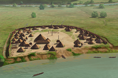
English: The King Site (9FL5) is a proto-Mvskoke (Muscogee or Creek confederacy) Barnett Phase Mississippian culture village occupied in the late protohistoric period during a roughly 30-40 year period sometime between the 1540 de Soto entrada and 1600 CE. It is located on a meander bend of the Coosa River in northwestern Georgia and was one of 5 non-mound subsidiary settlements of the"Rome Polity"which was centered on the nearby Nixon mound site (9FL162). The 2.3 hectare village featured a 1300-foot long ditch and palisade, an open plaza with one large post in the center and a 48-foot square ceremonial structure in its northeastern edge, and 40-50 houses surrounding the plaza. Digital illustration, all rights held by the artist, Herb Roe © 2018. |
| 日期 | |
| 来源 | 自己的作品 |
| 作者 | Herb Roe |
| 相机位置 | | 在以下服务上查看本图像和附近其他图像: OpenStreetMap |
|---|
许可协议
[编辑]
本文件采用知识共享署名-相同方式共享 4.0 国际许可协议授权。
署名: Herb Roe
- 您可以自由地:
- 共享 – 复制、发行并传播本作品
- 修改 – 改编作品
- 惟须遵守下列条件:
- 署名 – 您必须对作品进行署名,提供授权条款的链接,并说明是否对原始内容进行了更改。您可以用任何合理的方式来署名,但不得以任何方式表明许可人认可您或您的使用。
- 相同方式共享 – 如果您再混合、转换或者基于本作品进行创作,您必须以与原先许可协议相同或相兼容的许可协议分发您贡献的作品。
文件历史
点击某个日期/时间查看对应时刻的文件。
| 日期/时间 | 缩略图 | 大小 | 用户 | 备注 | |
|---|---|---|---|---|---|
| 当前 | 2018年11月13日 (二) 00:27 | | 380 × 253(117 KB) | Heironymous Rowe(留言 | 贡献) | User created page with UploadWizard |
您不可以覆盖此文件。
文件用途
以下页面使用本文件:
全域文件用途
以下其他wiki使用此文件:
- en.wikipedia.org上的用途
- es.wikipedia.org上的用途
- sr.wikipedia.org上的用途
- www.wikidata.org上的用途
- zh.wikipedia.org上的用途
元数据
分类:
- Mississippian sites
- Herb Roe
- Archaeological sites in Georgia (U.S. state)
- Pre-Columbian architecture in Georgia (U.S. state)
- Maps of the history of Georgia (U.S. state)
- Pre-Columbian fortifications in the United States
- Plans of fortifications in the United States
- Muscogee
- Coosa River
- History of Floyd County, Georgia
- Pre-Columbian cities in the United States
- Coosa chiefdom
- Georgia (U.S. state) in the 16th century