File:Kingdom of Germany 1004.svg
Siirry navigaatioon
Siirry hakuun

Tämän PNG-esikatselun koko koskien SVG-tiedostoa: 485 × 340 kuvapistettä. Muut resoluutiot: 320 × 224 kuvapistettä | 640 × 449 kuvapistettä | 1 024 × 718 kuvapistettä | 1 280 × 897 kuvapistettä | 2 560 × 1 795 kuvapistettä.
Alkuperäinen tiedosto (SVG-tiedosto; oletustarkkuus 485 × 340 kuvapistettä; tiedostokoko 1,23 MiB)
Kuvatekstit
Kuvatekstit
Lisää yhden rivin pituinen kuvaus tästä tiedostosta
Yhteenveto
[muokkaa]Tämä vektorigrafiikkatiedosto luotiin käyttäen apuna ohjelmaa Inkscape .


.svg)
.svg)
.svg)
.svg)
.svg)


.svg)
.svg)
.svg)


.png)
.png)


.svg)


.svg)

.svg)


.svg)
.svg)
.svg)
.svg)


.svg)
.png)


.svg)


.svg)
.svg)


.svg)


.svg)


.svg)
.svg)
.svg)
.svg)
.svg)
.svg)
.svg)
.svg)
_cropped.svg)
.svg)
.svg)
.svg)
.svg)
.svg)
.svg)
.svg)
.svg)
.svg)
.svg)
.svg)
.svg)
.svg)
.svg)
.svg)
.svg)
.svg)
.svg)
.svg)
.svg)
.svg)
.svg)
.svg)
.svg)
.svg)
.svg)
.svg)
.svg)
.svg)
.svg)
.svg)
.svg)
.svg)
.svg)
.svg)
.svg)
.svg)
.svg)
.svg)
.svg)
.svg)
.svg)
.svg)
.svg)
.svg)
Lisenssi
[muokkaa]
Tämä tiedosto on lisensoitu Creative Commons Nimeä-JaaSamoin 4.0 Kansainvälinen -lisenssillä.
- Voit:
- jakaa – kopioida, levittää ja esittää teosta
- remiksata – valmistaa muutettuja teoksia
- Seuraavilla ehdoilla:
- nimeäminen – Sinun on mainittava lähde asianmukaisesti, tarjottava linkki lisenssiin sekä merkittävä, mikäli olet tehnyt muutoksia. Voit tehdä yllä olevan millä tahansa kohtuullisella tavalla, mutta et siten, että annat ymmärtää lisenssinantajan suosittelevan sinua tai teoksen käyttöäsi.
- jaa samoin – Jos muutat tai perustat tähän työhön, voit jakaa tuloksena syntyvää työtä vain tällä tai tämän kaltaisella lisenssillä.
Tiedoston historia
Päiväystä napsauttamalla näet, millainen tiedosto oli kyseisellä hetkellä.
| Päiväys | Pienoiskuva | Koko | Käyttäjä | Kommentti | |
|---|---|---|---|---|---|
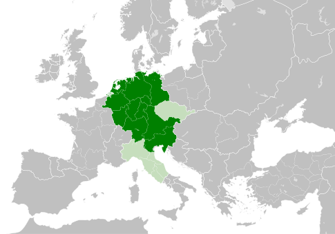
| nykyinen | 4. toukokuuta 2021 kello 11.49 | | 485 × 340 (1,23 MiB) | E-960 (keskustelu | muokkaukset) | Tribute was paid under Mieszko I, by the year 1000 Bolesław I the Brave stopped paying it |
| 23. toukokuuta 2016 kello 13.14 |  | 485 × 340 (1,23 MiB) | Der Golem (keskustelu | muokkaukset) | Duchy of Bohemia was part of the Holy Roman Empire, but not within the Kingdom of Germany | |
| 22. toukokuuta 2016 kello 20.19 |  | 485 × 340 (1,23 MiB) | Alphathon (keskustelu | muokkaukset) | == {{int:filedesc}} == {{Inkscape}} {{Information |Description={{en|A map of the Kingdom of Germany within the Holy Roman Empire and within Europe circa 1004 CE, after the incorporation of the [[:en:Duchy of Bohemia|Duchy of... |
Et voi tallentaa uutta tiedostoa tämän tilalle.
Tiedoston käyttö
Seuraava sivu käyttää tätä tiedostoa:
Tiedoston järjestelmänlaajuinen käyttö
Seuraavat muut wikit käyttävät tätä tiedostoa:
- Käyttö kohteessa az.wikipedia.org
- Käyttö kohteessa ba.wikipedia.org
- Käyttö kohteessa be.wikipedia.org
- Käyttö kohteessa ca.wikipedia.org
- Käyttö kohteessa cs.wikipedia.org
- Käyttö kohteessa en.wikipedia.org
- Käyttö kohteessa eo.wikipedia.org
- Käyttö kohteessa es.wikipedia.org
- Käyttö kohteessa et.wikipedia.org
- Käyttö kohteessa eu.wikipedia.org
- Käyttö kohteessa fr.wikipedia.org
- Käyttö kohteessa id.wikipedia.org
- Käyttö kohteessa ja.wikipedia.org
- Käyttö kohteessa ko.wikipedia.org
- Käyttö kohteessa la.wikipedia.org
- Käyttö kohteessa lv.wikipedia.org
- Käyttö kohteessa pl.wikipedia.org
- Käyttö kohteessa ru.wikipedia.org
- Käyttö kohteessa uk.wikipedia.org
- Käyttö kohteessa www.wikidata.org
.svg)