File:Kingdom of Hungary counties.svg
Salta a la navegació
Salta a la cerca

Mida d'aquesta previsualització PNG del fitxer SVG: 779 × 513 píxels. Altres resolucions: 320 × 211 píxels | 640 × 421 píxels | 1.024 × 674 píxels | 1.280 × 843 píxels | 2.560 × 1.686 píxels.
Fitxer original (fitxer SVG, nominalment 779 × 513 píxels, mida del fitxer: 235 Ko)
Llegendes
Llegendes
Afegeix una explicació d'una línia del que representa aquest fitxer
Resum
[modifica]
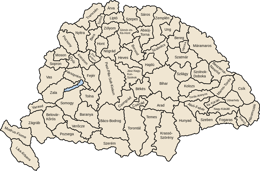
| Descripció | Map of counties of Kingdom of Hungary (Hungary proper and Croatia & Slavonia), 1886-1918 |
| Data | |
| Font | Treball propi |
| Autor | User:IMeowbot |
| Altres versions | Derivative works of this file: Kingdom of Hungary counties-2.svg |
| SVG development | W3C-validity not checked. |
Llicència
[modifica]
| Jo, el titular del copyright d'aquesta obra, l'allibero al domini públic. Això s'aplica a tot el món. En alguns països això pot no ser legalment possible, en tal cas: Jo faig concessió a tothom del dret d'usar aquesta obra per a qualsevol propòsit, sense cap condició llevat d'aquelles requerides per la llei. |
Historial del fitxer
Cliqueu una data/hora per veure el fitxer tal com era aleshores.
| Data/hora | Miniatura | Dimensions | Usuari/a | Comentari | |
|---|---|---|---|---|---|
| actual | 07:41, 19 jul 2023 | | 779 × 513 (235 Ko) | Alphathon (discussió | contribucions) | Reverted to version as of 22:47, 16 August 2022 (UTC). Bars/Hont and Csongrád/Bács-Bodrog borders are inaccurate, several more are distored (most only slightly) and the file is a "FakeSVG" – a raster image using an SVG as a container with no actual vector elements. |
| 22:43, 20 gen 2023 |  | 8.277 × 5.472 (589 Ko) | Ascended Dreamer (discussió | contribucions) | Added FIume and increased line weight | |
| 22:31, 20 gen 2023 |  | 8.277 × 5.472 (607 Ko) | Ascended Dreamer (discussió | contribucions) | Increased border accuracy | |
| 22:47, 16 ago 2022 |  | 779 × 513 (235 Ko) | Alphathon (discussió | contribucions) | corrected õ → ő (tilde → double accute) | |
| 17:53, 5 des 2009 |  | 779 × 513 (235 Ko) | SimonTrew (discussió | contribucions) | Fix spelling error Veszprém. | |
| 14:24, 3 des 2009 |  | 779 × 513 (235 Ko) | SimonTrew (discussió | contribucions) | Fixed spelling of "Poszsony" -> "Pozsony". | |
| 20:25, 20 ago 2007 |  | 779 × 513 (235 Ko) | Xavax (discussió | contribucions) | == Summary == {{Information| |Description= Map of counties of Hungary with Croatia & Slavonia, 1886-1918 |Source=own drawing |Date=April 30, 2006 |Author=User:IMeowbot |Permission= |other_versions= }} == Licensing == {{PD-self}} <!--Categories--> [[ | |
| 22:10, 30 abr 2006 |  | 779 × 513 (223 Ko) | IMeowbot~commonswiki (discussió | contribucions) | line weight | |
| 21:34, 30 abr 2006 |  | 779 × 513 (221 Ko) | IMeowbot~commonswiki (discussió | contribucions) | ||
| 18:34, 30 abr 2006 |  | 779 × 513 (195 Ko) | IMeowbot~commonswiki (discussió | contribucions) | {{Information| |Description= Map of late 1870s Hungary counties |Source=own drawing |Date=April 30, 2006 |Author=User:IMeowbot |Permission= |other_versions= }} |
No podeu sobreescriure aquest fitxer.
Ús del fitxer
Les 40 pàgines següents utilitzen aquest fitxer:
- Atlas of Croatia
- Atlas of Hungary
- Atlas of Slovakia
- Atlas of Székely Land
- Magyarország
- File:Historic counties of Hungary.png
- File:Kingdom of Hungary counties-2.svg
- File:Kingdom of Hungary counties (sk).svg
- File:Kingdom of Hungary counties (sk-Abovsko-turnianska).svg
- File:Kingdom of Hungary counties (sk-Aradská).svg
- File:Kingdom of Hungary counties (sk-Baraňská).svg
- File:Kingdom of Hungary counties (sk-Bihárska).svg
- File:Kingdom of Hungary counties (sk-Bjelovarsko-križevetská).svg
- File:Kingdom of Hungary counties (sk-Boršodská).svg
- File:Kingdom of Hungary counties (sk-Brašovská).svg
- File:Kingdom of Hungary counties (sk-Bystricko-nasodská).svg
- File:Kingdom of Hungary counties (sk-Báčsko-bodrodská).svg
- File:Kingdom of Hungary counties (sk-Dolnobelehradská).svg
- File:Kingdom of Hungary counties (sk-Fogarašská).svg
- File:Kingdom of Hungary counties (sk-Gemersko-malohontská).svg
- File:Kingdom of Hungary counties (sk-Hajducká).svg
- File:Kingdom of Hungary counties (sk-Hevešská).svg
- File:Kingdom of Hungary counties (sk-Hontianska).svg
- File:Kingdom of Hungary counties (sk-Huňadská).svg
- File:Kingdom of Hungary counties (sk-Háromsecká).svg
- File:Kingdom of Hungary counties (sk-Jasovsko-veľkokumánsko-solnocká).svg
- File:Kingdom of Hungary counties (sk-Klužská).svg
- File:Kingdom of Hungary counties (sk-Komárňanská).svg
- File:Kingdom of Hungary counties (sk-Krasovsko-severinská).svg
- File:Kingdom of Hungary counties (sk-Licko-krbavská).svg
- File:Kingdom of Hungary counties (sk-Liptovská).svg
- File:Kingdom of Hungary counties (sk-Malokykulská).svg
- File:Kingdom of Hungary counties (sk-Marmarošská).svg
- File:Kingdom of Hungary counties (sk-Marušsko-turdská).svg
- File:Kingdom of Hungary counties (sk-Modrušsko-skorjecká).svg
- File:Kingdom of Hungary counties (sk-Mošonská).svg
- File:Kingdom of Hungary counties (sk-Čanadská).svg
- File:Kingdom of Hungary counties (sk-Čická).svg
- File:Kingdom of Hungary counties (sk-Čongrádska).svg
- File:Kingdom of Hungary counties 1768x1168.png
.svg)
.svg)
.svg)
.svg)
.svg)
.svg)
.svg)
.svg)
.svg)
.svg)
.svg)
.svg)
.svg)
.svg)
.svg)
.svg)
.svg)
.svg)
.svg)
.svg)
.svg)
.svg)
.svg)
.svg)
.svg)
.svg)
.svg)
.svg)
.svg)
.svg)
.svg)
.svg)
Ús global del fitxer
Utilització d'aquest fitxer en altres wikis:
- Utilització a als.wikipedia.org
- Utilització a an.wikipedia.org
- Utilització a ar.wikipedia.org
- Utilització a azb.wikipedia.org
- Utilització a bg.wikipedia.org
- Utilització a bn.wikipedia.org
- Utilització a ca.wikipedia.org
- Utilització a cs.wikipedia.org
- Utilització a cy.wikipedia.org
- Utilització a de.wikipedia.org
- Utilització a el.wikipedia.org
- Utilització a en.wikipedia.org
- Liptó County
- Zemplén County
- Hont County
- Bars County
- Turóc County
- Brassó County
- Bihar County
- Kingdom of Hungary
- Esztergom County
- Pozsony County
- Nyitra County
- Moson County
- Sopron County
- Bács-Bodrog County
- Heves County (former)
- Jász-Nagykun-Szolnok County (former)
- Trencsén County
- Zólyom County
- Pest-Pilis-Solt-Kiskun County
- Komárom County
- Bereg County
- Borsod County
- Ung County
- Hajdú County
- Máramaros County
- Szabolcs County
- Szatmár County
Vegeu més usos globals d'aquest fitxer.