File:Kingdom of Hungary counties.svg
Pāriet uz navigāciju
Pāriet uz meklēšanu

Size of this PNG preview of this SVG file: 779 × 513 pikseļi. Citi izmēri: 320 × 211 pikseļi | 640 × 421 pikseļi | 1 024 × 674 pikseļi | 1 280 × 843 pikseļi | 2 560 × 1 686 pikseļi.
Sākotnējais fails (SVG fails, definētais izmērs 779 × 513 pikseļi, faila izmērs: 235 KB)
Captions
Captions
Pievieno vienas rindiņas aprakstu, ko šis fails attēlo
Kopsavilkums[labot šo sadaļu]
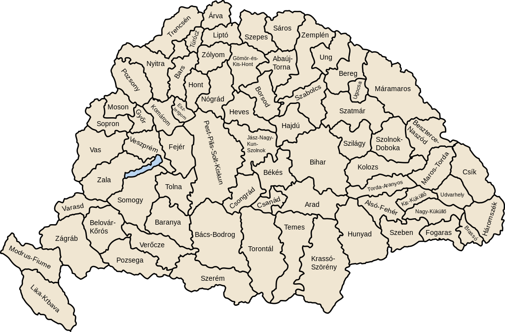
| Apraksts | Map of counties of Kingdom of Hungary (Hungary proper and Croatia & Slavonia), 1886-1918 |
| Datums | |
| Avots | Paša darbs |
| Autors | User:IMeowbot |
| Citas versijas | Derivative works of this file: Kingdom of Hungary counties-2.svg |
| SVG development | W3C-validity not checked. |
Licence[labot šo sadaļu]
| I, the copyright holder of this work, release this work into the public domain. This applies worldwide. In some countries this may not be legally possible; if so: I grant anyone the right to use this work for any purpose, without any conditions, unless such conditions are required by law. |
Faila hronoloģija
Uzklikšķini uz datums/laiks kolonnā esošās saites, lai apskatītos, kā šis fails izskatījās tad.
| Datums/Laiks | Attēls | Izmēri | Dalībnieks | Komentārs | |
|---|---|---|---|---|---|
| tagadējais | 2023. gada 19. jūlijs, plkst. 07.41 | | 779 × 513 (235 KB) | Alphathon (diskusija | devums) | Reverted to version as of 22:47, 16 August 2022 (UTC). Bars/Hont and Csongrád/Bács-Bodrog borders are inaccurate, several more are distored (most only slightly) and the file is a "FakeSVG" – a raster image using an SVG as a container with no actual vector elements. |
| 2023. gada 20. janvāris, plkst. 22.43 |  | 8 277 × 5 472 (589 KB) | Ascended Dreamer (diskusija | devums) | Added FIume and increased line weight | |
| 2023. gada 20. janvāris, plkst. 22.31 |  | 8 277 × 5 472 (607 KB) | Ascended Dreamer (diskusija | devums) | Increased border accuracy | |
| 2022. gada 16. augusts, plkst. 22.47 |  | 779 × 513 (235 KB) | Alphathon (diskusija | devums) | corrected õ → ő (tilde → double accute) | |
| 2009. gada 5. decembris, plkst. 17.53 |  | 779 × 513 (235 KB) | SimonTrew (diskusija | devums) | Fix spelling error Veszprém. | |
| 2009. gada 3. decembris, plkst. 14.24 |  | 779 × 513 (235 KB) | SimonTrew (diskusija | devums) | Fixed spelling of "Poszsony" -> "Pozsony". | |
| 2007. gada 20. augusts, plkst. 20.25 |  | 779 × 513 (235 KB) | Xavax (diskusija | devums) | == Summary == {{Information| |Description= Map of counties of Hungary with Croatia & Slavonia, 1886-1918 |Source=own drawing |Date=April 30, 2006 |Author=User:IMeowbot |Permission= |other_versions= }} == Licensing == {{PD-self}} <!--Categories--> [[ | |
| 2006. gada 30. aprīlis, plkst. 22.10 |  | 779 × 513 (223 KB) | IMeowbot~commonswiki (diskusija | devums) | line weight | |
| 2006. gada 30. aprīlis, plkst. 21.34 |  | 779 × 513 (221 KB) | IMeowbot~commonswiki (diskusija | devums) | ||
| 2006. gada 30. aprīlis, plkst. 18.34 |  | 779 × 513 (195 KB) | IMeowbot~commonswiki (diskusija | devums) | {{Information| |Description= Map of late 1870s Hungary counties |Source=own drawing |Date=April 30, 2006 |Author=User:IMeowbot |Permission= |other_versions= }} |
Šo failu nevar pārrakstīt.
Faila lietojums
Šo failu izmanto šajās 40 lapās:
- Atlas of Croatia
- Atlas of Hungary
- Atlas of Slovakia
- Atlas of Székely Land
- Magyarország
- File:Historic counties of Hungary.png
- File:Kingdom of Hungary counties-2.svg
- File:Kingdom of Hungary counties (sk).svg
- File:Kingdom of Hungary counties (sk-Abovsko-turnianska).svg
- File:Kingdom of Hungary counties (sk-Aradská).svg
- File:Kingdom of Hungary counties (sk-Baraňská).svg
- File:Kingdom of Hungary counties (sk-Bihárska).svg
- File:Kingdom of Hungary counties (sk-Bjelovarsko-križevetská).svg
- File:Kingdom of Hungary counties (sk-Boršodská).svg
- File:Kingdom of Hungary counties (sk-Brašovská).svg
- File:Kingdom of Hungary counties (sk-Bystricko-nasodská).svg
- File:Kingdom of Hungary counties (sk-Báčsko-bodrodská).svg
- File:Kingdom of Hungary counties (sk-Dolnobelehradská).svg
- File:Kingdom of Hungary counties (sk-Fogarašská).svg
- File:Kingdom of Hungary counties (sk-Gemersko-malohontská).svg
- File:Kingdom of Hungary counties (sk-Hajducká).svg
- File:Kingdom of Hungary counties (sk-Hevešská).svg
- File:Kingdom of Hungary counties (sk-Hontianska).svg
- File:Kingdom of Hungary counties (sk-Huňadská).svg
- File:Kingdom of Hungary counties (sk-Háromsecká).svg
- File:Kingdom of Hungary counties (sk-Jasovsko-veľkokumánsko-solnocká).svg
- File:Kingdom of Hungary counties (sk-Klužská).svg
- File:Kingdom of Hungary counties (sk-Komárňanská).svg
- File:Kingdom of Hungary counties (sk-Krasovsko-severinská).svg
- File:Kingdom of Hungary counties (sk-Licko-krbavská).svg
- File:Kingdom of Hungary counties (sk-Liptovská).svg
- File:Kingdom of Hungary counties (sk-Malokykulská).svg
- File:Kingdom of Hungary counties (sk-Marmarošská).svg
- File:Kingdom of Hungary counties (sk-Marušsko-turdská).svg
- File:Kingdom of Hungary counties (sk-Modrušsko-skorjecká).svg
- File:Kingdom of Hungary counties (sk-Mošonská).svg
- File:Kingdom of Hungary counties (sk-Čanadská).svg
- File:Kingdom of Hungary counties (sk-Čická).svg
- File:Kingdom of Hungary counties (sk-Čongrádska).svg
- File:Kingdom of Hungary counties 1768x1168.png
.svg)
.svg)
.svg)
.svg)
.svg)
.svg)
.svg)
.svg)
.svg)
.svg)
.svg)
.svg)
.svg)
.svg)
.svg)
.svg)
.svg)
.svg)
.svg)
.svg)
.svg)
.svg)
.svg)
.svg)
.svg)
.svg)
.svg)
.svg)
.svg)
.svg)
.svg)
.svg)
Globālais faila lietojums
Šīs Vikipēdijas izmanto šo failu:
- Izmantojums als.wikipedia.org
- Izmantojums an.wikipedia.org
- Izmantojums ar.wikipedia.org
- Izmantojums azb.wikipedia.org
- Izmantojums bg.wikipedia.org
- Izmantojums bn.wikipedia.org
- Izmantojums ca.wikipedia.org
- Izmantojums cs.wikipedia.org
- Izmantojums cy.wikipedia.org
- Izmantojums de.wikipedia.org
- Izmantojums el.wikipedia.org
- Izmantojums en.wikipedia.org
- Liptó County
- Zemplén County
- Hont County
- Bars County
- Turóc County
- Brassó County
- Bihar County
- Kingdom of Hungary
- Esztergom County
- Pozsony County
- Nyitra County
- Moson County
- Sopron County
- Bács-Bodrog County
- Heves County (former)
- Jász-Nagykun-Szolnok County (former)
- Trencsén County
- Zólyom County
- Pest-Pilis-Solt-Kiskun County
- Komárom County
- Bereg County
- Borsod County
- Ung County
- Hajdú County
- Máramaros County
- Szabolcs County
- Szatmár County
Skatīt šī faila pilno globālo izmantojumu.