File:Kingdom of Mercia.png

元のファイル (1,278 × 1,373 ピクセル、ファイルサイズ: 124キロバイト、MIME タイプ: image/png)
キャプション
キャプション
概要[編集]
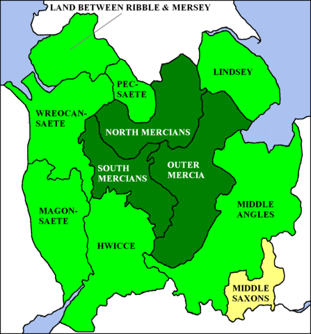
a Map of Kingdom of Mercia, England. from en:wp, [1].
ライセンス[編集]
| このファイルはクリエイティブ・コモンズ 表示-継承 3.0 非移植ライセンスのもとに利用を許諾されています。 著作権に示した解釈の下ライセンスされるものとします。 | ||
| ||
| このライセンスのテンプレートは、GFDLのライセンス・アップデートによりこのファイルに追加されたものです。 |

|
この文書は、フリーソフトウェア財団発行のGNUフリー文書利用許諾書 (GNU Free Documentation License) 1.2またはそれ以降のバージョンの規約に基づき、複製や再配布、改変が許可されます。不可変更部分、表紙、背表紙はありません。このライセンスの複製は、GNUフリー文書利用許諾書という章に含まれています。 著作権に示した解釈の下ライセンスされるものとします。 |
| 解説 | I created this image. The en:Kingdom of Mercia at its greatest extent (7th to 9th centuries) is shown in green, with the original core area (6th century) given a darker tint. TharkunColl 16:23, 6 June 2006 (UTC) |
| 日付 | 2006年6月6日 (当初のアップロード日) |
| 原典 | en.wikipedia からコモンズに移動されました。 |
| 作者 | 英語版ウィキペディアのTharkunCollさん |

|
このhistorical map画像は、ベクターイメージである SVG ファイルとして再作成されるべきです。これにはいくつかの利点があります。詳しくはCommons:Media for cleanupを参照してください。この画像の SVG 形式がすでに利用可能である場合は、アップロードしてください。アップロード後、この画像にあるこのテンプレートを{{Vector version available|新しい画像ファイル名.svg}}テンプレートで置き換えてください。
|
ライセンス[編集]
|
NOTE: "subject to disclaimers" below may not actually apply, this was tagged with {{GFDL-user-en}}, and after May 2007, en:Template:GFDL-self did not require disclaimers. Please check the image description page on the English Wikipedia (or, if it has been deleted, ask an English Wikipedia administrator). See Wikipedia:GFDL standardization for details. | ||||||||
この作品の著作権者であるTharkunColl (英語版ウィキペディアの利用者)は、この作品を以下のライセンスで提供しています。
| ||||||||
|
Note: This tag should not be used. For images that were released on the English Wikipedia using either GFDL or GFDL-self with disclaimers, use {{GFDL-user-en-with-disclaimers}}. For images without disclaimers please use {{GFDL-user-en-no-disclaimers}} instead. If you are the copyright holder of files that were released on Wikipedia, please consider removing the disclaimers. |

![[1]](https://en.wikipedia.org/wiki/Image:Kingdom_of_Mercia.png)
元のアップロードログ[編集]
- 2006-06-06 16:19 TharkunColl 404×505×8 (126328 bytes) I created this image.
ファイルの履歴
過去の版のファイルを表示するには、その版の日時をクリックしてください。
| 日付と時刻 | サムネイル | 寸法 | 利用者 | コメント | |
|---|---|---|---|---|---|
| 現在の版 | 2012年10月13日 (土) 12:37 | | 1,278 × 1,373 (124キロバイト) | Jaybear (トーク | 投稿記録) | Sea-areas colored in lightblue; |
| 2009年6月15日 (月) 11:21 |  | 1,278 × 1,373 (104キロバイト) | Filipo (トーク | 投稿記録) | {{ShouldBeSVG|map}} Created by en:User:TharkunColl for English Wikipedia. The Kingdom of Mercia at its greatest extent (7th to 9th centuries) is shown in green, with the original core area (6th century) given a darker tint. {{GFDL-user-w|en|En | |
| 2006年6月7日 (水) 05:06 |  | 404 × 505 (123キロバイト) | S kitahashi (トーク | 投稿記録) | a Map of Kingdom of Mercia, England. Mercia |
このファイルは上書きできません。
ファイルの使用状況
以下の 3 ページがこのファイルを使用しています:
グローバルなファイル使用状況
以下に挙げる他のウィキがこの画像を使っています:
- be-tarask.wikipedia.org での使用状況
- be.wikipedia.org での使用状況
- ca.wikipedia.org での使用状況
- cy.wikipedia.org での使用状況
- da.wikipedia.org での使用状況
- de.wikipedia.org での使用状況
- el.wikipedia.org での使用状況
- en.wikipedia.org での使用状況
- eo.wikipedia.org での使用状況
- es.wikipedia.org での使用状況
- eu.wikipedia.org での使用状況
- fy.wikipedia.org での使用状況
- ga.wikipedia.org での使用状況
- gl.wikipedia.org での使用状況
- it.wikipedia.org での使用状況
- ja.wikipedia.org での使用状況
- la.wikipedia.org での使用状況
- nds.wikipedia.org での使用状況
- nl.wikipedia.org での使用状況
- nn.wikipedia.org での使用状況
- no.wikipedia.org での使用状況
- ro.wikipedia.org での使用状況
- sh.wikipedia.org での使用状況
- simple.wikipedia.org での使用状況
- th.wikipedia.org での使用状況
- uk.wikipedia.org での使用状況
- zh.wikipedia.org での使用状況