File:Kingdom of Mercia.png

原始檔案 (1,278 × 1,373 像素,檔案大小:124 KB,MIME 類型:image/png)
說明
說明
摘要
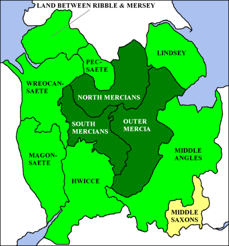
[編輯]a Map of Kingdom of Mercia, England. from en:wp, [1].
授權條款
[編輯]| 此檔案採用共享創意 姓名標示-相同方式分享 3.0 未在地化版本授權條款。 受免責聲明的約束。 | ||
| ||
| 已新增授權條款標題至此檔案,作為GFDL授權更新的一部份。 |

|
已授權您依據自由軟體基金會發行的無固定段落、封面文字和封底文字GNU自由文件授權條款1.2版或任意後續版本,對本檔進行複製、傳播和/或修改。該協議的副本列在GNU自由文件授權條款中。 受免責聲明的約束。 |
| 描述 | I created this image. The en:Kingdom of Mercia at its greatest extent (7th to 9th centuries) is shown in green, with the original core area (6th century) given a darker tint. TharkunColl 16:23, 6 June 2006 (UTC) |
| 日期 | 2006年六月6日 (原始上傳日期) |
| 來源 | Transferred from en.wikipedia to Commons. |
| 作者 | 英文維基百科的TharkunColl |

|
本圖片是以PNG、GIF或JPEG格式上傳。然而,其中包含的資料或訊息,應該重新建立成可縮放向量圖形(SVG)檔案,以更有效率或更準確的方式儲存。如有可能,請上傳本圖片的SVG格式版本。在上傳之後,請修改維基各姊妹計畫中所有使用舊版圖片的條目(列在圖像連結章節中),替換為新版圖片,並在舊圖片的描述頁中加入{{Vector version available|新圖片名稱.svg}}模板,同時移除本模板。
|
授權條款
[編輯]|
NOTE: "subject to disclaimers" below may not actually apply, this was tagged with {{GFDL-user-en}}, and after May 2007, en:Template:GFDL-self did not require disclaimers. Please check the image description page on the English Wikipedia (or, if it has been deleted, ask an English Wikipedia administrator). See Wikipedia:GFDL standardization for details. | ||||||||
TharkunColl 位于英语维基百科,此作品的版權所有人,決定用以下授權條款發佈本作品:
| ||||||||
|
Note: This tag should not be used. For images that were released on the English Wikipedia using either GFDL or GFDL-self with disclaimers, use {{GFDL-user-en-with-disclaimers}}. For images without disclaimers please use {{GFDL-user-en-no-disclaimers}} instead. If you are the copyright holder of files that were released on Wikipedia, please consider removing the disclaimers. |

![[1]](https://en.wikipedia.org/wiki/Image:Kingdom_of_Mercia.png)
原始上傳日誌
[編輯]
- 2006-06-06 16:19 TharkunColl 404×505×8 (126328 bytes) I created this image.
檔案歷史
點選日期/時間以檢視該時間的檔案版本。
| 日期/時間 | 縮圖 | 尺寸 | 用戶 | 備註 | |
|---|---|---|---|---|---|
| 目前 | 2012年10月13日 (六) 12:37 | | 1,278 × 1,373(124 KB) | Jaybear(對話 | 貢獻) | Sea-areas colored in lightblue; |
| 2009年6月15日 (一) 11:21 |  | 1,278 × 1,373(104 KB) | Filipo(對話 | 貢獻) | {{ShouldBeSVG|map}} Created by en:User:TharkunColl for English Wikipedia. The Kingdom of Mercia at its greatest extent (7th to 9th centuries) is shown in green, with the original core area (6th century) given a darker tint. {{GFDL-user-w|en|En | |
| 2006年6月7日 (三) 05:06 |  | 404 × 505(123 KB) | S kitahashi(對話 | 貢獻) | a Map of Kingdom of Mercia, England. Mercia |
無法覆蓋此檔案。
檔案用途
下列3個頁面有用到此檔案:
全域檔案使用狀況
以下其他 wiki 使用了這個檔案:
- be-tarask.wikipedia.org 的使用狀況
- be.wikipedia.org 的使用狀況
- ca.wikipedia.org 的使用狀況
- cy.wikipedia.org 的使用狀況
- da.wikipedia.org 的使用狀況
- de.wikipedia.org 的使用狀況
- el.wikipedia.org 的使用狀況
- en.wikipedia.org 的使用狀況
- eo.wikipedia.org 的使用狀況
- es.wikipedia.org 的使用狀況
- eu.wikipedia.org 的使用狀況
- fy.wikipedia.org 的使用狀況
- ga.wikipedia.org 的使用狀況
- gl.wikipedia.org 的使用狀況
- it.wikipedia.org 的使用狀況
- ja.wikipedia.org 的使用狀況
- la.wikipedia.org 的使用狀況
- nds.wikipedia.org 的使用狀況
- nl.wikipedia.org 的使用狀況
- nn.wikipedia.org 的使用狀況
- no.wikipedia.org 的使用狀況
- ro.wikipedia.org 的使用狀況
- sh.wikipedia.org 的使用狀況
- simple.wikipedia.org 的使用狀況
- th.wikipedia.org 的使用狀況
- uk.wikipedia.org 的使用狀況
- zh.wikipedia.org 的使用狀況