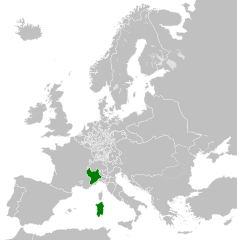
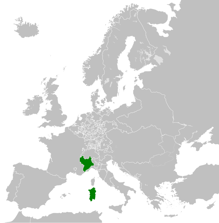
File:Kingdom of Sardinia 1789.svg
Pāriet uz navigāciju
Pāriet uz meklēšanu

Size of this PNG preview of this SVG file: 450 × 456 pikseļi. Citi izmēri: 237 × 240 pikseļi | 474 × 480 pikseļi | 758 × 768 pikseļi | 1 011 × 1 024 pikseļi | 2 021 × 2 048 pikseļi.
Sākotnējais fails (SVG fails, definētais izmērs 450 × 456 pikseļi, faila izmērs: 799 KB)
Captions
Captions
Pievieno vienas rindiņas aprakstu, ko šis fails attēlo
Kopsavilkums
[labot šo sadaļu]


.svg)
.svg)
.svg)
.svg)
.svg)


.svg)
.svg)
.svg)


.png)
.png)


.svg)


.svg)

.svg)


.svg)
.svg)
.svg)
.svg)


.svg)
.png)


.svg)


.svg)
.svg)


.svg)


.svg)


.svg)
.svg)
.svg)
.svg)
.svg)
.svg)
.svg)
_cropped.svg)
.svg)
.svg)
.svg)
.svg)
.svg)
.svg)
.svg)
.svg)
.svg)
.svg)
.svg)
.svg)
.svg)
.svg)
.svg)
.svg)
.svg)
.svg)
.svg)
.svg)
.svg)
.svg)
.svg)
.svg)
.svg)
.svg)
.svg)
.svg)
.svg)
.svg)
.svg)
.svg)
.svg)
.svg)
.svg)
.svg)
.svg)
.svg)
.svg)
.svg)
.svg)
.svg)
.svg)
.svg)
.svg)
Licence
[labot šo sadaļu]
Es, šī darba autortiesību īpašnieks, publicēju to saskaņā ar šo licenci:
Šis fails tiek izplatīts saskaņā ar licences Creative Commons Atsauce-Līdzīgi Noteikumi 3.0 Vispārējiem noteikumiem.
- Jūs varat brīvi:
- koplietot – kopēt, izplatīt un pārraidīt darbu
- remiksēt – pielāgot darbu
- Saskaņā ar šādiem nosacījumiem:
- atsaucoties – Tev ir jānorāda autors, saite uz licenci un to, vai veiktas kādas izmaiņas. To var darīt jebkādā saprātīgā veidā, bet ne tādā, kas norādītu, ka licencētājs atbalsta tevi vai veidu, kā tu izmanto šo darbu.
- nemainot licenci – Ja tu miksē, pārveido vai izmanto materiālu, tev savs devums jāpublicē ar to pašu vai saderīgu licenci kā oriģināls.
Original upload log
[labot šo sadaļu]
This image is a derivative work of the following images:
- File:Europe_1789.svg licensed with Cc-by-sa-3.0
- 2013-04-14T03:44:26Z Alphathon 450x456 (858577 Bytes) Corrected some errors in northern Italy
- 2013-04-14T01:38:01Z Alphathon 450x456 (853881 Bytes) tweaked again
- 2013-04-14T01:36:10Z Alphathon 450x456 (853881 Bytes) Tweaked Holy Roman Empire border style
- 2013-04-14T01:33:26Z Alphathon 450x456 (853857 Bytes) == {{int:filedesc}} == {{Information |Description={{en|A blank Map of Europe circa 1789. This map also includes a border for the [[:en:Holy Roman Empire|Holy Roman Empire]]. Since there are so many small German states, they h
Uploaded with derivativeFX
Faila hronoloģija
Uzklikšķini uz datums/laiks kolonnā esošās saites, lai apskatītos, kā šis fails izskatījās tad.
| Datums/Laiks | Attēls | Izmēri | Dalībnieks | Komentārs | |
|---|---|---|---|---|---|
| tagadējais | 2021. gada 17. oktobris, plkst. 08.00 | | 450 × 456 (799 KB) | Fenn-O-maniC (diskusija | devums) | Fixed the Russo-Swedish border to match the Treaty of Åbo of 1743 |
| 2013. gada 18. aprīlis, plkst. 17.10 |  | 450 × 456 (820 KB) | Alphathon (diskusija | devums) | Various fixes | |
| 2013. gada 18. aprīlis, plkst. 14.43 |  | 450 × 456 (817 KB) | Alphathon (diskusija | devums) | Fixed Scandinavian borders | |
| 2013. gada 14. aprīlis, plkst. 13.54 |  | 450 × 456 (802 KB) | Alphathon (diskusija | devums) | == {{int:filedesc}} == {{Information |Description={{en|A map of the Kingdom of Sardinia circa 1789}}{{de|Eine Landkarte das Königreich Sardinien c. 1789.}} |Source={{Derived from|Europe_1789.sv... |
Šo failu nevar pārrakstīt.
Faila lietojums
Šo failu neizmanto nevienā lapā.
Globālais faila lietojums
Šīs Vikipēdijas izmanto šo failu:
- Izmantojums en.wikipedia.org
- Izmantojums pl.wikipedia.org