File:Kishiwada city center area Aerial photograph.1985.jpg
Salta a la navegació
Salta a la cerca

Mida d'aquesta previsualització: 644 × 600 píxels. Altres resolucions: 258 × 240 píxels | 516 × 480 píxels | 825 × 768 píxels | 1.100 × 1.024 píxels | 2.200 × 2.048 píxels | 5.762 × 5.364 píxels.
Fitxer original (5.762 × 5.364 píxels, mida del fitxer: 24,27 Mo, tipus MIME: image/jpeg)
Llegendes
Llegendes
Afegeix una explicació d'una línia del que representa aquest fitxer
Resum
[modifica]
| Descripció |
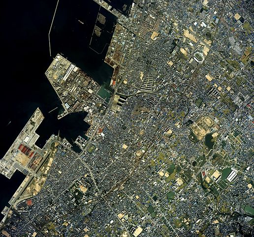
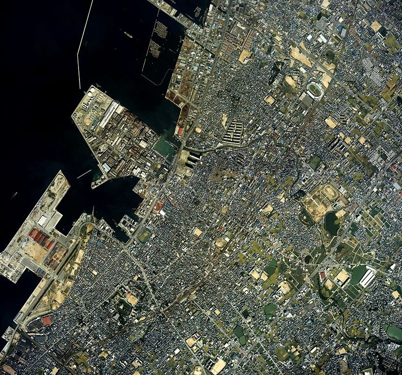
English: Kishiwada city center area Aerial photograph.1985
日本語: 岸和田市(大阪府)中心部周辺の空中写真。ckk-85-2_c8の3,4,5、ckk-85-2_c9の4,5,6、合計6枚を合成作成。 |
| Data | |
| Font | 国土情報ウェブマッピングシステム |
| Autor | 国土交通省 |
Llicència
[modifica]

|
El titular dels drets d'autor d'aquest arxiu, the Ministry of Land, Infrastructure, Transport and Tourism of Japan, permet que qualsevol pugui usar-lo per a qualsevol propòsit, sempre que el titular dels drets d'autor sigui reconegut correctament. La redistribució, les obres derivades, l'ús comercial, i qualsevol altre ús està permès. |
Reconeixement:
Copyright © National Land Image Information (Color Aerial Photographs), Ministry of Land, Infrastructure, Transport and Tourism
|
 |
This image is copyrighted by the Ministry of Land, Infrastructure, Transport and Tourism of Japan. For terms of use, see the stipulation to use of National Land Information (in Japanese) and message from MLIT (in Japanese and English). When you display this image on an article, include the following phrase in the description: "Made based on National Land Image Information (Color Aerial Photographs), Ministry of Land, Infrastructure, Transport and Tourism".
|
Historial del fitxer
Cliqueu una data/hora per veure el fitxer tal com era aleshores.
| Data/hora | Miniatura | Dimensions | Usuari/a | Comentari | |
|---|---|---|---|---|---|
| actual | 02:30, 15 març 2014 | | 5.762 × 5.364 (24,27 Mo) | さかおり (discussió | contribucions) | {{Information |Description ={{en|1=Kishiwada city center area Aerial photograph.1985}} {{ja|1=岸和田市(大阪府)中心部周辺の空中写真。ckk-85-2_c8の3,4,5、ckk-85-2_c9の4,5,6、合計6枚を合成作成。}} |Source =国... |
No podeu sobreescriure aquest fitxer.
Ús del fitxer
Les 3 pàgines següents utilitzen aquest fitxer:
Ús global del fitxer
Utilització d'aquest fitxer en altres wikis:
- Utilització a ca.wikipedia.org
- Utilització a ce.wikipedia.org
- Utilització a fi.wikipedia.org
- Utilització a gl.wikipedia.org
- Utilització a ja.wikipedia.org
- Utilització a tt.wikipedia.org
- Utilització a www.wikidata.org