File:Koppen-Geiger Map TUR present.svg
跳转到导航
跳转到搜索

此SVG文件的PNG预览的大小:800 × 374像素。 其他分辨率:320 × 150像素 | 640 × 300像素 | 1,024 × 479像素 | 1,280 × 599像素 | 2,560 × 1,198像素 | 1,816 × 850像素。
原始文件 (SVG文件,尺寸为1,816 × 850像素,文件大小:1.47 MB)
说明
说明
添加一行文字以描述该文件所表现的内容
摘要
[编辑]
| 描述 |
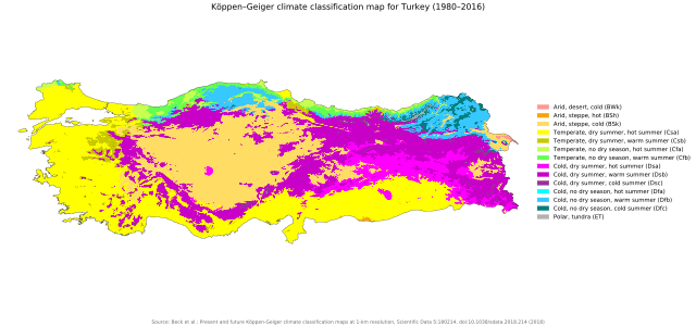
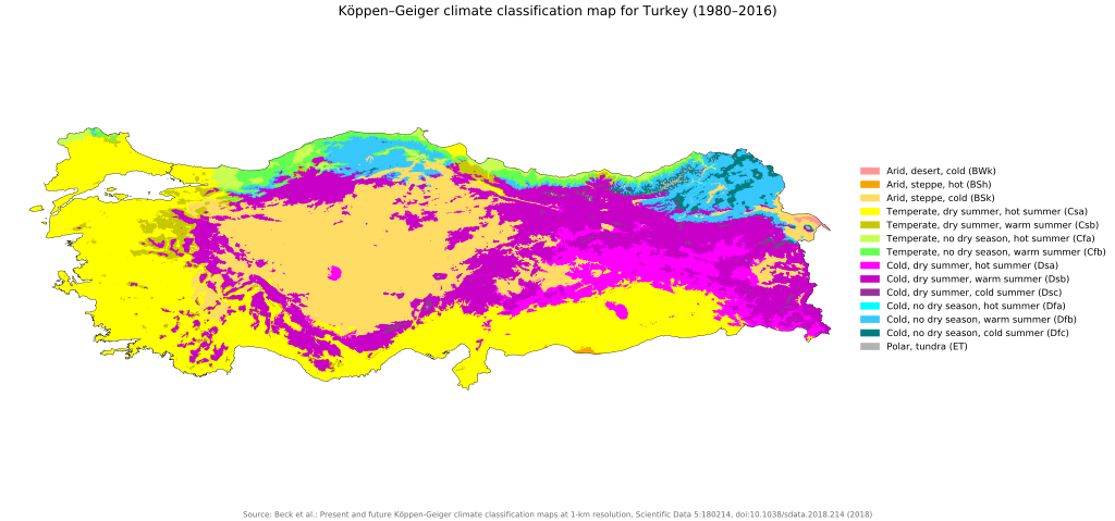
English: Köppen–Geiger climate classification map for Turkey |
| 日期 | |
| 来源 | "Present and future Köppen-Geiger climate classification maps at 1-km resolution". Nature Scientific Data. DOI:10.1038/sdata.2018.214. |
| 作者 | Beck, H.E., Zimmermann, N. E., McVicar, T. R., Vergopolan, N., Berg, A., & Wood, E. F. |
许可协议
[编辑]
| 相机位置 | | 在以下服务上查看本图像和附近其他图像: OpenStreetMap |
|---|
文件历史
点击某个日期/时间查看对应时刻的文件。
| 日期/时间 | 缩略图 | 大小 | 用户 | 备注 | |
|---|---|---|---|---|---|
| 当前 | 2018年11月26日 (一) 05:44 | | 1,816 × 850(1.47 MB) | NVergopolan(留言 | 贡献) | {{Information |Description={{en| Köppen–Geiger climate classification map for Turkey}}|date=2018-11-06|source={{cite journal | title=Present and future Köppen-Geiger climate classification maps at 1-km resolution | journal=Nature Scientific Data |doi=10.1038/sdata.2018.214}}|author=Beck, H.E., Zimmermann, N. E., McVicar, T. R., Vergopolan, N., Berg, A., & Wood, E. F.|permission=|other_versions=|other_fields=}}{{Cc-by-4.0}}{{Location|38.961040495|35.25006199}}[[Category:Köppen-Geiger Climate C... |
您不可以覆盖此文件。
文件用途
全域文件用途
以下其他wiki使用此文件:
- az.wikipedia.org上的用途
- ca.wikipedia.org上的用途
- cy.wikipedia.org上的用途
- en.wikipedia.org上的用途
- es.wikipedia.org上的用途
- fa.wikipedia.org上的用途
- it.wikipedia.org上的用途
- ko.wikipedia.org上的用途
- ku.wikipedia.org上的用途
- mk.wikipedia.org上的用途
- sr.wikipedia.org上的用途
- tr.wikipedia.org上的用途
- uk.wikipedia.org上的用途
- zh.wikipedia.org上的用途