File:Koxinga territory.jpg
跳去導覽
跳去搵嘢

預覽大細:800 × 598 像素。 第啲解像度:320 × 239 像素 | 640 × 478 像素 | 1,000 × 747 像素。
原本檔案 (1,000 × 747 像素,檔案大細:339 KB ,MIME類型:image/jpeg)
Captions
Captions
Add a one-line explanation of what this file represents


|
This map image could be recreated using vector graphics as an SVG file. This has several advantages; see Commons:Media for cleanup for more information. If an SVG form of this image is already available, please upload it. After uploading an SVG, replace this template with {{vector version available|new image name.svg}}.
|
摘要[編輯]
協議[編輯]
I, the copyright holder of this work, hereby publish it under the following licenses:

|
根據自由軟體基金會發佈嘅無固定段落、封面文字同封底文字GNU自由文件授權條款第1.2或打後嘅版本,你獲授權可以重製、散佈同埋修改爾份文件。授權條款嘅副本喺章節GNU自由文件授權條款。 |
This file is licensed under the Creative Commons Attribution-Share Alike 3.0 Unported, 2.5 Generic, 2.0 Generic and 1.0 Generic license.
- 你可以:
- 去分享 – 複製、發佈同傳播呢個作品
- 再改 – 創作演繹作品
- 要遵照下面嘅條件:
- 署名 – 你一定要畀合適嘅表彰、畀返指向呢個授權條款嘅連結,同埋寫明有無改過嚟。你可以用任何合理方式去做,但唔可以用任何方式暗示授權人認可咗你或者你嘅使用方式。
- 相同方式分享 – 如果你用任何方式改過呢個作品,你必須要用返原本或者相似嘅條款發佈。
你可以揀你想用嘅牌照。
檔案歷史
撳個日期/時間去睇響嗰個時間出現過嘅檔案。
| 日期/時間 | 縮圖 | 尺寸 | 用戶 | 註解 | |
|---|---|---|---|---|---|
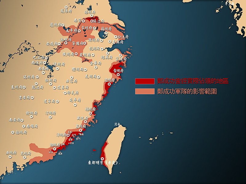
| 現時 | 2008年9月18號 (四) 15:02 | | 1,000 × 747(339 KB) | Ifatson~commonswiki(傾偈 | 貢獻) | {{Information |Description={{zh-tw|1=鄭成功勢力範圍與中國東南沿海地圖。}} |Source=Own work by uploader |Author=Ifatson |Date= |Permission= |other_versions= }} <!--{{ImageUpload|full}}--> |
你無得衾咗個檔案。
檔案用途
以下嘅1版用到呢個檔:
全域檔案使用情況
下面嘅維基都用緊呢個檔案:
- de.wikipedia.org嘅使用情況
- en.wikipedia.org嘅使用情況
- es.wikipedia.org嘅使用情況
- fr.wikipedia.org嘅使用情況
- ja.wikipedia.org嘅使用情況
- ko.wikipedia.org嘅使用情況
- lt.wikipedia.org嘅使用情況
- nl.wikipedia.org嘅使用情況
- no.wikipedia.org嘅使用情況
- pt.wikipedia.org嘅使用情況
- ru.wikipedia.org嘅使用情況
- uk.wikipedia.org嘅使用情況
- uz.wikipedia.org嘅使用情況
- vi.wikipedia.org嘅使用情況
- wuu.wikipedia.org嘅使用情況
- zh-classical.wikipedia.org嘅使用情況
- zh-min-nan.wikipedia.org嘅使用情況
- zh-yue.wikipedia.org嘅使用情況
- zh.wikipedia.org嘅使用情況