File:Kwajalein Atoll 2003-02-07 - Landsat 7 - 30m.png

原始檔案 (3,786 × 2,876 像素,檔案大小:12.22 MB,MIME 類型:image/png)
說明
說明
摘要
[編輯]
| 描述 |
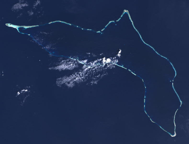
English: Composite "true color" multispectral satellite image of Kwajalein Atoll, Republic of Marshall Islands.
NASA Landsat 7 ETM+ bands used were 3 (red), 2 (green) and 1 (blue), and the image was pan-sharpened to 15m resolution, manually color balanced, and resampled to 30m output resolution. Projection: UTM (zone 58), WGS84. Imagery courtesy NASA/USGS. Much of what appears to be land in this image is actually underwater, you can see the blue tint to those areas. Kwajalein Island is the southernmost island, at the bottom right of the image. This is the center of US operations in the atoll, and the most heavily settled. Directly above it is Ebeye, the main Marshallese settlement in the atoll. A causeway runs north from Ebeye to create a string of connected islands. Some distance to the north of Ebeye, just below the middle of the right side of the image, are three small islands roughly in a triangle. The southeastern one is Meck Island, which holds a major US Army rocket testing facility. Launches are sometimes carried out from Omelek, the next island north of the cluster of three. Roi-Namur island, the second largest in the atoll, forms the northernmost location in the atoll, roughly top-center in the image. It hosts a number of large radars originally set up by ARPA and Lincoln Laboratories, but later turned over to the Army. On the extreme left is Ebadon, formerly the second largest island in the atoll before Roe and Namur were backfilled to turn them into one larger island. This island, along with a few islands to its east, were formerly a major Marshallese settlement, but many of the people moved to be closer to the US installations. The long string of islands between Ebadon and Kwajalein are relatively scarcely settled. Illegini, just east of due south of Roi-Namur, roughly the mid-point of the chain, used to be used for missile testing in conjunction with Meck, but now is used only for remote radar and camera systems. |
| 日期 | |
| 來源 | NASA/USGS Landsat satellite image GeoTIFF archive, http://glovis.usgs.gov |
| 作者 | NASA |
| 拍攝地點 | | 位於此地的本圖片與其他圖片: OpenStreetMap |
|---|
Per-channel manual histogram stretch, 0.3 wt unsharp mask, mild saturation / contrast adjustments. ImageJ, pngcrush.
授權條款
[編輯]
| 本作品由NASA創作,屬於公有領域。根據NASA的版權政策:“NASA的創作除非另有聲明否則不受版權保護。”(參見:Template:PD-USGov/zh,NASA版權政策或JPL圖像使用政策) | ||
 |
警告:
|
檔案歷史
點選日期/時間以檢視該時間的檔案版本。
| 日期/時間 | 縮圖 | 尺寸 | 用戶 | 備註 | |
|---|---|---|---|---|---|
| 目前 | 2014年7月7日 (一) 18:40 | | 3,786 × 2,876(12.22 MB) | Разрывные(對話 | 貢獻) | User created page with UploadWizard |
無法覆蓋此檔案。
檔案用途
下列頁面有用到此檔案:
全域檔案使用狀況
以下其他 wiki 使用了這個檔案:
- ar.wikipedia.org 的使用狀況
- ast.wikipedia.org 的使用狀況
- ca.wikipedia.org 的使用狀況
- ceb.wikipedia.org 的使用狀況
- en.wikipedia.org 的使用狀況
- en.wikivoyage.org 的使用狀況
- es.wikipedia.org 的使用狀況
- eu.wikipedia.org 的使用狀況
- fr.wikipedia.org 的使用狀況
- fr.wiktionary.org 的使用狀況
- he.wikipedia.org 的使用狀況
- he.wikivoyage.org 的使用狀況
- hu.wikipedia.org 的使用狀況
- id.wikipedia.org 的使用狀況
- it.wikivoyage.org 的使用狀況
- ja.wikivoyage.org 的使用狀況
- ka.wikipedia.org 的使用狀況
- lv.wikipedia.org 的使用狀況
- mt.wikipedia.org 的使用狀況
- pl.wikipedia.org 的使用狀況
- ro.wikipedia.org 的使用狀況
- ru.wikinews.org 的使用狀況
- simple.wikipedia.org 的使用狀況
- tr.wikipedia.org 的使用狀況
- uk.wikipedia.org 的使用狀況
- ur.wikipedia.org 的使用狀況
- www.wikidata.org 的使用狀況
- zh.wikipedia.org 的使用狀況
- zh.wikivoyage.org 的使用狀況