File:Lake Athabasca, Canada.jpg
Aller à la navigation
Aller à la recherche

Taille de cet aperçu : 800 × 338 pixels. Autres résolutions : 320 × 135 pixels | 640 × 270 pixels | 1 156 × 488 pixels.
Fichier d’origine (1 156 × 488 pixels, taille du fichier : 173 kio, type MIME : image/jpeg)
Légendes
Légendes
Ajoutez en une ligne la description de ce que représente ce fichier
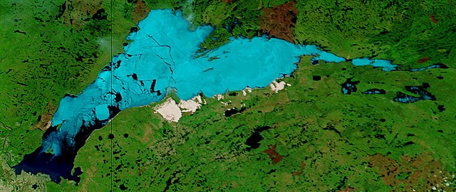
Lake Athabasca, Canada. Lake Athabasca straddles the border between Alberta (west) and Saskatchewan (east) - the black line. In the false-color image, vegetation is green, water is dark blue, and ice (or snow) is light blue.
Description
[modifier]
| Description | Lake Athabasca, Canada. Lake Athabasca straddles the border between Alberta (west) and Saskatchewan (east) - the black line. In the false-color image, vegetation is green, water is dark blue, and ice (or snow) is light blue. |
| Date | Visualization Date: 2002-06-18 |
| Source | Visible Earth, NASA (extract) |
| Auteur | Jacques Descloitres, MODIS Land Rapid Response Team, NASA/GSFC |
Cropped from the original 4800 x 3600 JPEG (4.4MB) image.
Conditions d’utilisation
[modifier]
| Ce fichier provient de la NASA. Sauf exception, les documents créés par la NASA ne sont pas soumis à copyright. Pour plus d'informations, voir la politique de copyright de la NASA. | ||
 |
Attention :
|
Historique du fichier
Cliquer sur une date et heure pour voir le fichier tel qu'il était à ce moment-là.
| Date et heure | Vignette | Dimensions | Utilisateur | Commentaire | |
|---|---|---|---|---|---|
| actuel | 18 août 2006 à 11:37 | | 1 156 × 488 (173 kio) | Feydey (d | contributions) | {{Information |Description= Lake Athabasca, Canada. Lake Athabasca straddles the border between Alberta (west) and Saskatchewan (east) - the black line. In the false-color image, vegetation is green, water is dark blue, and ice (or snow) is light blue. |S |
Vous ne pouvez pas remplacer ce fichier.
Utilisations locales du fichier
Les 2 pages suivantes utilisent ce fichier :
Utilisations du fichier sur d’autres wikis
Les autres wikis suivants utilisent ce fichier :
- Utilisation sur af.wikipedia.org
- Utilisation sur ar.wikipedia.org
- Utilisation sur arz.wikipedia.org
- Utilisation sur be.wikipedia.org
- Utilisation sur bg.wikipedia.org
- Utilisation sur bn.wikipedia.org
- Utilisation sur bs.wikipedia.org
- Utilisation sur ca.wikipedia.org
- Utilisation sur ceb.wikipedia.org
- Utilisation sur cv.wikipedia.org
- Utilisation sur cy.wikipedia.org
- Utilisation sur da.wikipedia.org
- Utilisation sur el.wikipedia.org
- Utilisation sur en.wikipedia.org
- Utilisation sur eo.wikipedia.org
- Utilisation sur es.wikipedia.org
- Utilisation sur eu.wikipedia.org
- Utilisation sur fa.wikipedia.org
- Utilisation sur frr.wikipedia.org
- Utilisation sur fr.wikipedia.org
- Utilisation sur fy.wikipedia.org
- Utilisation sur hu.wikipedia.org
- Utilisation sur hy.wikipedia.org
- Utilisation sur id.wikipedia.org
- Utilisation sur incubator.wikimedia.org
- Utilisation sur it.wikipedia.org
- Utilisation sur ka.wikipedia.org
- Utilisation sur kk.wikipedia.org
- Utilisation sur ky.wikipedia.org
- Utilisation sur lt.wikipedia.org
- Utilisation sur lv.wikipedia.org
- Utilisation sur nl.wikipedia.org
- Utilisation sur no.wikipedia.org
- Utilisation sur pl.wikipedia.org
- Utilisation sur pl.wiktionary.org
- Utilisation sur pnb.wikipedia.org
- Utilisation sur pt.wikipedia.org
- Utilisation sur ro.wikipedia.org
- Utilisation sur ru.wikipedia.org
- Utilisation sur sv.wikipedia.org
Voir davantage sur l’utilisation globale de ce fichier.