File:Lake Manly system.png
Zur Navigation springen
Zur Suche springen
Es ist keine höhere Auflösung vorhanden.
Lake_Manly_system.png (290 × 315 Pixel, Dateigröße: 16 KB, MIME-Typ: image/png)
Bildtexte
Kurzbeschreibungen
Ergänze eine einzeilige Erklärung, was diese Datei darstellt.
| Beschreibung |
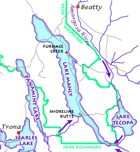
English: The Lake Manly lake system as it might have looked during its last maximum extent 22,000 years ago. (USGS image). The Lake Manly lake system as it might have looked during its last maximum extent 22,000 years ago. Arrows indicate river water flow, gray lines are current highways, and red dots are towns. (USGS image). The Lake Manly lake system as it might have looked during its last maximum extent 22,000 years ago. (USGS image).
Français : Le Lac Manly tel qu'il devait être à son extension maximale, il y a 22 000 années. (Document de l'USGS).
Magyar: A Manly-tó és a környező vízrendszer kb. 22 000 évvel ezelőtt.
Български: Най-вероятно така е изглеждала Долината на смъртта преди 22 000 години. |
|||||||||
| Quelle |
Death Valley Geology Field Trip: Shoreline Butte: |
|||||||||
| Genehmigung (Weiternutzung dieser Datei) |
|
|||||||||
| Kartografische Angaben | ||||||||||
| Räumliche Begrenzung |
|
|||||||||
| Georeferenzierung | ||||||||||
| Andere Versionen |
|
|||||||||

Dateiversionen
Klicke auf einen Zeitpunkt, um diese Version zu laden.
| Version vom | Vorschaubild | Maße | Benutzer | Kommentar | |
|---|---|---|---|---|---|
| aktuell | 17:43, 23. Feb. 2012 | | 290 × 315 (16 KB) | Ras67 (Diskussion | Beiträge) | cropped |
| 08:48, 12. Mär. 2006 |  | 291 × 316 (17 KB) | Urban~commonswiki (Diskussion | Beiträge) | USGS image from http://www2.nature.nps.gov/geology/usgsnps/deva/ftsho1.html<br><br>{{PD-USGov}} Category:Death Valley |
Du kannst diese Datei nicht überschreiben.
Dateiverwendung
Die folgende Seite verwendet diese Datei:
Globale Dateiverwendung
Die nachfolgenden anderen Wikis verwenden diese Datei:
- Verwendung auf bg.wikipedia.org
- Verwendung auf de.wikipedia.org
- Verwendung auf fr.wikipedia.org
- Verwendung auf he.wikipedia.org
- Verwendung auf hu.wikipedia.org
- Verwendung auf it.wikipedia.org
- Verwendung auf zh.wikipedia.org
Kategorien:
- Geological maps of California
- Geological maps of Nevada
- Lake Manly
- Lakes of California
- Lakes of Nevada
- Maps of Death Valley National Park
- Amargosa River
- Amargosa Desert
- Pleistocene glaciations in the United States
- Pleistocene glacial lakes in North America
- Pleistocene geology of California
- Pleistocene geology of Nevada