File:LanguageMap-Kikongo-Kituba.png
跳至導覽
跳至搜尋

預覽大小:800 × 529 像素。 其他解析度:320 × 212 像素 | 640 × 423 像素 | 1,024 × 677 像素 | 1,420 × 939 像素。
原始檔案 (1,420 × 939 像素,檔案大小:89 KB,MIME 類型:image/png)
說明
說明
添加單行說明來描述出檔案所代表的內容
摘要
[編輯]
| 描述 |
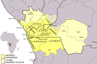
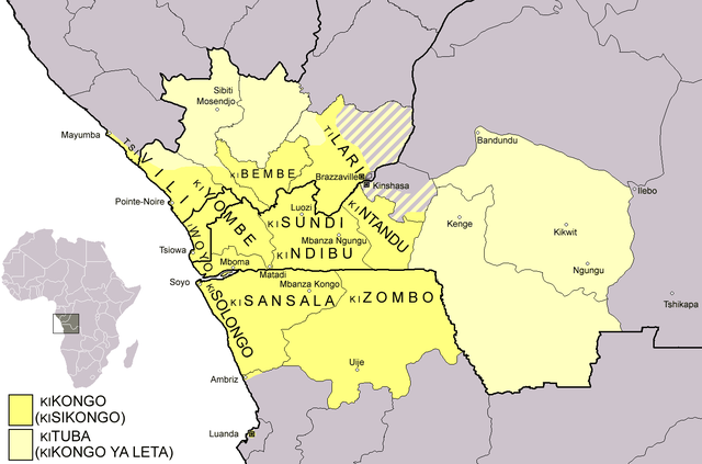
Dialect map of Kikongo. Dark yellow areas are inhabited mainly by first language speakers of the various dialects/languages of Kikongo. Names of some dialects/languages are written on the map. Pale yellow areas are inhabited by first and second language speakers of Kituba (a.k.a. Kikongo ya Leta), which is the lingua franca in the area. Kituba is understood by most speakers of Kikongo. Map drawn by Risto Kupsala. Details are based on the language maps of Ethnologue and several other sources. |
| 日期 | 2006年4月2日 (原始上傳日期) |
| 來源 | 无法识别来源。根据版权声明推断为其自己的作品。 |
| 作者 | 无法识别作者。根据版权声明推断作者为Rasulo~commonswiki。 |
授權條款
[編輯]
| 我,此作品的版權所有人,釋出此作品至公共領域。此授權條款在全世界均適用。 這可能在某些國家不合法,如果是的話: 我授予任何人有權利使用此作品於任何用途,除受法律約束外,不受任何限制。 |
檔案歷史
點選日期/時間以檢視該時間的檔案版本。
| 日期/時間 | 縮圖 | 尺寸 | 用戶 | 備註 | |
|---|---|---|---|---|---|
| 目前 | 2021年2月25日 (四) 00:37 | | 1,420 × 939(89 KB) | Somebody040404(對話 | 貢獻) | Reverted to version as of 10:10, 29 March 2018 (UTC) |
| 2021年2月25日 (四) 00:26 |  | 1,420 × 939(82 KB) | Somebody040404(對話 | 貢獻) | ||
| 2018年3月29日 (四) 10:10 |  | 1,420 × 939(89 KB) | Maphobbyist(對話 | 貢獻) | South Sudan border | |
| 2007年12月20日 (四) 21:24 |  | 1,420 × 939(60 KB) | Rasulo~commonswiki(對話 | 貢獻) | Dialect map of Kikongo. Dark yellow areas are inhabited mainly by native speakers of the various dialects/languages of Ki(si)kongo. Names of some dialects/languages are written on the map. Pale yellow areas are inhabited by first and second language speak | |
| 2006年7月22日 (六) 12:12 |  | 718 × 518(26 KB) | Rasulo~commonswiki(對話 | 貢獻) | ||
| 2006年4月2日 (日) 09:49 |  | 571 × 471(20 KB) | Rasulo~commonswiki(對話 | 貢獻) | Dialect map of Kikongo Dark green areas are inhabited mainly by first language speakers of the various dialects/languages of Kikongo. Names of some dialects/languages are written on the map. Light green areas are inhabited by first and second language spe |
無法覆蓋此檔案。
檔案用途
下列4個頁面有用到此檔案:
全域檔案使用狀況
以下其他 wiki 使用了這個檔案:
- af.wikipedia.org 的使用狀況
- ar.wikipedia.org 的使用狀況
- ast.wikipedia.org 的使用狀況
- az.wiktionary.org 的使用狀況
- bn.wikipedia.org 的使用狀況
- ca.wikipedia.org 的使用狀況
- cs.wikipedia.org 的使用狀況
- da.wikipedia.org 的使用狀況
- de.wikipedia.org 的使用狀況
- en.wikipedia.org 的使用狀況
- eo.wikipedia.org 的使用狀況
- es.wikipedia.org 的使用狀況
- eu.wikipedia.org 的使用狀況
- fi.wikipedia.org 的使用狀況
- frr.wikipedia.org 的使用狀況
- fr.wikipedia.org 的使用狀況
檢視此檔案的更多全域使用狀況。