File:Largest World Subdivisions Area.png
跳转到导航
跳转到搜索
本预览的尺寸:800 × 397像素。 其他分辨率:320 × 159像素 | 640 × 318像素 | 1,024 × 508像素 | 1,280 × 635像素 | 2,560 × 1,271像素 | 4,500 × 2,234像素。
原始文件 (4,500 × 2,234像素,文件大小:566 KB,MIME类型:image/png)
说明
说明
添加一行文字以描述该文件所表现的内容

|
此map图片可使用矢量图形重新创建为SVG文件。这具有很多好处;更多信息请参见共享资源:待清理媒体。如果存在此图片的SVG格式,请将其上传,然后将此模板替换为
{{vector version available|新图片名称}}。
建议您将SVG命名为“Largest World Subdivisions Area.svg”,这样在使用Vector version available(或Vva)模板时就不需要填写新图片名称参数。 |
摘要
[编辑]
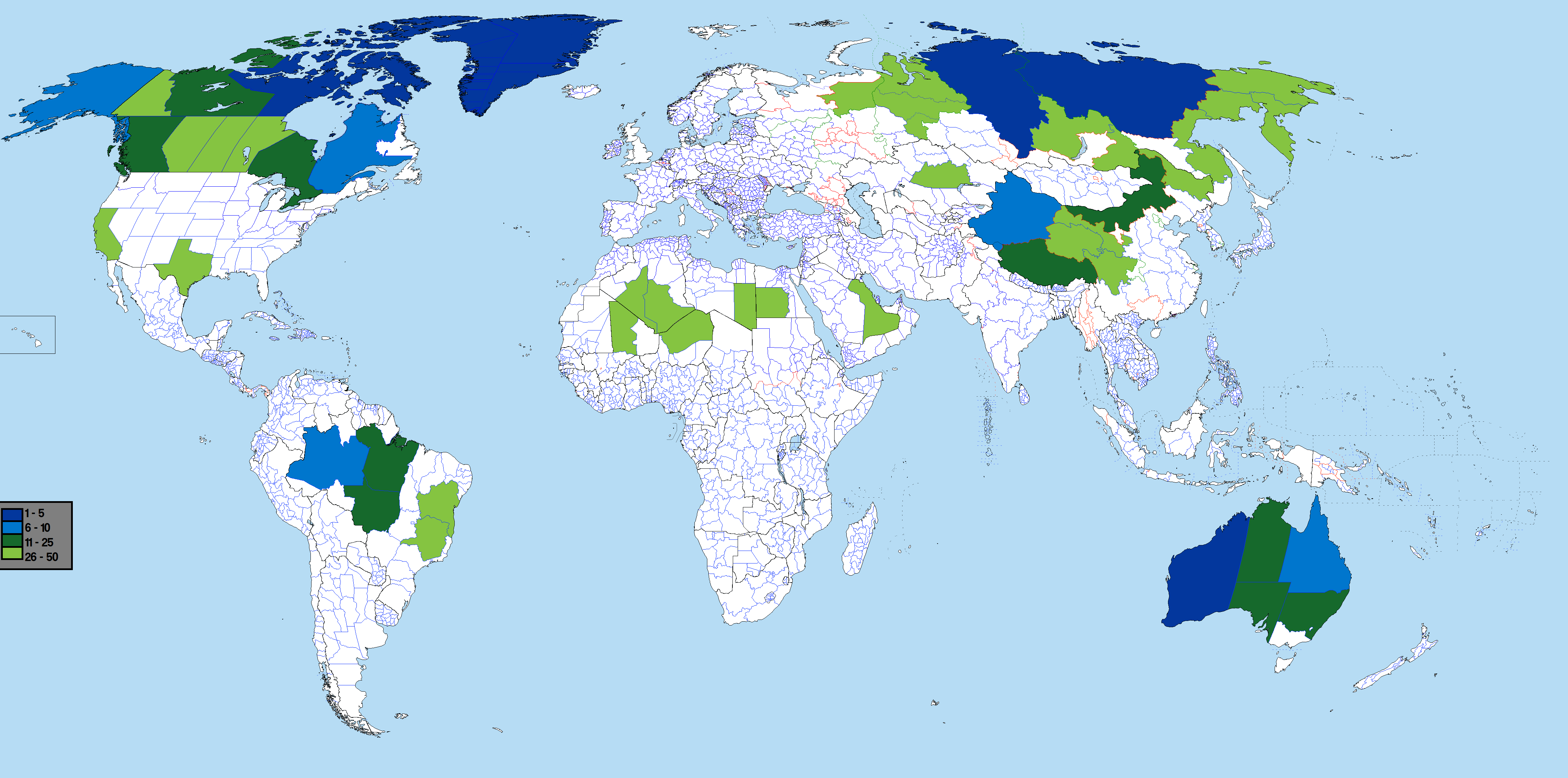
Based on Image:BlankMap-World-Subdivisions.PNG, using information from List of the largest country subdivisions by area
See also: largest subdivisions by population map
许可协议
[编辑]
我,本作品著作权人,特此采用以下许可协议发表本作品:

|
已授权您依据自由软件基金会发行的无固定段落及封面封底文字(Invariant Sections, Front-Cover Texts, and Back-Cover Texts)的GNU自由文件许可协议1.2版或任意后续版本的条款,复制、传播和/或修改本文件。该协议的副本请见“GNU Free Documentation License”。 |
| 本文件采用知识共享署名-相同方式共享 3.0 未本地化版本许可协议授权。 | ||
| ||
| 本许可协议标签作为GFDL许可协议更新的组成部分被添加至本文件。 |
您可以选择您需要的许可协议。
文件历史
点击某个日期/时间查看对应时刻的文件。
| 日期/时间 | 缩略图 | 大小 | 用户 | 备注 | |
|---|---|---|---|---|---|
| 当前 | 2022年2月28日 (一) 09:58 | | 4,500 × 2,234(566 KB) | Scratchinghead(留言 | 贡献) | Congo provinces removed, California re-added |
| 2019年9月1日 (日) 00:35 |  | 4,500 × 2,234(541 KB) | SpencerCS(留言 | 贡献) | Corrected the error. California is no longer highlighted, but the New Valley Governorate is. | |
| 2017年6月13日 (二) 20:37 |  | 4,500 × 2,234(565 KB) | JoaoPedro10029(留言 | 贡献) | Fixed: added table, removed annoying white bar in the far left and pesky colors in the lower left canton. | |
| 2017年6月13日 (二) 20:33 |  | 4,500 × 2,234(332 KB) | JoaoPedro10029(留言 | 贡献) | Bigger map, can see better the subdivisions, only problem is the DRC's subdivisions that are replaced with the 2015's ones. | |
| 2016年7月20日 (三) 15:17 |  | 1,481 × 741(65 KB) | Andhrapur(留言 | 贡献) | update | |
| 2012年10月26日 (五) 00:05 |  | 1,481 × 741(122 KB) | $200inaire(留言 | 贡献) | Second Fix | |
| 2012年10月26日 (五) 00:03 |  | 1,481 × 741(122 KB) | $200inaire(留言 | 贡献) | Color tint | |
| 2012年9月2日 (日) 06:49 |  | 1,481 × 741(81 KB) | ASDFGH(留言 | 贡献) | update | |
| 2012年4月13日 (五) 03:24 |  | 1,427 × 628(144 KB) | $200inaire(留言 | 贡献) | Added the two DRC Provinces Orientale and Katanga. | |
| 2011年11月25日 (五) 17:06 |  | 1,427 × 628(145 KB) | Дмитрий-5-Аверин(留言 | 贡献) | Без Борку-Эннеди-Тибести и Эр-Рияд |
您不可以覆盖此文件。
文件用途
没有页面使用本文件。
全域文件用途
以下其他wiki使用此文件:
- ar.wikipedia.org上的用途
- bn.wikipedia.org上的用途
- ca.wikipedia.org上的用途
- fr.wikipedia.org上的用途
- hu.wikipedia.org上的用途
- ja.wikipedia.org上的用途
- os.wikipedia.org上的用途
- pt.wikipedia.org上的用途
- sq.wikipedia.org上的用途
- th.wikipedia.org上的用途
- uk.wikipedia.org上的用途
- zh.wikipedia.org上的用途