File:Largest counties of the United States by population as of the 2020 United States census.svg
跳转到导航
跳转到搜索

此SVG文件的PNG预览的大小:512 × 324像素。 其他分辨率:320 × 203像素 | 640 × 405像素 | 1,024 × 648像素 | 1,280 × 810像素 | 2,560 × 1,620像素。
原始文件 (SVG文件,尺寸为512 × 324像素,文件大小:867 KB)
说明
说明
添加一行文字以描述该文件所表现的内容
Largest counties of the United States by population as of the 2020 United States census
摘要[编辑]
| 描述 |
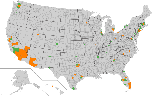
English: Counties with over 1 million inhabitants
Counties with under 1 million inhabitants
A map of the counties of the United States. The 100 most populous counties are highlighted, with those counties having more than one million residents in orange, and those counties having fewer than one million residents in green, as of the April 1, 2020 United States census. |
| 日期 | |
| 来源 | 自己的作品 |
| 作者 | Elli |
| 其他版本 | Map derived from File:Largest counties of the United States by population as of the 2010 United States census.svg |
许可协议[编辑]
| 此地图不符合版权的资格,因此属于公有领域,因为其完全包含公共财产信息,不包含原作者身份。详情参见Commons:Threshold of originality § Maps。
|
文件历史
点击某个日期/时间查看对应时刻的文件。
| 日期/时间 | 缩略图 | 大小 | 用户 | 备注 | |
|---|---|---|---|---|---|
| 当前 | 2021年12月24日 (五) 06:40 | | 512 × 324(867 KB) | Elli(留言 | 贡献) | Uploaded own work with UploadWizard |
您不可以覆盖此文件。
文件用途
没有页面使用本文件。
全域文件用途
以下其他wiki使用此文件:
- cs.wikipedia.org上的用途
- en.wikipedia.org上的用途
- ru.wikipedia.org上的用途
- zh.wikipedia.org上的用途