File:Last Glacial Maximum Vegetation Map.svg
跳转到导航
跳转到搜索

此SVG文件的PNG预览的大小:800 × 533像素。 其他分辨率:320 × 213像素 | 640 × 427像素 | 1,024 × 683像素 | 1,280 × 853像素 | 2,560 × 1,707像素 | 1,200 × 800像素。
原始文件 (SVG文件,尺寸为1,200 × 800像素,文件大小:316 KB)
说明
说明
添加一行文字以描述该文件所表现的内容
摘要
[编辑]
| 描述 |
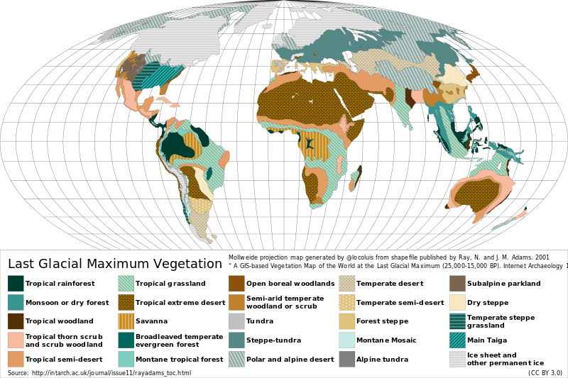
Español: Mapa de la vegetación durante el Último Máximo Glacial hace ~18.000 años atrás. English: Reconstructed vegetation cover at the Last Glacial Maximum period ~18,000 years ago, describing the type of vegetation cover present, based on fossil pollen samples recovered from lake and bog sediments. |
| 日期 | |
| 来源 |
Map generated from shapefile published by Ray, N. and J. M. Adams. 2001, “ A GIS-based Vegetation Map of the World at the Last Glacial Maximum (25,000-15,000 BP). Internet Archaeology 11. ” Source: http://intarch.ac.uk/journal/issue11/rayadams_toc.html |
| 作者 | Locoluis |
| English | Spanish |
|---|---|
| Tropical rainforest | Selva tropical |
| Monsoon or dry forest | Monzón o bosque seco |
| Tropical woodland | Sabana arbolada tropical |
| Tropical thorn scrub and scrub woodland | Matorral espinoso tropical y bosque de matorral |
| Tropical semi-desert | Semi-desierto tropical |
| Tropical grassland | Pradera tropical |
| Tropical extreme desert | Desierto extremo tropical |
| Savanna | Sabana |
| Broadleaved temperate evergreen forest | Bosque siempreverde templado de hojas anchas |
| Montane tropical forest | Bosque tropical montano |
| Open boreal woodlands | Bosque boreal abierto |
| Semi-arid temperate woodland or scrub | Sabana arbolada o matorral templado semi-árido |
| Tundra | Tundra |
| Steppe-tundra | Estepa-tundra |
| Polar and alpine desert | Desierto polar y alpino |
| Temperate desert | Desierto templado |
| Temperate semi-desert | Semi-desierto templado |
| Forest steppe | Bosque estepa |
| Montane mosaic | Mosaico montano |
| Alpine tundra | Tundra alpina |
| Subalpine parkland | Zona verde subalpina |
| Dry steppe | Estepa seca |
| Temperate steppe grassland | Pastizal de estepa templada |
| Main Taiga | Taiga principal |
| Ice sheet and other permanent ice | Campos de hielo y otro hielos permanentes |
许可协议
[编辑]
本文件采用知识共享署名 3.0 未本地化版本许可协议授权。
- 您可以自由地:
- 共享 – 复制、发行并传播本作品
- 修改 – 改编作品
- 惟须遵守下列条件:
- 署名 – 您必须对作品进行署名,提供授权条款的链接,并说明是否对原始内容进行了更改。您可以用任何合理的方式来署名,但不得以任何方式表明许可人认可您或您的使用。
文件历史
点击某个日期/时间查看对应时刻的文件。
| 日期/时间 | 缩略图 | 大小 | 用户 | 备注 | |
|---|---|---|---|---|---|
| 当前 | 2015年8月23日 (日) 02:12 | | 1,200 × 800(316 KB) | Locoluis(留言 | 贡献) | Minor font adjustments. Typo in original source. |
| 2015年8月23日 (日) 02:01 |  | 1,200 × 800(316 KB) | Locoluis(留言 | 贡献) | User created page with UploadWizard |
您不可以覆盖此文件。
文件用途
以下2个页面使用本文件:
全域文件用途
以下其他wiki使用此文件:
- als.wikipedia.org上的用途
- ar.wikipedia.org上的用途
- bcl.wikipedia.org上的用途
- be.wikipedia.org上的用途
- ca.wikipedia.org上的用途
- cs.wikipedia.org上的用途
- da.wikipedia.org上的用途
- de.wikipedia.org上的用途
- el.wikipedia.org上的用途
- en.wikipedia.org上的用途
- es.wikipedia.org上的用途
- fr.wikipedia.org上的用途
- fy.wikipedia.org上的用途
- ga.wikipedia.org上的用途
- hy.wikipedia.org上的用途
- it.wikipedia.org上的用途
- ja.wikipedia.org上的用途
- la.wikipedia.org上的用途
- mk.wikipedia.org上的用途
- nn.wikipedia.org上的用途
查看此文件的更多全域用途。