File:Legal status of German in Europe.svg
ナビゲーションに移動
検索に移動

この SVG ファイルのこの PNG プレビューのサイズ: 769 × 552 ピクセル. その他の解像度: 320 × 230 ピクセル | 640 × 459 ピクセル | 1,024 × 735 ピクセル | 1,280 × 919 ピクセル | 2,560 × 1,838 ピクセル。
元のファイル (SVG ファイル、769 × 552 ピクセル、ファイルサイズ: 8.19メガバイト)
キャプション
キャプション
このファイルの内容を1行で記述してください
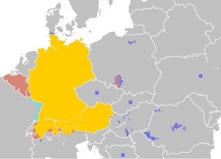
German language in Europe
概要[編集]
| 解説 |
|
| 日付 | |
| 原典 |
|
| 作者 | 37ophiuchi |
| その他のバージョン |
|

.png)
ライセンス[編集]
この作品の著作権者である私は、この作品を以下のライセンスで提供します。
このファイルはクリエイティブ・コモンズ 表示-継承 4.0 国際ライセンスのもとに利用を許諾されています。
- あなたは以下の条件に従う場合に限り、自由に
- 共有 – 本作品を複製、頒布、展示、実演できます。
- 再構成 – 二次的著作物を作成できます。
- あなたの従うべき条件は以下の通りです。
- 表示 – あなたは適切なクレジットを表示し、ライセンスへのリンクを提供し、変更があったらその旨を示さなければなりません。これらは合理的であればどのような方法で行っても構いませんが、許諾者があなたやあなたの利用行為を支持していると示唆するような方法は除きます。
- 継承 – もしあなたがこの作品をリミックスしたり、改変したり、加工した場合には、あなたはあなたの貢献部分を元の作品とこれと同一または互換性があるライセンスの下に頒布しなければなりません。
ファイルの履歴
過去の版のファイルを表示するには、その版の日時をクリックしてください。
| 日付と時刻 | サムネイル | 寸法 | 利用者 | コメント | |
|---|---|---|---|---|---|
| 現在の版 | 2015年9月8日 (火) 16:58 | | 769 × 552 (8.19メガバイト) | 37ophiuchi (トーク | 投稿記録) | removed tiny white frame |
| 2015年9月8日 (火) 14:10 |  | 770 × 552 (8.19メガバイト) | 37ophiuchi (トーク | 投稿記録) | added language islands in northern italy (those that still exist and have official minority rights). added minority square to bosnia-herzegovina. resized. | |
| 2015年7月7日 (火) 17:51 |  | 435 × 312 (8.18メガバイト) | 37ophiuchi (トーク | 投稿記録) | changed color of striped area | |
| 2015年7月2日 (木) 22:07 |  | 435 × 312 (8.18メガバイト) | 37ophiuchi (トーク | 投稿記録) | refined poland and hungary | |
| 2015年7月2日 (木) 10:48 |  | 435 × 312 (7.85メガバイト) | 37ophiuchi (トーク | 投稿記録) | User created page with UploadWizard |
このファイルは上書きできません。
ファイルの使用状況
以下の 6 ページがこのファイルを使用しています:
グローバルなファイル使用状況
以下に挙げる他のウィキがこの画像を使っています:
- ab.wikipedia.org での使用状況
- ady.wikipedia.org での使用状況
- af.wikipedia.org での使用状況
- af.wikibooks.org での使用状況
- am.wikipedia.org での使用状況
- ang.wikipedia.org での使用状況
- anp.wikipedia.org での使用状況
- an.wikipedia.org での使用状況
- arc.wikipedia.org での使用状況
- ar.wikipedia.org での使用状況
- ar.wikibooks.org での使用状況
- ar.wikinews.org での使用状況
- ary.wikipedia.org での使用状況
- arz.wikipedia.org での使用状況
- ast.wikipedia.org での使用状況
- as.wikipedia.org での使用状況
- ay.wikipedia.org での使用状況
- az.wikipedia.org での使用状況
- az.wikibooks.org での使用状況
- ban.wikipedia.org での使用状況
- bat-smg.wikipedia.org での使用状況
- ba.wikipedia.org での使用状況
- bcl.wikipedia.org での使用状況
- be-tarask.wikipedia.org での使用状況
- be.wikipedia.org での使用状況
- bh.wikipedia.org での使用状況
- bn.wikipedia.org での使用状況
- bo.wikipedia.org での使用状況
- br.wikipedia.org での使用状況
- bxr.wikipedia.org での使用状況
- ca.wikipedia.org での使用状況
- cdo.wikipedia.org での使用状況
- ceb.wikipedia.org での使用状況
- ce.wikipedia.org での使用状況
- chr.wikipedia.org での使用状況
- chy.wikipedia.org での使用状況
- crh.wikipedia.org での使用状況
- csb.wikipedia.org での使用状況
- cs.wikipedia.org での使用状況
- cs.wikibooks.org での使用状況
このファイルのグローバル使用状況を表示する。