File:Libya-War-Map.png
Zur Navigation springen
Zur Suche springen
Größe dieser Vorschau: 800 × 411 Pixel. Weitere Auflösungen: 320 × 164 Pixel | 640 × 329 Pixel | 1.024 × 526 Pixel | 1.280 × 657 Pixel | 2.000 × 1.027 Pixel.
Originaldatei (2.000 × 1.027 Pixel, Dateigröße: 243 KB, MIME-Typ: image/png)
Bildtexte
Kurzbeschreibungen
Ergänze eine einzeilige Erklärung, was diese Datei darstellt.

|
Dieses Bild des Typs Military map sollte als Vektorgrafik im SVG-Format neu erstellt werden. Vektorformate haben zahlreiche Vorteile; weitere Information unter Commons:Media for cleanup. Wenn dir eine SVG-Version dieses Bildes vorliegt, so lade diese bitte hoch. Nach dem Hochladen der Datei ist diese Vorlage auf der aktuellen Bildbeschreibungsseite durch die Vorlage {{Vector version available}}, oder kürzer {{Vva}}, zu ersetzen. Es ist empfohlen die neue SVG-Datei „Libya-War-Map.svg“ zu nennen – dann benötigt die Vorlage vector version available (bzw. vva) keinen Parameter.
|
Beschreibung
[Bearbeiten]
| Beschreibung |
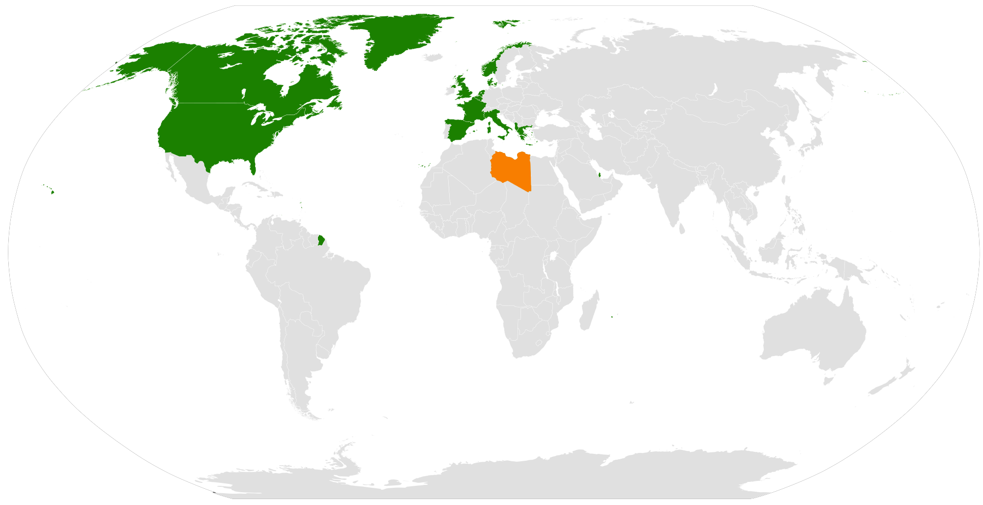
English: A map of the belligerents of the Libyan war. |
||
| Quelle | Eigenes Werk | ||
| Urheber | Cowik | ||
| Genehmigung (Weiternutzung dieser Datei) |
|
Lizenz
[Bearbeiten]
Ich, der Urheber dieses Werkes, veröffentliche es unter der folgenden Lizenz:
| Ich, der Urheberrechtsinhaber dieses Werkes, veröffentliche es als gemeinfrei. Dies gilt weltweit. In manchen Staaten könnte dies rechtlich nicht möglich sein. Sofern dies der Fall ist: Ich gewähre jedem das bedingungslose Recht, dieses Werk für jedweden Zweck zu nutzen, es sei denn, Bedingungen sind gesetzlich erforderlich. |
Ursprüngliches Datei-Logbuch
[Bearbeiten]
This image is a derivative work of the following images:
- File:BlankMap-World6.svg licensed with PD-self
- 2011-02-17T14:31:36Z NuclearVacuum 863x443 (1614903 Bytes) minor fixes
- 2011-02-13T01:43:20Z Canuckguy 863x443 (1632654 Bytes) minor fix
- 2011-01-22T20:16:24Z NuclearVacuum 863x443 (1614900 Bytes) added lakes
- 2011-01-22T20:12:02Z NuclearVacuum 863x443 (1632622 Bytes) ...
- 2011-01-22T20:08:04Z NuclearVacuum 863x443 (1632651 Bytes) Reverted to version as of 18:31, 17 January 2011
- 2011-01-22T20:07:39Z NuclearVacuum 1173x937 (334238 Bytes) just testing something
- 2011-01-17T18:31:33Z NuclearVacuum 863x443 (1632651 Bytes) minor fix of Sudan
- 2011-01-17T18:26:18Z NuclearVacuum 863x443 (1632651 Bytes) minor fix
- 2011-01-17T18:17:24Z NuclearVacuum 863x443 (1632633 Bytes) clean code
- 2011-01-17T18:12:07Z NuclearVacuum 863x443 (1632625 Bytes) added new class of circles, added Southern Sudan as a region within Sudan.
- 2011-01-15T00:06:15Z NuclearVacuum 863x443 (1631574 Bytes) minor fix
- 2011-01-14T23:51:44Z NuclearVacuum 863x443 (1631571 Bytes) added missing regions of the European Union
- 2011-01-13T14:26:50Z NuclearVacuum 863x443 (1631559 Bytes) minor fix
- 2011-01-13T14:17:57Z NuclearVacuum 863x443 (1631550 Bytes) added the BES Islands to the Netherladns
- 2011-01-07T21:02:08Z NuclearVacuum 863x443 (1631333 Bytes) minor fix
- 2011-01-07T20:55:32Z NuclearVacuum 863x443 (1631333 Bytes) corrected code for the circles
- 2011-01-06T16:44:29Z NuclearVacuum 863x443 (1208206 Bytes) removed all but 5px of whitespace, see talk page
- 2011-01-03T14:03:40Z NuclearVacuum 854x433 (1208195 Bytes) Curaçao and Sint Maarten have been given codes
- 2011-01-02T03:21:03Z Tomchen1989 854x433 (1205379 Bytes) compromised for the bug
- 2010-12-28T01:58:24Z Kintetsubuffalo 853x433 (1205378 Bytes) what are you talking about? nothing is cut off or squished
- 2010-12-28T00:28:42Z NuclearVacuum 940x477 (1631321 Bytes) Reverted to version as of 16:43, 27 October 2010
- 2010-12-19T20:10:58Z Tomchen1989 853x433 (1205378 Bytes) stroke-width of coast
- 2010-12-19T08:51:57Z Tomchen1989 853x433 (1205378 Bytes) minor change
- 2010-12-16T16:14:47Z Tomchen1989 853x433 (1205378 Bytes) radius of the circles changed
- 2010-12-14T22:57:20Z Tomchen1989 853x433 (1208461 Bytes) small fixed
- 2010-12-14T22:36:00Z Tomchen1989 853x433 (1208830 Bytes) had outside whitespace removed; cleaned the code; used tab indent
- 2010-10-27T16:43:23Z NuclearVacuum 940x477 (1631321 Bytes) fixed as part of discussion
- 2010-10-24T03:54:05Z NuclearVacuum 940x477 (1630960 Bytes) I fixed the code so it is valid
- 2010-10-10T22:06:16Z Canuckguy 940x477 (1630991 Bytes) Reverted to version as of 02:01, 18 September 2010 (Neth. Antilles removed, Sint Maarten and Curacao added, Bonaire part of "nl")
- 2010-09-18T02:01:50Z Canuckguy 940x477 (1630802 Bytes) Reverted to version as of 01:03, 9 July 2010. New version to be used October 10, 2010
- 2010-09-18T02:01:03Z Canuckguy 940x477 (1630991 Bytes) version with Sint Maarten and Curacao added, Bonaire as part of Netherlands, and Netherlands Antilles removed. To be used starting October 10, 2010
- 2010-07-09T01:03:28Z NuclearVacuum 940x477 (1630802 Bytes) after thinking about it, I think "aa" is better for the ocean than "zz"
- 2010-07-07T21:49:57Z NuclearVacuum 940x477 (1630805 Bytes) Reverted to version as of 20:25, 7 July 2010
- 2010-07-07T21:49:26Z NuclearVacuum 940x477 (1629207 Bytes) Reverted to version as of 16:45, 25 June 2010
- 2010-07-07T21:48:28Z NuclearVacuum 940x477 (1630623 Bytes) Reverted to version as of 16:51, 29 June 2010 checking
- 2010-07-07T21:47:19Z NuclearVacuum 940x477 (1630506 Bytes) Reverted to version as of 14:49, 1 July 2010 checking something
- 2010-07-07T20:25:43Z NuclearVacuum 940x477 (1630805 Bytes) added marker for Swaziland
- 2010-07-07T19:43:09Z NuclearVacuum 940x477 (1630656 Bytes) added the European Union
- 2010-07-01T14:49:16Z NuclearVacuum 940x477 (1630506 Bytes) minor mistake
- 2010-07-01T14:47:13Z NuclearVacuum 940x477 (1630506 Bytes) Created code for the French Southern and Antarctic Lands.
- 2010-06-29T16:51:08Z NuclearVacuum 940x477 (1630623 Bytes) minor code cleanup
- 2010-06-28T22:28:48Z NuclearVacuum 940x477 (1630576 Bytes) new version taking into account the unrecognized nations and using user-assigned code.
- 2010-06-28T20:16:10Z NuclearVacuum 940x477 (1630640 Bytes) added separate class for unrecognized nations, minor cleanup
- 2010-06-28T20:00:16Z NuclearVacuum 940x477 (1630500 Bytes) checking again
- 2010-06-28T19:47:25Z NuclearVacuum 940x477 (1630500 Bytes) checking something
- 2010-06-28T18:57:05Z NuclearVacuum 940x477 (1630523 Bytes) Minor corrections involving lakes. Made a gap within South Africa where Lesotho should go.
- 2010-06-27T04:45:54Z NuclearVacuum 940x477 (1631933 Bytes) removed different coloring for Antarctica, as there is no real reason it should be in a different color, plus with the coloring changes recently made, the color used for Antarctica has no real difference.
- 2010-06-25T16:45:04Z Lokal Profil 940x477 (1629207 Bytes) Reverting to version from 17:47, April 18, 2010 but with Yug's colour change redone so as not to double the filesize (encoding seems to have changed)
- 2010-06-24T01:09:58Z NuclearVacuum 940x477 (3261014 Bytes) minor correction
- 2010-06-23T16:55:45Z NuclearVacuum 940x477 (3261008 Bytes) minor
Dateiversionen
Klicke auf einen Zeitpunkt, um diese Version zu laden.
| Version vom | Vorschaubild | Maße | Benutzer | Kommentar | |
|---|---|---|---|---|---|
| aktuell | 02:14, 22. Mär. 2011 | | 2.000 × 1.027 (243 KB) | Cowik (Diskussion | Beiträge) | {{Information |Description ={{en|1=A map of the belligerents of the Libyan war.}} |Source ={{own}} |Author =Cowik |Date = |Permission ={{RetouchedPicture||editor=|orig=BlankMap-World6.svg}} |other_versions = |
Du kannst diese Datei nicht überschreiben.
Dateiverwendung
Die folgende Seite verwendet diese Datei:
Globale Dateiverwendung
Die nachfolgenden anderen Wikis verwenden diese Datei:
- Verwendung auf ca.wikipedia.org
- Verwendung auf ckb.wikipedia.org
- Verwendung auf cs.wikipedia.org
- Verwendung auf de.wikipedia.org
- Verwendung auf en.wikipedia.org
- Verwendung auf eu.wikipedia.org
- Verwendung auf fa.wikipedia.org
- Verwendung auf he.wikipedia.org
- Verwendung auf it.wikipedia.org
- Verwendung auf ko.wikipedia.org
- Verwendung auf ms.wikipedia.org
- Verwendung auf mzn.wikipedia.org
- Verwendung auf ru.wikipedia.org
- Verwendung auf www.wikidata.org
- Verwendung auf zh.wikipedia.org